TopoQuest Logo
Do you find TopoQuest useful?
Help keep TopoQuest running and adding new maps/features by donating!
Bitcoin:  19c7KJd3qBynnjoSw5npx9KScwjBe4ifkT
Litecoin:  LXs6TkuXGGXo1vDsWCkWVdjQX94eUKd6ui
Home View Maps Find Maps Find Places Resources & Links


Owens, Missouri Topographic Map

USGS Map Title: Owens, MO
USGS Map MRC: 37092B4
DRG (GeoTIFF) Download: o37092b4.tif


Neighboring USGS Topographic Map Quads:


  Hartville, MO  
37092C5
 

  Fuson, MO  
37092C4
 

  Dawson, MO  
37092C3
 

  Mansfield NE, MO  
37092B5
 

  Owens, MO  
37092B4
 

  Mountain Grove North, MO  
37092B3
 

  Mansfield, MO  
37092A5
 

  Norwood, MO  
37092A4
 

  Mountain Grove South, MO  
37092A3


Map MRC Location:

N38°
W93°
N38°
W92°
H8 H7 H6 H5 H4 H3 H2 H1
G8 G7 G6 G5 G4 G3 G2 G1
F8 F7 F6 F5 F4 F3 F2 F1
E8 E7 E6 E5 E4 E3 E2 E1
D8 D7 D6 D5 D4 D3 D2 D1
C8 C7 C6 C5 C4 C3 C2 C1
B8 B7 B6 B5 B4 B3 B2 B1
A8 A7 A6 A5 A4 A3 A2 A1
N37°
W93°
N37°
W92°

Owens, MO USGS 1:24K Topographic Map Preview:
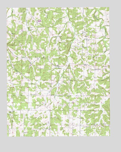
Owens, MO USGS Topographic Map
Click on map above to begin viewing in our Map Viewer.

This topographic map contains these locations and features:
Feature Name Type Latitude Longitude GNIS ID View Map
Blanchard SchoolSchoolN37.1928°W92.3788°714350View Map
Bruton SinksBasinN37.1323°W92.4341°714927View Map
Carter BranchStreamN37.2370°W92.4232°715439View Map
Carter CemeteryCemeteryN37.2353°W92.4252°715440View Map
Carter SchoolSchoolN37.2220°W92.4368°715447View Map
Caudle ChurchChurchN37.1428°W92.4107°715507View Map
Caudle School (historical)SchoolN37.1359°W92.4099°735062View Map
Cox CemeteryCemeteryN37.2453°W92.4502°716423View Map
Crossroads StorePopulated PlaceN37.1895°W92.3927°740784View Map
Curtis ChurchChurchN37.1653°W92.4463°716607View Map
DugganPopulated PlaceN37.1942°W92.4138°740513View Map
Duggan Post OfficePost OfficeN37.1942°W92.4138°760010View Map
Duggan School (historical)SchoolN37.1948°W92.4099°735060View Map
Frog Knob CemeteryCemeteryN37.2159°W92.4315°718259View Map
Happy Ridge ChurchChurchN37.1764°W92.4691°719078View Map
Jackson CemeteryCemeteryN37.1325°W92.4507°720205View Map
Kelly SchoolSchoolN37.1645°W92.4274°720521View Map
Kennel CemeteryCemeteryN37.2106°W92.4579°720539View Map
Liberty SchoolSchoolN37.1289°W92.4802°720986View Map
Moore CemeteryCemeteryN37.2289°W92.4715°722571View Map
Moore SchoolSchoolN37.2012°W92.4538°722582View Map
Mount Zion CemeteryCemeteryN37.1773°W92.4293°722928View Map
Mount Zion ChurchChurchN37.1789°W92.4229°722948View Map
Oak Grove ChurchChurchN37.2112°W92.4029°723579View Map
OwensPopulated PlaceN37.2189°W92.4029°723903View Map
Owens SchoolSchoolN37.2231°W92.3966°723912View Map
Peace Valley ChurchChurchN37.1656°W92.4657°724139View Map
Pinchem Church (historical)ChurchN37.1312°W92.4479°735064View Map
Raney BranchStreamN37.2114°W92.3788°725101View Map
Raney CemeteryCemeteryN37.2084°W92.3777°725102View Map
Rattlesnake Den SpringSpringN37.1483°W92.4962°725115View Map
Red Hill ChurchChurchN37.2248°W92.4902°725157View Map
Rock ChapelChurchN37.2217°W92.4013°725434View Map
Shaw BranchStreamN37.1967°W92.4702°726286View Map
Shaw CemeteryCemeteryN37.2003°W92.4624°726288View Map
Sparks SpringSpringN37.1932°W92.4372°726830View Map
Spillman CemeteryCemeteryN37.2100°W92.4196°726860View Map
Stony Point School (historical)SchoolN37.1326°W92.4488°735063View Map
Tharpe School (historical)SchoolN37.1653°W92.4657°735059View Map
Thomas CemeteryCemeteryN37.1303°W92.4129°727577View Map
Township of HartCivilN37.2046°W92.4629°767550View Map
Turner CemeteryCemeteryN37.2400°W92.4296°727896View Map
Ussery CemeteryCemeteryN37.2159°W92.4129°728088View Map
Walker School (historical)SchoolN37.1642°W92.4013°735061View Map

Note: Coordinates in the location and feature list above are referenced to NAD83 datum.


Copyright (C) 2008-2025 Ryan Niemi / Sunset Dynamics ... All Rights Reserved