TopoQuest Logo
Do you find TopoQuest useful?
Help keep TopoQuest running and adding new maps/features by donating!
Bitcoin:  19c7KJd3qBynnjoSw5npx9KScwjBe4ifkT
Litecoin:  LXs6TkuXGGXo1vDsWCkWVdjQX94eUKd6ui
Home View Maps Find Maps Find Places Resources & Links


Mansfield NE, Missouri Topographic Map

USGS Map Title: Mansfield NE, MO
USGS Map MRC: 37092B5
DRG (GeoTIFF) Download: o37092b5.tif


Neighboring USGS Topographic Map Quads:


  Duncan, MO  
37092C6
 

  Hartville, MO  
37092C5
 

  Fuson, MO  
37092C4
 

  Mansfield NW, MO  
37092B6
 

  Mansfield NE, MO  
37092B5
 

  Owens, MO  
37092B4
 

  Cedar Gap, MO  
37092A6
 

  Mansfield, MO  
37092A5
 

  Norwood, MO  
37092A4


Map MRC Location:

N38°
W93°
N38°
W92°
H8 H7 H6 H5 H4 H3 H2 H1
G8 G7 G6 G5 G4 G3 G2 G1
F8 F7 F6 F5 F4 F3 F2 F1
E8 E7 E6 E5 E4 E3 E2 E1
D8 D7 D6 D5 D4 D3 D2 D1
C8 C7 C6 C5 C4 C3 C2 C1
B8 B7 B6 B5 B4 B3 B2 B1
A8 A7 A6 A5 A4 A3 A2 A1
N37°
W93°
N37°
W92°

Mansfield NE, MO USGS 1:24K Topographic Map Preview:
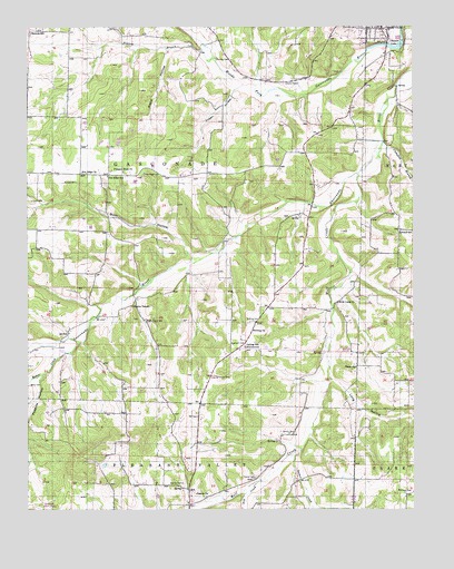
Mansfield NE, MO USGS Topographic Map
Click on map above to begin viewing in our Map Viewer.

This topographic map contains these locations and features:
Feature Name Type Latitude Longitude GNIS ID View Map
Alsop HollowValleyN37.2442°W92.5796°713247View Map
Baker CreekStreamN37.1678°W92.6088°713570View Map
Berry CemeteryCemeteryN37.1570°W92.6241°713992View Map
Binkley CemeteryCemeteryN37.2417°W92.5635°714252View Map
Boatright CemeteryCemeteryN37.1678°W92.5588°714462View Map
Buck HollowValleyN37.1909°W92.5729°714970View Map
Campbell BranchStreamN37.2201°W92.5096°715299View Map
Casador LakeReservoirN37.2450°W92.5078°758260View Map
Casador Lake DamDamN37.2464°W92.5034°763680View Map
Claxton CemeteryCemeteryN37.2353°W92.5371°715903View Map
Dennis CemeteryCemeteryN37.1445°W92.5407°716836View Map
Dennis ChurchChurchN37.1289°W92.5707°716837View Map
Dugger HollowValleyN37.2339°W92.5577°717162View Map
Elmwood CemeteryCemeteryN37.1595°W92.5640°717551View Map
Fagan SchoolSchoolN37.1617°W92.5188°717721View Map
Fry CreekStreamN37.1323°W92.5504°718273View Map
Hartville Fire and RescueBuildingN37.2491°W92.5066°2620262View Map
Helsley CemeteryCemeteryN37.1317°W92.5752°719357View Map
High Point SchoolSchoolN37.1739°W92.5874°719543View Map
Johnson SchoolSchoolN37.1970°W92.5043°720380View Map
Long HollowValleyN37.1589°W92.5271°721545View Map
Mansfield Municipal AirportAirportN37.1258°W92.6225°758800View Map
Matlock CemeteryCemeteryN37.2098°W92.6091°721972View Map
McIntosh CemeteryCemeteryN37.1292°W92.5029°722131View Map
Mission TempleChurchN37.1776°W92.5913°722470View Map
Newton SchoolSchoolN37.2484°W92.6238°723343View Map
Oetting CemeteryCemeteryN37.1739°W92.5521°723702View Map
Oetting ChurchChurchN37.1714°W92.5521°735764View Map
Oetting SchoolLocaleN37.1673°W92.5546°723703View Map
Pea Ridge CemeteryCemeteryN37.2120°W92.5871°724124View Map
Pea Ridge ChurchChurchN37.2126°W92.6074°724126View Map
Pea Ridge SchoolSchoolN37.2114°W92.5993°724132View Map
Pleasant Hope ChurchChurchN37.2126°W92.5941°724563View Map
Possum HollowValleyN37.1595°W92.6204°724777View Map
Prairie BranchStreamN37.2420°W92.5646°724820View Map
Quillen BranchStreamN37.2128°W92.5021°725025View Map
Rembert (historical)Populated PlaceN37.2431°W92.5477°740460View Map
Rembert Post OfficePost OfficeN37.2431°W92.5477°760019View Map
Spence CreekStreamN37.1406°W92.5368°726845View Map
Township of GasconadeCivilN37.2073°W92.5988°767549View Map
Turner CemeteryCemeteryN37.1331°W92.5515°727895View Map
UmpirePopulated PlaceN37.1798°W92.6060°740459View Map
Umpire Post OfficePost OfficeN37.1798°W92.6060°760022View Map
Wolf CreekStreamN37.2114°W92.5177°729046View Map
Wolf Creek ChurchChurchN37.1787°W92.5246°729054View Map

Note: Coordinates in the location and feature list above are referenced to NAD83 datum.


Copyright (C) 2008-2025 Ryan Niemi / Sunset Dynamics ... All Rights Reserved