TopoQuest Logo
Do you find TopoQuest useful?
Help keep TopoQuest running and adding new maps/features by donating!
Bitcoin:  19c7KJd3qBynnjoSw5npx9KScwjBe4ifkT
Litecoin:  LXs6TkuXGGXo1vDsWCkWVdjQX94eUKd6ui
Home View Maps Find Maps Find Places Resources & Links


Harvard, Texas Topographic Map

USGS Map Title: Harvard, TX
USGS Map MRC: 33094A8
DRG (GeoTIFF) Download: o33094a8.tif


Neighboring USGS Topographic Map Quads:


  Winfield, TX  
33095B1
 

  Mount Pleasant, TX  
33094B8
 

  Cookville, TX  
33094B7
 

  Monticello, TX  
33095A1
 

  Harvard, TX  
33094A8
 

  Cason, TX  
33094A7
 

  Leesburg, TX  
32095H1
 

  Pittsburg, TX  
32094H8
 

  Lafayette, TX  
32094H7


Map MRC Location:

N34°
W95°
N34°
W94°
H8 H7 H6 H5 H4 H3 H2 H1
G8 G7 G6 G5 G4 G3 G2 G1
F8 F7 F6 F5 F4 F3 F2 F1
E8 E7 E6 E5 E4 E3 E2 E1
D8 D7 D6 D5 D4 D3 D2 D1
C8 C7 C6 C5 C4 C3 C2 C1
B8 B7 B6 B5 B4 B3 B2 B1
A8 A7 A6 A5 A4 A3 A2 A1
N33°
W95°
N33°
W94°

Harvard, TX USGS 1:24K Topographic Map Preview:
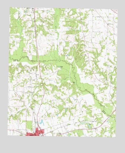
Harvard, TX USGS Topographic Map
Click on map above to begin viewing in our Map Viewer.

This topographic map contains these locations and features:
Feature Name Type Latitude Longitude GNIS ID View Map
Beaver Club DamDamN33.0101°W94.9035°1862112View Map
Beaver LakeReservoirN33.0109°W94.9057°1330271View Map
Chapel Hill SchoolSchoolN33.1107°W94.8863°1332660View Map
Church of GodChurchN33.0015°W94.9747°2016686View Map
Concord CemeteryCemeteryN33.1115°W94.9622°1333213View Map
Cypress ChurchChurchN33.0740°W94.9080°1333848View Map
D M Cook CemeteryCemeteryN33.0760°W94.9216°1333264View Map
Deishler John Freedom Fellowship ChurchChurchN33.0007°W94.9591°2016689View Map
East New Hope ChurchChurchN33.1173°W94.8952°1334972View Map
East Texas Medical CenterHospitalN33.0332°W94.9589°2015642View Map
FakerLocaleN33.0146°W94.9030°1335660View Map
Handsome CemeteryCemeteryN33.0198°W94.9038°1337302View Map
Hart CreekStreamN33.0748°W94.9408°1337419View Map
HarvardPopulated PlaceN33.0598°W94.9683°1378423View Map
Hopkins LakeLakeN33.0683°W94.9417°1338073View Map
J H Milligan Estate DamDamN33.0168°W94.9619°1862110View Map
J H Milligan Estate LakeReservoirN33.0142°W94.9603°1862111View Map
Lang ChapelChurchN33.0529°W94.8822°1339616View Map
MacedoniaPopulated PlaceN33.0476°W94.9735°1378631View Map
Mount Pleasant Regional AirportAirportN33.0978°W94.9646°2675920View Map
Nortex Volunteer Fire DepartmentBuildingN33.1226°W94.8799°2655456View Map
North ChapelChurchN33.0548°W94.9697°1342704View Map
North Chapel CemeteryCemeteryN33.0415°W94.9763°1342705View Map
Pecan HeightsPopulated PlaceN33.0021°W94.9422°1343775View Map
Pittsburg Middle SchoolSchoolN33.0040°W94.9777°2003656View Map
Pittsburg Primary SchoolSchoolN33.0060°W94.9791°2003657View Map
Polk Ranch Airport (historical)AirportN33.0437°W94.9266°1387325View Map
Prairie BranchStreamN33.0368°W94.8977°1344480View Map
Richardson FieldAirportN33.0173°W94.9707°2676574View Map
Sandlin LakeReservoirN33.0868°W94.9352°1864344View Map
Sandlin Lake DamDamN33.0868°W94.9352°1864343View Map
Spring HillPopulated PlaceN33.0085°W94.9002°1379101View Map
Tankersley CreekStreamN33.0773°W94.9844°1348230View Map
Tiddle LakeLakeN33.0523°W94.9230°1348549View Map
Traylor CemeteryCemeteryN33.0090°W94.9094°1348736View Map
Walkers CreekStreamN33.0523°W94.9216°1376619View Map
William Cook CemeteryCemeteryN33.1064°W94.9116°1333265View Map

Note: Coordinates in the location and feature list above are referenced to NAD83 datum.


Copyright (C) 2008-2024 Ryan Niemi / Sunset Dynamics ... All Rights Reserved