TopoQuest Logo
Do you find TopoQuest useful?
Help keep TopoQuest running and adding new maps/features by donating!
Bitcoin:  19c7KJd3qBynnjoSw5npx9KScwjBe4ifkT
Litecoin:  LXs6TkuXGGXo1vDsWCkWVdjQX94eUKd6ui
Home View Maps Find Maps Find Places Resources & Links


Leesburg, Texas Topographic Map

USGS Map Title: Leesburg, TX
USGS Map MRC: 32095H1
DRG (GeoTIFF) Download: o32095h1.tif


Neighboring USGS Topographic Map Quads:


  New Hope, TX  
33095A2
 

  Monticello, TX  
33095A1
 

  Harvard, TX  
33094A8
 

  Newsome, TX  
32095H2
 

  Leesburg, TX  
32095H1
 

  Pittsburg, TX  
32094H8
 

  Rhonesboro, TX  
32095G2
 

  Thomas, TX  
32095G1
 

  Bettie, TX  
32094G8


Map MRC Location:

N33°
W96°
N33°
W95°
H8 H7 H6 H5 H4 H3 H2 H1
G8 G7 G6 G5 G4 G3 G2 G1
F8 F7 F6 F5 F4 F3 F2 F1
E8 E7 E6 E5 E4 E3 E2 E1
D8 D7 D6 D5 D4 D3 D2 D1
C8 C7 C6 C5 C4 C3 C2 C1
B8 B7 B6 B5 B4 B3 B2 B1
A8 A7 A6 A5 A4 A3 A2 A1
N32°
W96°
N32°
W95°

Leesburg, TX USGS 1:24K Topographic Map Preview:
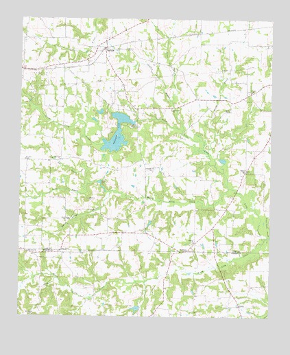
Leesburg, TX USGS Topographic Map
Click on map above to begin viewing in our Map Viewer.

This topographic map contains these locations and features:
Feature Name Type Latitude Longitude GNIS ID View Map
Arthur Reeves BranchStreamN32.9090°W95.0005°1329786View Map
Bailey BranchStreamN32.9307°W95.0913°1329925View Map
BrumleyPopulated PlaceN32.8796°W95.0149°1378058View Map
Centeridge ChurchChurchN32.9365°W95.0599°1332556View Map
Chaffin BranchStreamN32.9532°W95.0447°1332607View Map
Damascus ChurchChurchN32.8876°W95.1122°1334022View Map
Ellison BranchStreamN32.9440°W95.0322°1335334View Map
Fairview ChurchChurchN32.9065°W95.0380°1335643View Map
Faith Temple ChurchChurchN32.9410°W95.1052°1335659View Map
Ferndale DamDamN32.9568°W95.0669°1862122View Map
Ferndale LakeReservoirN32.9517°W95.0770°1335752View Map
Ferndale Lake ClubLocaleN32.9548°W95.0699°1335753View Map
Harris LakeReservoirN32.8785°W95.0666°1861621View Map
Harris Lake DamDamN32.8785°W95.0652°1861620View Map
Hickory HillPopulated PlaceN32.9365°W95.0124°1378445View Map
Hopewell CemeteryCemeteryN32.9107°W95.0738°1338058View Map
Lamar BranchStreamN32.9660°W95.0499°1374451View Map
LeesburgPopulated PlaceN32.9876°W95.0838°1339795View Map
Leesburg Post OfficePost OfficeN32.9896°W95.0846°2731467View Map
Leesburg-Newsome DivisionCivilN32.9645°W95.1074°1938915View Map
Living Green ChurchChurchN32.9612°W95.0494°1340267View Map
Lone Star BranchStreamN32.9307°W95.0913°1340391View Map
Macedonia ChurchChurchN32.9240°W95.0902°1340805View Map
MatinburgPopulated PlaceN32.9023°W95.0447°1378649View Map
Middle Lilly CreekStreamN32.9293°W95.0210°1341502View Map
Mount Lebanon ChurchChurchN32.8754°W95.1183°1342047View Map
Myrtle Springs BranchStreamN32.9248°W95.0683°1342347View Map
Myrtle Springs ChurchChurchN32.9157°W95.1005°1342350View Map
New Mine ChurchChurchN32.9698°W95.0099°1342496View Map
New West ChapelChurchN32.9407°W95.1224°1342529View Map
Newsome Oil FieldOilfieldN32.9751°W95.1161°1342573View Map
North Lilly CreekStreamN32.9293°W95.0210°1342772View Map
Oak Grove CemeteryCemeteryN32.9868°W95.0783°1342966View Map
Oak Grove ChurchChurchN32.9871°W95.0724°1342976View Map
Piney GrovePopulated PlaceN32.9018°W95.1055°1378871View Map
Piney Grove ChurchChurchN32.9015°W95.1211°1344096View Map
Pittsburg Oil FieldOilfieldN32.9623°W95.0741°1344153View Map
Reeves ChapelChurchN32.9618°W95.0213°1345010View Map
South Lilly CreekStreamN32.9085°W95.0019°1347486View Map
Spencer LakeLakeN32.9312°W95.0852°1347646View Map

Note: Coordinates in the location and feature list above are referenced to NAD83 datum.


Copyright (C) 2008-2024 Ryan Niemi / Sunset Dynamics ... All Rights Reserved