TopoQuest Logo
Do you find TopoQuest useful?
Help keep TopoQuest running and adding new maps/features by donating!
Bitcoin:  19c7KJd3qBynnjoSw5npx9KScwjBe4ifkT
Litecoin:  LXs6TkuXGGXo1vDsWCkWVdjQX94eUKd6ui
Home View Maps Find Maps Find Places Resources & Links


Hayden, Arizona Topographic Map

USGS Map Title: Hayden, AZ
USGS Map MRC: 33110A7
DRG (GeoTIFF) Download: o33110a7.tif


Neighboring USGS Topographic Map Quads:


  Hot Tamale Peak, AZ  
33110B8
 

  El Capitan Mountain, AZ  
33110B7
 

  Mescal Warm Spring, AZ  
33110B6
 

  Kearny, AZ  
33110A8
 

  Hayden, AZ  
33110A7
 

  Christmas, AZ  
33110A6
 

  Crozier Peak, AZ  
32110H8
 

  Winkelman, AZ  
32110H7
 

  Dudleyville, AZ  
32110H6


Map MRC Location:

N34°
W111°
N34°
W110°
H8 H7 H6 H5 H4 H3 H2 H1
G8 G7 G6 G5 G4 G3 G2 G1
F8 F7 F6 F5 F4 F3 F2 F1
E8 E7 E6 E5 E4 E3 E2 E1
D8 D7 D6 D5 D4 D3 D2 D1
C8 C7 C6 C5 C4 C3 C2 C1
B8 B7 B6 B5 B4 B3 B2 B1
A8 A7 A6 A5 A4 A3 A2 A1
N33°
W111°
N33°
W110°

Hayden, AZ USGS 1:24K Topographic Map Preview:
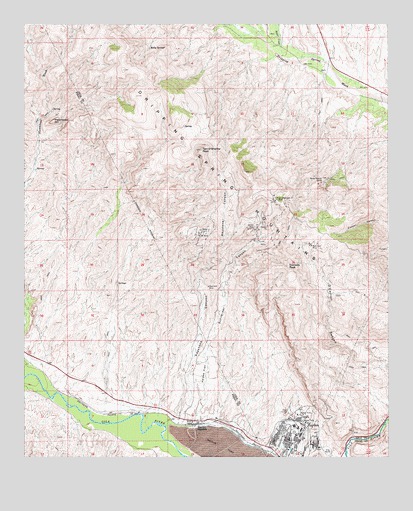
Hayden, AZ USGS Topographic Map
Click on map above to begin viewing in our Map Viewer.

This topographic map contains these locations and features:
Feature Name Type Latitude Longitude GNIS ID View Map
Burns Railroad StationBuildingN33.0128°W110.8343°23665View Map
Chilito (historical)LocaleN33.0667°W110.7971°42759View Map
Chilito MineMineN33.0667°W110.7968°2837View Map
Dripping Spring MountainsRangeN33.0831°W110.8132°4116View Map
Dripping Springs Census Designated PlaceCensusN33.1050°W110.7551°2582775View Map
Haines FlatFlatN33.0265°W110.8132°5505View Map
Hairpin SpringDamN33.0001°W110.7923°22338View Map
HaydenPopulated PlaceN33.0048°W110.7854°5646View Map
Hayden JunctionPopulated PlaceN33.0098°W110.8154°24455View Map
Hayden LibraryBuildingN33.0056°W110.7848°22339View Map
Hayden Police DepartmentBuildingN33.0049°W110.7856°2751572View Map
Hayden Post OfficePost OfficeN33.0062°W110.7839°44923View Map
Hayden Railroad StationBuildingN33.0112°W110.8254°23711View Map
Hayden Swimming Pool and ParkParkN33.0056°W110.7840°22340View Map
Hayden Volunteer Fire DepartmentBuildingN33.0046°W110.7845°2672517View Map
Kelly SpringsSpringN33.1184°W110.8332°6656View Map
Keystone CanyonValleyN33.0128°W110.8212°6677View Map
New Year MineMineN33.0612°W110.7771°8635View Map
Overland MineMineN33.0495°W110.8123°9038View Map
San Bernardo Junior MineMineN33.0748°W110.7887°10811View Map
Santa Monica CampLocaleN33.0809°W110.7759°10947View Map
Schneider CanyonValleyN33.0309°W110.8129°11007View Map
Seventynine MineMineN33.0645°W110.8140°14149View Map
Silver CreekStreamN33.1156°W110.7873°34433View Map
Smith WashStreamN33.0001°W110.8268°11471View Map
Steamboat MountainSummitN33.0976°W110.8657°11807View Map
Tam O'Shanter PeakSummitN33.0887°W110.8151°12135View Map
Tornado PeakSummitN33.0553°W110.7848°12639View Map
Velasco PitMineN33.0667°W110.7923°13206View Map

Note: Coordinates in the location and feature list above are referenced to NAD83 datum.


Copyright (C) 2008-2025 Ryan Niemi / Sunset Dynamics ... All Rights Reserved