TopoQuest Logo
Do you find TopoQuest useful?
Help keep TopoQuest running and adding new maps/features by donating!
Bitcoin:  19c7KJd3qBynnjoSw5npx9KScwjBe4ifkT
Litecoin:  LXs6TkuXGGXo1vDsWCkWVdjQX94eUKd6ui
Home View Maps Find Maps Find Places Resources & Links


Haynesville East, Louisiana Topographic Map

USGS Map Title: Haynesville East, LA
USGS Map MRC: 32093H1
DRG (GeoTIFF) Download: o32093h1.tif


Neighboring USGS Topographic Map Quads:


  Emerson, AR  
33093A2
 

  Emerson SE, AR  
33093A1
 

  Wesson SW, AR  
33092A8
 

  Haynesville West, LA  
32093H2
 

  Haynesville East, LA  
32093H1
 

  Colquitt, LA  
32092H8
 

  Blackburn, LA  
32093G2
 

  Homer, LA  
32093G1
 

  Arizona, LA  
32092G8


Map MRC Location:

N33°
W94°
N33°
W93°
H8 H7 H6 H5 H4 H3 H2 H1
G8 G7 G6 G5 G4 G3 G2 G1
F8 F7 F6 F5 F4 F3 F2 F1
E8 E7 E6 E5 E4 E3 E2 E1
D8 D7 D6 D5 D4 D3 D2 D1
C8 C7 C6 C5 C4 C3 C2 C1
B8 B7 B6 B5 B4 B3 B2 B1
A8 A7 A6 A5 A4 A3 A2 A1
N32°
W94°
N32°
W93°

Haynesville East, LA USGS 1:24K Topographic Map Preview:
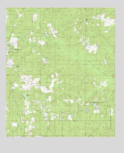
Haynesville East, LA USGS Topographic Map
Click on map above to begin viewing in our Map Viewer.

This topographic map contains these locations and features:
Feature Name Type Latitude Longitude GNIS ID View Map
Allen CemeteryCemeteryN32.8804°W93.0018°546966View Map
Antiock Lookout TowerTowerN32.8790°W93.0091°1630038View Map
Bethel ChurchChurchN32.9385°W93.0638°547063View Map
Brown CemeteryCemeteryN32.9874°W93.0336°544127View Map
Bucktail CampLocaleN32.9049°W93.0077°1630037View Map
Callender PondReservoirN32.9430°W93.1145°553860View Map
CampLocaleN32.8757°W93.1052°547167View Map
Campit LakeReservoirN32.9503°W93.0835°553867View Map
Cherokee SchoolSchoolN32.9279°W93.0391°547212View Map
Clampit Pond DamDamN32.9518°W93.0802°556840View Map
David Wade Correctional CenterBuildingN32.9045°W93.0196°540902View Map
David Wade Correctional Center Special Services District FacilitySchoolN32.9039°W93.0196°2462785View Map
Friendship CemeteryCemeteryN32.9447°W93.1244°547379View Map
Goodwin LakeReservoirN32.9151°W93.1030°554552View Map
Goodwin Lake DamDamN32.9118°W93.1018°556837View Map
GordonPopulated PlaceN32.9874°W93.0335°547407View Map
Gordon Heritage CemeteryCemeteryN32.9935°W93.0221°547893View Map
Hightower CemeteryCemeteryN32.9060°W93.0110°547463View Map
MahanPopulated PlaceN32.8913°W93.0454°555220View Map
Meadors CemeteryCemeteryN32.9274°W93.0346°547676View Map
Mount Hebron ChurchChurchN32.9976°W93.1227°547747View Map
Mount Obie ChurchChurchN32.8793°W93.0218°547751View Map
New Pine Hill CemeteryCemeteryN32.9001°W93.0913°547773View Map
Northwest Colquitt Oil and Gas FieldOilfieldN32.9751°W93.0196°544152View Map
OaksPopulated PlaceN32.9201°W93.1188°547789View Map
Old Pine Hill CemeteryCemeteryN32.8910°W93.1049°547799View Map
Owens CemeteryCemeteryN32.9780°W93.0377°547806View Map
Parish Governing Authority District 2CivilN32.9405°W93.0637°1929886View Map
Pine Hill SchoolSchoolN32.9013°W93.0835°547845View Map
Reeder CreekStreamN32.9679°W93.0668°547890View Map
Teague CemeteryCemeteryN32.9951°W93.0703°548068View Map
Ward TwoCivilN32.9829°W93.0318°544982View Map

Note: Coordinates in the location and feature list above are referenced to NAD83 datum.


Copyright (C) 2008-2025 Ryan Niemi / Sunset Dynamics ... All Rights Reserved