TopoQuest Logo
Do you find TopoQuest useful?
Help keep TopoQuest running and adding new maps/features by donating!
Bitcoin:  19c7KJd3qBynnjoSw5npx9KScwjBe4ifkT
Litecoin:  LXs6TkuXGGXo1vDsWCkWVdjQX94eUKd6ui
Home View Maps Find Maps Find Places Resources & Links


Wesson SW, Arkansas Topographic Map

USGS Map Title: Wesson SW, AR
USGS Map MRC: 33092A8
DRG (GeoTIFF) Download: o33092a8.tif


Neighboring USGS Topographic Map Quads:


  Spotville, AR  
33093B1
 

  Marysville, AR  
33092B8
 

  Newell, AR  
33092B7
 

  Emerson SE, AR  
33093A1
 

  Wesson SW, AR  
33092A8
 

  Wesson, AR  
33092A7
 

  Haynesville East, LA  
32093H1
 

  Colquitt, LA  
32092H8
 

  Summerfield, LA  
32092H7


Map MRC Location:

N34°
W93°
N34°
W92°
H8 H7 H6 H5 H4 H3 H2 H1
G8 G7 G6 G5 G4 G3 G2 G1
F8 F7 F6 F5 F4 F3 F2 F1
E8 E7 E6 E5 E4 E3 E2 E1
D8 D7 D6 D5 D4 D3 D2 D1
C8 C7 C6 C5 C4 C3 C2 C1
B8 B7 B6 B5 B4 B3 B2 B1
A8 A7 A6 A5 A4 A3 A2 A1
N33°
W93°
N33°
W92°

Wesson SW, AR USGS 1:24K Topographic Map Preview:
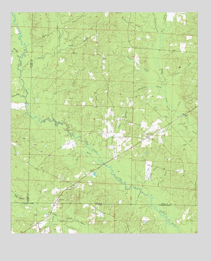
Wesson SW, AR USGS Topographic Map
Click on map above to begin viewing in our Map Viewer.

This topographic map contains these locations and features:
Feature Name Type Latitude Longitude GNIS ID View Map
Adams BranchStreamN33.0046°W92.8902°45780View Map
Black BranchStreamN33.0401°W92.9388°46655View Map
Black BranchStreamN33.1190°W92.9985°46658View Map
Blue BranchStreamN33.0657°W92.8885°46738View Map
Bond CreekStreamN33.0210°W92.9968°547118View Map
Caney CreekStreamN33.0857°W92.8993°47399View Map
Carnie (historical)Populated PlaceN33.1193°W92.9429°79116View Map
Clear CreekStreamN33.0643°W92.9716°47821View Map
Dodge CityPopulated PlaceN33.0196°W92.9685°57667View Map
Dry BranchStreamN33.0637°W92.9818°60274View Map
Garner CreekStreamN33.0924°W92.9935°49346View Map
Jolleys ChapelChurchN33.0565°W92.9088°77384View Map
Jolly Chapel CemeteryCemeteryN33.0557°W92.9090°60939View Map
Jordon BranchStreamN33.0504°W92.9482°50749View Map
Lambert DitchCanalN33.0715°W92.9404°50965View Map
Lemon CreekStreamN33.0832°W92.8965°45751View Map
Lewis LakeReservoirN33.0345°W92.9438°81203View Map
Lewis Lake DamDamN33.0335°W92.9435°81202View Map
Lick BranchStreamN33.1157°W92.9038°51133View Map
Lick CreekStreamN33.0090°W92.9690°547584View Map
Lick Creek Oil FieldOilfieldN33.0015°W92.9752°544141View Map
McCullough BranchStreamN33.0793°W92.8968°51813View Map
McLendon BranchStreamN33.0993°W92.9943°51866View Map
Moss BranchStreamN33.0674°W92.8838°52237View Map
New HopePopulated PlaceN33.0649°W92.9254°58256View Map
New Hope CemeteryCemeteryN33.0643°W92.9252°75252View Map
New Hope ChurchChurchN33.0651°W92.9265°60948View Map
Pigeon Roost CreekStreamN33.0774°W92.9907°53364View Map
Salem Baptist ChurchChurchN33.0999°W92.9379°78276View Map
Salem BranchStreamN33.1012°W92.9710°54485View Map
Salem CemeteryCemeteryN33.1021°W92.9590°54486View Map
Spring BranchStreamN33.0676°W92.9904°60266View Map
Three Creeks Volunteer Fire DepartmentBuildingN33.0561°W92.9064°2117208View Map
Township of TubalCivilN33.0657°W92.9402°69755View Map
Trinity ChapelChurchN33.0351°W92.9465°55653View Map
TubalPopulated PlaceN33.0626°W92.9196°79117View Map
Tubal Oil and Gas FieldOilfieldN33.0390°W92.9677°59872View Map
Union Ark ChurchChurchN33.0257°W92.9599°78612View Map
Union Arkansas CemeteryCemeteryN33.0257°W92.9588°59874View Map
West Three CreeksStreamN33.1107°W92.9002°56203View Map
Wright BranchStreamN33.0221°W92.8996°56552View Map

Note: Coordinates in the location and feature list above are referenced to NAD83 datum.


Copyright (C) 2008-2025 Ryan Niemi / Sunset Dynamics ... All Rights Reserved