TopoQuest Logo
Do you find TopoQuest useful?
Help keep TopoQuest running and adding new maps/features by donating!
Bitcoin:  19c7KJd3qBynnjoSw5npx9KScwjBe4ifkT
Litecoin:  LXs6TkuXGGXo1vDsWCkWVdjQX94eUKd6ui
Home View Maps Find Maps Find Places Resources & Links


Targhee Peak, Idaho Topographic Map

USGS Map Title: Targhee Peak, ID
USGS Map MRC: 44111F4
DRG (GeoTIFF) Download: o44111f4.tif


Neighboring USGS Topographic Map Quads:


  Cliff Lake, MT  
44111G5
 

  Earthquake Lake, MT  
44111G4
 

  Hebgen Dam, MT  
44111G3
 

  Hidden Lake Bench, MT  
44111F5
 

  Targhee Peak, ID  
44111F4
 

  Targhee Pass, ID  
44111F3
 

  Mount Jefferson, MT  
44111E5
 

  Sawtell Peak, ID  
44111E4
 

  Big Springs, ID  
44111E3


Map MRC Location:

N45°
W112°
N45°
W111°
H8 H7 H6 H5 H4 H3 H2 H1
G8 G7 G6 G5 G4 G3 G2 G1
F8 F7 F6 F5 F4 F3 F2 F1
E8 E7 E6 E5 E4 E3 E2 E1
D8 D7 D6 D5 D4 D3 D2 D1
C8 C7 C6 C5 C4 C3 C2 C1
B8 B7 B6 B5 B4 B3 B2 B1
A8 A7 A6 A5 A4 A3 A2 A1
N44°
W112°
N44°
W111°

Targhee Peak, ID USGS 1:24K Topographic Map Preview:
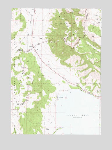
Targhee Peak, ID USGS Topographic Map
Click on map above to begin viewing in our Map Viewer.

This topographic map contains these locations and features:
Feature Name Type Latitude Longitude GNIS ID View Map
12S02E34DAD_01 WellWellN44.7260°W111.4583°807200View Map
Anthill SpringSpringN44.6546°W111.4922°779080View Map
Black MountainSummitN44.7108°W111.4150°397448View Map
Clark LakeLakeN44.7348°W111.3756°379370View Map
Duck CreekStreamN44.6308°W111.4280°380906View Map
Edwards LakeLakeN44.7395°W111.3828°381265View Map
Gillan CreekStreamN44.6385°W111.4350°382272View Map
Henrys LakeReservoirN44.6415°W111.4036°397786View Map
Henrys Lake Fish HatcheryLocaleN44.6649°W111.3869°401393View Map
Johnson RanchLocaleN44.6299°W111.4505°383999View Map
Kelly CreekStreamN44.6380°W111.4413°384132View Map
LakePopulated PlaceN44.6669°W111.3936°397840View Map
Raynolds PassGapN44.7110°W111.4697°789424View Map
Staley SpringsPopulated PlaceN44.6602°W111.4352°398177View Map
Targhee CreekStreamN44.6413°W111.3786°391848View Map
Targhee PeakSummitN44.7224°W111.3883°398216View Map
Timber CreekStreamN44.6663°W111.4266°392142View Map
Webster RanchLocaleN44.6313°W111.4308°392976View Map
Wild Rose RanchLocaleN44.6691°W111.4002°393429View Map

Note: Coordinates in the location and feature list above are referenced to NAD83 datum.


Copyright (C) 2008-2024 Ryan Niemi / Sunset Dynamics ... All Rights Reserved