TopoQuest Logo
Do you find TopoQuest useful?
Help keep TopoQuest running and adding new maps/features by donating!
Bitcoin:  19c7KJd3qBynnjoSw5npx9KScwjBe4ifkT
Litecoin:  LXs6TkuXGGXo1vDsWCkWVdjQX94eUKd6ui
Home View Maps Find Maps Find Places Resources & Links


Hebron, Mississippi Topographic Map

USGS Map Title: Hebron, MS
USGS Map MRC: 31089F3
DRG (GeoTIFF) Download: o31089f3.tif


Neighboring USGS Topographic Map Quads:


  Taylorsville, MS  
31089G4
 

  Soso, MS  
31089G3
 

  Moss, MS  
31089G2
 

  Hot Coffee, MS  
31089F4
 

  Hebron, MS  
31089F3
 

  Laurel West, MS  
31089F2
 

  Seminary, MS  
31089E4
 

  Moselle, MS  
31089E3
 

  Ellisville, MS  
31089E2


Map MRC Location:

N32°
W90°
N32°
W89°
H8 H7 H6 H5 H4 H3 H2 H1
G8 G7 G6 G5 G4 G3 G2 G1
F8 F7 F6 F5 F4 F3 F2 F1
E8 E7 E6 E5 E4 E3 E2 E1
D8 D7 D6 D5 D4 D3 D2 D1
C8 C7 C6 C5 C4 C3 C2 C1
B8 B7 B6 B5 B4 B3 B2 B1
A8 A7 A6 A5 A4 A3 A2 A1
N31°
W90°
N31°
W89°

Hebron, MS USGS 1:24K Topographic Map Preview:
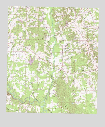
Hebron, MS USGS Topographic Map
Click on map above to begin viewing in our Map Viewer.

This topographic map contains these locations and features:
Feature Name Type Latitude Longitude GNIS ID View Map
Big CreekStreamN31.6393°W89.3234°667099View Map
Big Creek CemeteryCemeteryN31.6771°W89.3084°707334View Map
Big Creek ChurchChurchN31.6785°W89.3103°667107View Map
Big Creek Church (historical)ChurchN31.6502°W89.3123°685454View Map
Big Creek Watershed Structure 9 DamDamN31.7202°W89.3167°680848View Map
Boggy Volunteer Fire DepartmentBuildingN31.6351°W89.3630°2667882View Map
Bruce School (historical)SchoolN31.6988°W89.3001°685458View Map
C F Greene Lake DamDamN31.7318°W89.3034°680860View Map
Centerville Baptist ChurchChurchN31.6607°W89.3409°668269View Map
Centerville School (historical)SchoolN31.6602°W89.3398°685464View Map
Centreville CemeteryCemeteryN31.6604°W89.3412°707338View Map
Charles Pickering Catfish Ponds DamDamN31.6752°W89.3667°680820View Map
Deadman BranchStreamN31.6846°W89.2981°669170View Map
Deavor Powell Pond DamDamN31.7268°W89.3634°680854View Map
Deep BranchStreamN31.6918°W89.3101°669190View Map
Dry BranchStreamN31.6496°W89.3353°669400View Map
Duck Hill ChurchChurchN31.7352°W89.2703°669471View Map
Ellzey CemeteryCemeteryN31.6448°W89.3079°679430View Map
Harper BranchStreamN31.7060°W89.3109°670948View Map
Harper CemeteryCemeteryN31.7427°W89.3287°670952View Map
HebronPopulated PlaceN31.7063°W89.3709°671060View Map
Hebron CemeteryCemeteryN31.7032°W89.3698°707354View Map
Hebron Methodist ChurchChurchN31.7041°W89.3695°707356View Map
Hebron School (historical)SchoolN31.7029°W89.3712°707357View Map
Hebron Volunteer Fire DepartmentBuildingN31.7046°W89.3701°2668012View Map
Hill CemeteryCemeteryN31.7068°W89.2659°671207View Map
Liberty Church (historical)ChurchN31.6710°W89.3420°685525View Map
Little CreekStreamN31.6402°W89.3328°672579View Map
Mahaw BranchStreamN31.6971°W89.2984°673087View Map
Martin CreekStreamN31.6252°W89.3126°691580View Map
Merrill Pickering Lake DamDamN31.7252°W89.3584°680852View Map
Mill CreekStreamN31.6791°W89.3112°673602View Map
Morning Star ChurchChurchN31.6935°W89.3590°673827View Map
Mount Roe School (historical)SchoolN31.7263°W89.2667°685544View Map
Mount William ChurchChurchN31.7329°W89.3398°674314View Map
Polecat BranchStreamN31.7052°W89.3117°676179View Map
Prospect School (historical)SchoolN31.7435°W89.3734°685573View Map
Reed Brake BranchStreamN31.7157°W89.3140°676559View Map
Smiths Store (historical)LocaleN31.7346°W89.2842°685595View Map
South Fork Mill CreekStreamN31.6796°W89.2867°677997View Map
Supervisor District 2CivilN31.7228°W89.2824°711920View Map
Sweet Beulah ChurchChurchN31.7066°W89.2589°678464View Map
Trinity ChurchChurchN31.6643°W89.3603°678882View Map

Note: Coordinates in the location and feature list above are referenced to NAD83 datum.


Copyright (C) 2008-2024 Ryan Niemi / Sunset Dynamics ... All Rights Reserved