TopoQuest Logo
Do you find TopoQuest useful?
Help keep TopoQuest running and adding new maps/features by donating!
Bitcoin:  19c7KJd3qBynnjoSw5npx9KScwjBe4ifkT
Litecoin:  LXs6TkuXGGXo1vDsWCkWVdjQX94eUKd6ui
Home View Maps Find Maps Find Places Resources & Links


Henderson, Minnesota Topographic Map

USGS Map Title: Henderson, MN
USGS Map MRC: 44093E8
DRG (GeoTIFF) Download: o44093e8.tif


Neighboring USGS Topographic Map Quads:


  Green Isle, MN  
44094F1
 

  Hamburg, MN  
44093F8
 

  Belle Plaine North, MN  
44093F7
 

  Arlington, MN  
44094E1
 

  Henderson, MN  
44093E8
 

  Belle Plaine South, MN  
44093E7
 

  Norseland, MN  
44094D1
 

  Le Sueur, MN  
44093D8
 

  Saint Thomas, MN  
44093D7


Map MRC Location:

N45°
W94°
N45°
W93°
H8 H7 H6 H5 H4 H3 H2 H1
G8 G7 G6 G5 G4 G3 G2 G1
F8 F7 F6 F5 F4 F3 F2 F1
E8 E7 E6 E5 E4 E3 E2 E1
D8 D7 D6 D5 D4 D3 D2 D1
C8 C7 C6 C5 C4 C3 C2 C1
B8 B7 B6 B5 B4 B3 B2 B1
A8 A7 A6 A5 A4 A3 A2 A1
N44°
W94°
N44°
W93°

Henderson, MN USGS 1:24K Topographic Map Preview:
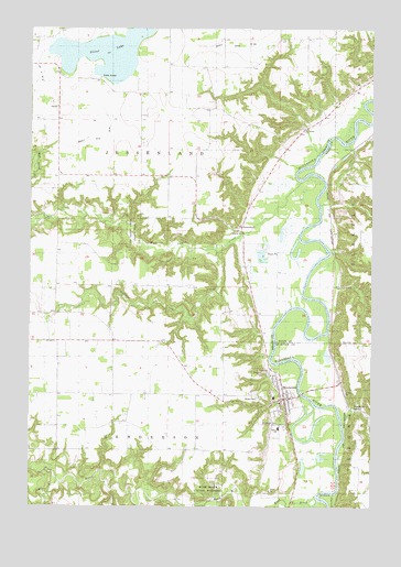
Henderson, MN USGS Topographic Map
Click on map above to begin viewing in our Map Viewer.

This topographic map contains these locations and features:
Feature Name Type Latitude Longitude GNIS ID View Map
Allansons ParkPopulated PlaceN44.5283°W93.9075°2065072View Map
Brown CemeteryCemeteryN44.5283°W93.9169°1817685View Map
Buffalo CreekStreamN44.5677°W93.9336°640608View Map
Centennial Lutheran ChurchChurchN44.5344°W93.9117°2065095View Map
City of HendersonCivilN44.5279°W93.9090°2394347View Map
County Ditch Number FortyfiveCanalN44.5964°W93.9725°1817689View Map
County Ditch Number Thirty ACanalN44.6208°W93.9308°1817687View Map
HendersonPopulated PlaceN44.5283°W93.9077°644862View Map
Henderson Fire DepartmentBuildingN44.5298°W93.9070°2666577View Map
Henderson Jehovahs WitnessesChurchN44.5242°W93.9117°2065094View Map
Henderson Police DepartmentBuildingN44.5284°W93.9091°2065090View Map
Henderson Post OfficePost OfficeN44.5278°W93.9069°2065091View Map
Henderson Public LibraryBuildingN44.5272°W93.9078°2065087View Map
Henderson StationLocaleN44.5258°W93.8839°644864View Map
High Island CreekStreamN44.5855°W93.9014°644939View Map
High Island CreekReservoirN44.5750°W93.9952°1777194View Map
High Island Creek County ParkParkN44.5714°W93.9641°1817688View Map
High Island Creek DamDamN44.5750°W93.9952°1777193View Map
Hilltop SchoolSchoolN44.5205°W93.9091°1817683View Map
Jessen Land Post Office (historical)Post OfficeN44.5719°W93.9231°2065108View Map
JessenlandPopulated PlaceN44.5719°W93.9233°645636View Map
Joseph R Brown State MonumentParkN44.5283°W93.9167°2065188View Map
Minnesota New Country SchoolSchoolN44.5283°W93.9031°2065096View Map
Rush RiverStreamN44.5002°W93.8980°650415View Map
Rush River State WaysideParkN44.5036°W93.9341°1817686View Map
Saint Joseph CemeteryCemeteryN44.5222°W93.9091°1817684View Map
Saint Joseph ParishChurchN44.5258°W93.9081°2065093View Map
Saint Paul's United Church of ChristChurchN44.5272°W93.9083°2065092View Map
Saint Thomas CemeteryCemeteryN44.5994°W93.9009°2065079View Map
Saint Thomas ChurchChurchN44.5994°W93.9002°651071View Map
Sibley County Historical MuseumBuildingN44.5278°W93.9094°2065089View Map
Sibley Estates EastPopulated PlaceN44.5278°W93.9092°2065088View Map
Silver LakeLakeN44.6185°W93.9734°652060View Map
South Branch Rush RiverStreamN44.5066°W93.9900°652276View Map
Township of HendersonCivilN44.5012°W93.9570°664447View Map
Township of JessenlandCivilN44.5874°W93.9524°664581View Map

Note: Coordinates in the location and feature list above are referenced to NAD83 datum.


Copyright (C) 2008-2025 Ryan Niemi / Sunset Dynamics ... All Rights Reserved