TopoQuest Logo
Do you find TopoQuest useful?
Help keep TopoQuest running and adding new maps/features by donating!
Bitcoin:  19c7KJd3qBynnjoSw5npx9KScwjBe4ifkT
Litecoin:  LXs6TkuXGGXo1vDsWCkWVdjQX94eUKd6ui
Home View Maps Find Maps Find Places Resources & Links


Henrietta, Tennessee Topographic Map

USGS Map Title: Henrietta, TN
USGS Map MRC: 36087D2
DRG (GeoTIFF) Download: o36087d2.tif


Neighboring USGS Topographic Map Quads:


  Clarksville, TN  
36087E3
 

  Sango, TN  
36087E2
 

  Adams, TN  
36087E1
 

  Excell, TN  
36087D3
 

  Henrietta, TN  
36087D2
 

  Pleasant View, TN  
36087D1
 

  Cumberland Furnace, TN  
36087C3
 

  Cheatham Dam, TN  
36087C2
 

  Ashland City, TN  
36087C1


Map MRC Location:

N37°
W88°
N37°
W87°
H8 H7 H6 H5 H4 H3 H2 H1
G8 G7 G6 G5 G4 G3 G2 G1
F8 F7 F6 F5 F4 F3 F2 F1
E8 E7 E6 E5 E4 E3 E2 E1
D8 D7 D6 D5 D4 D3 D2 D1
C8 C7 C6 C5 C4 C3 C2 C1
B8 B7 B6 B5 B4 B3 B2 B1
A8 A7 A6 A5 A4 A3 A2 A1
N36°
W88°
N36°
W87°

Henrietta, TN USGS 1:24K Topographic Map Preview:
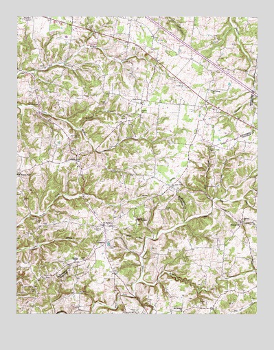
Henrietta, TN USGS Topographic Map
Click on map above to begin viewing in our Map Viewer.

This topographic map contains these locations and features:
Feature Name Type Latitude Longitude GNIS ID View Map
Adkins CemeteryCemeteryN36.3962°W87.2233°1275485View Map
Albright CemeteryCemeteryN36.4637°W87.2042°1275525View Map
Batts CemeteryCemeteryN36.4064°W87.2036°1326227View Map
Bearden CemeteryCemeteryN36.4231°W87.2461°1276646View Map
Bethel Baptist Church CemeteryCemeteryN36.4595°W87.1850°1953362View Map
Bethel Freewill Baptist ChurchChurchN36.4595°W87.1847°1305151View Map
Blanton CemeteryCemeteryN36.3848°W87.2397°1277671View Map
Blue SpringSpringN36.4237°W87.2175°1311462View Map
Buffalo CreekStreamN36.4234°W87.1322°1310763View Map
Commissioner District 3CivilN36.4692°W87.2042°2464180View Map
Council CemeteryCemeteryN36.3809°W87.1814°1326236View Map
Crotzer CemeteryCemeteryN36.3817°W87.1278°1326237View Map
Denny-Nicholson CemeteryCemeteryN36.3945°W87.1778°1326238View Map
District 10 (historical)CivilN36.4500°W87.1583°1325934View Map
District 14 (historical)CivilN36.4001°W87.2250°1325938View Map
Douglas CemeteryCemeteryN36.4062°W87.1975°1326239View Map
East Montgomery Elementary SchoolSchoolN36.4914°W87.2245°1319622View Map
East Montgomery Volunteer Fire Service Station 18BuildingN36.4922°W87.2223°2653722View Map
Ferraraccio FieldAirportN36.4931°W87.1870°2675494View Map
FredoniaPopulated PlaceN36.4398°W87.2186°1284865View Map
Fredonia School (historical)SchoolN36.4370°W87.2183°1319636View Map
Gupton CemeteryCemeteryN36.4028°W87.2011°1286452View Map
Gupton CemeteryCemeteryN36.3889°W87.1897°1326244View Map
Head CemeteryCemeteryN36.4792°W87.1256°1644289View Map
HenriettaPopulated PlaceN36.4053°W87.2036°1287429View Map
Henrietta Volunteer Fire Department Station 1BuildingN36.4070°W87.2049°2654156View Map
Hewitt CemeteryCemeteryN36.3981°W87.1292°1326246View Map
Hickory PointPopulated PlaceN36.4339°W87.2481°1287614View Map
Hobson Nicholson CemeteryCemeteryN36.3928°W87.2003°1326247View Map
Hollis-Nanny CemeteryCemeteryN36.3909°W87.2342°1288077View Map
Hunter CemeteryCemeteryN36.4192°W87.1722°1288736View Map
Hunter CemeteryCemeteryN36.3898°W87.1722°1326249View Map
Jarrell CemeteryCemeteryN36.4134°W87.2336°1289306View Map
Link CemeteryCemeteryN36.4128°W87.1294°1326252View Map
Mallory ChurchChurchN36.4150°W87.1325°1306721View Map
Mallorys CemeteryCemeteryN36.4153°W87.1322°1326254View Map
McAdoo ChurchChurchN36.4634°W87.2392°1293065View Map
McAdoo School (historical)SchoolN36.4634°W87.2397°1319668View Map
Montgomery County HomeLocaleN36.4148°W87.1875°1319676View Map
Mount Carmel ChurchChurchN36.4692°W87.1486°1294593View Map
Mount Harmon ChurchChurchN36.4123°W87.2050°1294619View Map
Mount Hebron ChurchChurchN36.3764°W87.1644°1294628View Map
Nicholson CemeteryCemeteryN36.3842°W87.2172°1295736View Map
Nicholson CemeteryCemeteryN36.3928°W87.1383°1326257View Map
Nicholson CemeteryCemeteryN36.3795°W87.1383°1326258View Map
Oak PlainsPopulated PlaceN36.4292°W87.1692°1296155View Map
Pardue CemeteryCemeteryN36.3803°W87.1553°1306876View Map
Pardue CemeteryCemeteryN36.3978°W87.2147°1296764View Map
Permelie Nicholson CemeteryCemeteryN36.3925°W87.1992°1326262View Map
Power CemeteryCemeteryN36.4037°W87.1881°1326264View Map
Raccoon CreekStreamN36.3892°W87.1856°1298792View Map
Reynolds BranchStreamN36.4531°W87.2169°1299248View Map
Ruckman FieldAirportN36.4717°W87.1354°2675495View Map
Rush BranchStreamN36.4192°W87.1483°1300259View Map
Salem School (historical)SchoolN36.3984°W87.1800°1317218View Map
Shady GrovePopulated PlaceN36.4639°W87.1847°1315908View Map
Shady Grove School (historical)SchoolN36.4639°W87.1861°1319712View Map
Shearon CemeteryCemeteryN36.4292°W87.1461°1303552View Map
Smith CemeteryCemeteryN36.4139°W87.2392°1270641View Map
Smith CemeteryCemeteryN36.4967°W87.2103°1852284View Map
Sorghum BranchStreamN36.4239°W87.1444°1270824View Map
Stack CemeteryCemeteryN36.4453°W87.1489°1303782View Map
Stack CemeteryCemeteryN36.4409°W87.1342°1326265View Map
Stewart CemeteryCemeteryN36.3762°W87.1872°1271366View Map
ThomasvillePopulated PlaceN36.4139°W87.1336°1272500View Map
Wall CemeteryCemeteryN36.4500°W87.2214°1273658View Map
Waltons ChapelChurchN36.3973°W87.2189°1273757View Map
Wilson CemeteryCemeteryN36.3814°W87.1606°1326271View Map
Woodall CemeteryCemeteryN36.4109°W87.2064°1275024View Map
Woodford (historical)Populated PlaceN36.4917°W87.1792°1311574View Map

Note: Coordinates in the location and feature list above are referenced to NAD83 datum.


Copyright (C) 2008-2024 Ryan Niemi / Sunset Dynamics ... All Rights Reserved