TopoQuest Logo
Do you find TopoQuest useful?
Help keep TopoQuest running and adding new maps/features by donating!
Bitcoin:  19c7KJd3qBynnjoSw5npx9KScwjBe4ifkT
Litecoin:  LXs6TkuXGGXo1vDsWCkWVdjQX94eUKd6ui
Home View Maps Find Maps Find Places Resources & Links


Arlington, Georgia Topographic Map

USGS Map Title: Arlington, GA
USGS Map MRC: 31084D6
DRG (GeoTIFF) Download: o31084d6.tif


Neighboring USGS Topographic Map Quads:


  Bluffton, GA  
31084E7
 

  Edison, GA  
31084E6
 

  Morgan, GA  
31084E5
 

  Bancroft, GA  
31084D7
 

  Arlington, GA  
31084D6
 

  Leary, GA  
31084D5
 

  Hentown, GA  
31084C7
 

  Damascus, GA  
31084C6
 

  Bethany, GA  
31084C5


Map MRC Location:

N32°
W85°
N32°
W84°
H8 H7 H6 H5 H4 H3 H2 H1
G8 G7 G6 G5 G4 G3 G2 G1
F8 F7 F6 F5 F4 F3 F2 F1
E8 E7 E6 E5 E4 E3 E2 E1
D8 D7 D6 D5 D4 D3 D2 D1
C8 C7 C6 C5 C4 C3 C2 C1
B8 B7 B6 B5 B4 B3 B2 B1
A8 A7 A6 A5 A4 A3 A2 A1
N31°
W85°
N31°
W84°

Arlington, GA USGS 1:24K Topographic Map Preview:
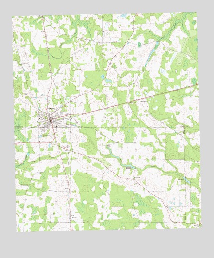
Arlington, GA USGS Topographic Map
Click on map above to begin viewing in our Map Viewer.

This topographic map contains these locations and features:
Feature Name Type Latitude Longitude GNIS ID View Map
Andrews AirportAirportN31.4133°W84.7130°351658View Map
ArlingtonPopulated PlaceN31.4399°W84.7249°310614View Map
Arlington Baptist ChurchChurchN31.4368°W84.7241°335051View Map
Arlington ChurchChurchN31.4246°W84.7210°310616View Map
Arlington DivisionCivilN31.4728°W84.7421°1936084View Map
Arlington Elementary SchoolSchoolN31.4402°W84.7327°335052View Map
Arlington Methodist Episcopal ChurchChurchN31.4391°W84.7274°335445View Map
Arlington Police DepartmentBuildingN31.4404°W84.7239°2733829View Map
Arlington Post OfficePost OfficeN31.4395°W84.7260°352091View Map
Arlington Volunteer Fire DepartmentBuildingN31.4334°W84.7233°2603915View Map
Calhoun County Elementary SchoolSchoolN31.4418°W84.7196°335054View Map
Calhoun Memorial HospitalHospitalN31.4360°W84.7217°335056View Map
City of ArlingtonCivilN31.4383°W84.7253°2403114View Map
Commissary HillPopulated PlaceN31.4499°W84.6660°326228View Map
Covington Mill (historical)LocaleN31.4105°W84.6691°344879View Map
Early County Fire Department Arlington StationBuildingN31.4335°W84.7232°2604164View Map
Gessemane Baptist ChurchChurchN31.4405°W84.7302°335446View Map
Hillside Church (historical)ChurchN31.3782°W84.6421°344902View Map
Hopewell ChurchChurchN31.4685°W84.6608°315642View Map
Jones SpurPopulated PlaceN31.4268°W84.6349°342838View Map
Jordans AirportAirportN31.4389°W84.7079°351657View Map
Kiokee ChurchChurchN31.4016°W84.6688°316465View Map
Mount Zion ChurchChurchN31.3813°W84.7110°318947View Map
Nancy SpringSpringN31.4232°W84.6871°319203View Map
New Point ChurchChurchN31.4852°W84.6988°319494View Map
New Prospect ChurchChurchN31.4018°W84.7416°319500View Map
NicholasvillePopulated PlaceN31.4041°W84.6699°326420View Map
Piney Grove ChurchChurchN31.3763°W84.6252°320699View Map
Rays PondReservoirN31.4028°W84.6342°321344View Map
RowenaPopulated PlaceN31.3810°W84.7130°332938View Map
Rue BranchStreamN31.4146°W84.7441°321990View Map
Saint Paul ChurchChurchN31.4355°W84.7299°322230View Map
Sheffield MillpondReservoirN31.4120°W84.6737°322825View Map
Sheffield Millpond DamDamN31.4118°W84.6716°342156View Map
Thomas Grove ChurchChurchN31.4724°W84.7438°324082View Map
Timmons CemeteryCemeteryN31.4090°W84.7349°324184View Map
Zion Hill ChurchChurchN31.3805°W84.7019°325691View Map

Note: Coordinates in the location and feature list above are referenced to NAD83 datum.


Copyright (C) 2008-2024 Ryan Niemi / Sunset Dynamics ... All Rights Reserved