TopoQuest Logo
Do you find TopoQuest useful?
Help keep TopoQuest running and adding new maps/features by donating!
Bitcoin:  19c7KJd3qBynnjoSw5npx9KScwjBe4ifkT
Litecoin:  LXs6TkuXGGXo1vDsWCkWVdjQX94eUKd6ui
Home View Maps Find Maps Find Places Resources & Links


Herrick, Illinois Topographic Map

USGS Map Title: Herrick, IL
USGS Map MRC: 39088B8
DRG (GeoTIFF) Download: o39088b8.tif


Neighboring USGS Topographic Map Quads:


  Oconee, IL  
39089C1
 

  Lakewood, IL  
39088C8
 

  Fancher, IL  
39088C7
 

  Ramsey, IL  
39089B1
 

  Herrick, IL  
39088B8
 

  Beecher City, IL  
39088B7
 

  Vera, IL  
39089A1
 

  Avena, IL  
39088A8
 

  Altamont West, IL  
39088A7


Map MRC Location:

N40°
W89°
N40°
W88°
H8 H7 H6 H5 H4 H3 H2 H1
G8 G7 G6 G5 G4 G3 G2 G1
F8 F7 F6 F5 F4 F3 F2 F1
E8 E7 E6 E5 E4 E3 E2 E1
D8 D7 D6 D5 D4 D3 D2 D1
C8 C7 C6 C5 C4 C3 C2 C1
B8 B7 B6 B5 B4 B3 B2 B1
A8 A7 A6 A5 A4 A3 A2 A1
N39°
W89°
N39°
W88°

Herrick, IL USGS 1:24K Topographic Map Preview:
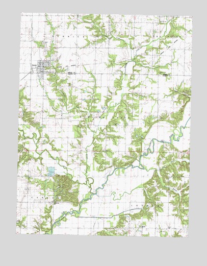
Herrick, IL USGS Topographic Map
Click on map above to begin viewing in our Map Viewer.

This topographic map contains these locations and features:
Feature Name Type Latitude Longitude GNIS ID View Map
Antioch CemeteryCemeteryN39.2098°W88.9619°403544View Map
Bacon BranchStreamN39.1620°W88.8987°403790View Map
Beck Private CemeteryCemeteryN39.2058°W88.9335°1736920View Map
Becks CreekStreamN39.1487°W88.9442°404081View Map
Blankenship CemeteryCemeteryN39.1430°W88.9731°404556View Map
Bowling Green TownhallBuildingN39.2017°W88.9448°1736927View Map
Buchanan CemeteryCemeteryN39.1867°W88.9551°1736931View Map
Dean HillsSummitN39.1495°W88.9637°407036View Map
Dean Hills Nature PreserveParkN39.1562°W88.9640°1994347View Map
Dial CemeteryCemeteryN39.1281°W88.8956°1736939View Map
Dunkard CemeteryCemeteryN39.1303°W88.9101°1802261View Map
Good Hope School (historical)SchoolN39.1873°W88.9145°409138View Map
HerrickPopulated PlaceN39.2203°W88.9845°410104View Map
Herrick Elementary SchoolSchoolN39.2239°W88.9845°1821172View Map
Herrick Fire DepartmentBuildingN39.2193°W88.9845°2681992View Map
Herrick Post OfficePost OfficeN39.2183°W88.9849°2788552View Map
Hog CreekStreamN39.1631°W88.9073°410349View Map
Hog Creek School (historical)SchoolN39.1595°W88.8895°410351View Map
Kaskaskia ChurchChurchN39.1300°W88.9090°411322View Map
Liberty School (historical)SchoolN39.1503°W88.9717°412015View Map
Lorton BridgeBridgeN39.1781°W88.8948°425144View Map
Lorton CemeteryCemeteryN39.1915°W88.8974°1736957View Map
Lorton Church (historical)ChurchN39.1914°W88.8992°412640View Map
Mitchell CreekStreamN39.1573°W88.9490°413687View Map
Mud Run CemeteryCemeteryN39.2460°W88.8982°1725300View Map
Mud Run School (historical)SchoolN39.2464°W88.9003°414197View Map
Myers CemeteryCemeteryN39.2331°W88.9834°413464View Map
Oak Grove CemeteryCemeteryN39.1884°W88.9305°1802273View Map
Oak Grove ChurchChurchN39.1878°W88.9303°414787View Map
Pint CreekStreamN39.1903°W88.9498°415723View Map
Pleasant Grove CemeteryCemeteryN39.2171°W88.8984°1725307View Map
Pleasant Grove School (historical)SchoolN39.2173°W88.8990°415801View Map
Pleasant Union School (historical)SchoolN39.2367°W88.9453°415895View Map
Polecat CreekStreamN39.2242°W88.9195°415984View Map
Prairie Union CemeteryCemeteryN39.2375°W88.9451°1821188View Map
Rogers CemeteryCemeteryN39.1300°W88.8898°1736987View Map
School Number 10 (historical)SchoolN39.1803°W88.9734°425455View Map
Section CreekStreamN39.1839°W88.9456°418179View Map
Shady Lane School (historical)SchoolN39.2098°W88.9398°418261View Map
Township of Bowling GreenCivilN39.1928°W88.9437°428700View Map
Township of CarsonCivilN39.1432°W88.9991°428769View Map
Township of HerrickCivilN39.2378°W88.9714°429131View Map
Township of LoudonCivilN39.1389°W88.8756°429283View Map
Valley School (historical)SchoolN39.1737°W88.9359°420206View Map
Victory School (historical)SchoolN39.1298°W88.8992°420296View Map
Village of HerrickCivilN39.2196°W88.9848°2398493View Map
Welch CemeteryCemeteryN39.1315°W88.9985°420718View Map
Wren BridgeBridgeN39.1300°W88.9737°425653View Map

Note: Coordinates in the location and feature list above are referenced to NAD83 datum.


Copyright (C) 2008-2025 Ryan Niemi / Sunset Dynamics ... All Rights Reserved