TopoQuest Logo
Do you find TopoQuest useful?
Help keep TopoQuest running and adding new maps/features by donating!
Bitcoin:  19c7KJd3qBynnjoSw5npx9KScwjBe4ifkT
Litecoin:  LXs6TkuXGGXo1vDsWCkWVdjQX94eUKd6ui
Home View Maps Find Maps Find Places Resources & Links


Beecher City, Illinois Topographic Map

USGS Map Title: Beecher City, IL
USGS Map MRC: 39088B7
DRG (GeoTIFF) Download: o39088b7.tif


Neighboring USGS Topographic Map Quads:


  Lakewood, IL  
39088C8
 

  Fancher, IL  
39088C7
 

  Stewardson West, IL  
39088C6
 

  Herrick, IL  
39088B8
 

  Beecher City, IL  
39088B7
 

  Shumway, IL  
39088B6
 

  Avena, IL  
39088A8
 

  Altamont West, IL  
39088A7
 

  Altamont East, IL  
39088A6


Map MRC Location:

N40°
W89°
N40°
W88°
H8 H7 H6 H5 H4 H3 H2 H1
G8 G7 G6 G5 G4 G3 G2 G1
F8 F7 F6 F5 F4 F3 F2 F1
E8 E7 E6 E5 E4 E3 E2 E1
D8 D7 D6 D5 D4 D3 D2 D1
C8 C7 C6 C5 C4 C3 C2 C1
B8 B7 B6 B5 B4 B3 B2 B1
A8 A7 A6 A5 A4 A3 A2 A1
N39°
W89°
N39°
W88°

Beecher City, IL USGS 1:24K Topographic Map Preview:
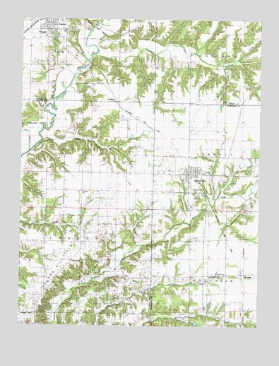
Beecher City, IL USGS Topographic Map
Click on map above to begin viewing in our Map Viewer.

This topographic map contains these locations and features:
Feature Name Type Latitude Longitude GNIS ID View Map
Beecher CemeteryCemeteryN39.1806°W88.7876°1810468View Map
Beecher CityPopulated PlaceN39.1881°W88.7867°404102View Map
Beecher City Grade SchoolSchoolN39.1884°W88.7839°1810469View Map
Beecher City Junior-Senior High SchoolSchoolN39.1887°W88.7967°1810470View Map
Beecher City Post OfficePost OfficeN39.1870°W88.7883°2788236View Map
Bob Doan CemeteryCemeteryN39.1914°W88.8231°1736923View Map
Bob Doane CemeteryCemeteryN39.1917°W88.8228°409431View Map
Brush CreekStreamN39.2362°W88.7840°405023View Map
Buzzard School (historical)SchoolN39.1792°W88.8609°405310View Map
Carter CampLocaleN39.1534°W88.8473°405647View Map
Carter Refinery (historical)LocaleN39.1442°W88.8570°424719View Map
Cary BranchStreamN39.2312°W88.7734°405668View Map
Corwin BranchStreamN39.1781°W88.7703°406604View Map
CowdenPopulated PlaceN39.2484°W88.8623°406681View Map
Cowden Bridge (historical)BridgeN39.2253°W88.8495°424787View Map
Cowden Elementary SchoolSchoolN39.2470°W88.8626°1821160View Map
Cowden-Herrick High SchoolSchoolN39.2431°W88.8628°1725253View Map
Fanny BranchStreamN39.2012°W88.8656°408267View Map
Gossage BranchStreamN39.1781°W88.7576°409209View Map
Greenland (historical)Populated PlaceN39.1798°W88.8195°1773074View Map
Greenland ChurchChurchN39.1795°W88.8417°409432View Map
Greenland School (historical)SchoolN39.1792°W88.8198°409433View Map
HollidayPopulated PlaceN39.2164°W88.8248°410396View Map
Hubbartt CemeteryCemeteryN39.2167°W88.7702°1725272View Map
Hubbartt Church (historical)ChurchN39.2178°W88.7701°410642View Map
Logue School (historical)SchoolN39.1262°W88.8231°412526View Map
Loudon Oil FieldOilfieldN39.1417°W88.8334°1736959View Map
Memorial Gardens CemeteryCemeteryN39.1806°W88.7862°1725658View Map
Miller School (historical)SchoolN39.1598°W88.8415°413592View Map
MoccasinPopulated PlaceN39.1473°W88.7578°413693View Map
Moccasin CemeteryCemeteryN39.1464°W88.7670°1725659View Map
Oakland School (historical)SchoolN39.2484°W88.8151°414897View Map
Petty BranchStreamN39.1962°W88.8715°415594View Map
Pleasant Grove CemeteryCemeteryN39.1453°W88.7770°1725660View Map
Pleasant Hill School (historical)SchoolN39.1589°W88.7856°415841View Map
Prairie Union School (historical)SchoolN39.2170°W88.7867°416169View Map
Ransom ChurchChurchN39.1656°W88.8284°416390View Map
Ranson CemeteryCemeteryN39.1660°W88.8288°1736984View Map
Richland CreekStreamN39.2359°W88.8365°416606View Map
Tipsword CemeteryCemeteryN39.1728°W88.7779°1725663View Map
Township of Dry PointCivilN39.2455°W88.8614°428914View Map
Tri - County Fire Station of Beecher CityBuildingN39.1869°W88.7866°2681737View Map
Village of Beecher CityCivilN39.1867°W88.7876°2398067View Map
Village of CowdenCivilN39.2492°W88.8594°2398639View Map
Wrights CornerPopulated PlaceN39.1295°W88.8665°423339View Map

Note: Coordinates in the location and feature list above are referenced to NAD83 datum.


Copyright (C) 2008-2025 Ryan Niemi / Sunset Dynamics ... All Rights Reserved