TopoQuest Logo
Do you find TopoQuest useful?
Help keep TopoQuest running and adding new maps/features by donating!
Bitcoin:  19c7KJd3qBynnjoSw5npx9KScwjBe4ifkT
Litecoin:  LXs6TkuXGGXo1vDsWCkWVdjQX94eUKd6ui
Home View Maps Find Maps Find Places Resources & Links


Hiattsville, Iowa Topographic Map

USGS Map Title: Hiattsville, IA
USGS Map MRC: 40092G7
DRG (GeoTIFF) Download: o40092g7.tif


Neighboring USGS Topographic Map Quads:


  Iconium, IA  
40092H8
 

  Moravia, IA  
40092H7
 

  Blakesburg, IA  
40092H6
 

  Mystic, IA  
40092G8
 

  Hiattsville, IA  
40092G7
 

  Unionville, IA  
40092G6
 

  Centerville West, IA  
40092F8
 

  Centerville East, IA  
40092F7
 

  Moulton, IA  
40092F6


Map MRC Location:

N41°
W93°
N41°
W92°
H8 H7 H6 H5 H4 H3 H2 H1
G8 G7 G6 G5 G4 G3 G2 G1
F8 F7 F6 F5 F4 F3 F2 F1
E8 E7 E6 E5 E4 E3 E2 E1
D8 D7 D6 D5 D4 D3 D2 D1
C8 C7 C6 C5 C4 C3 C2 C1
B8 B7 B6 B5 B4 B3 B2 B1
A8 A7 A6 A5 A4 A3 A2 A1
N40°
W93°
N40°
W92°

Hiattsville, IA USGS 1:24K Topographic Map Preview:
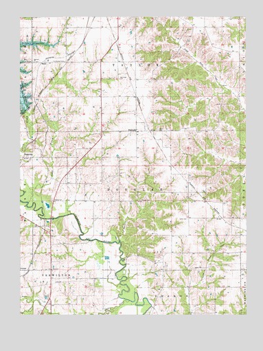
Hiattsville, IA USGS Topographic Map
Click on map above to begin viewing in our Map Viewer.

This topographic map contains these locations and features:
Feature Name Type Latitude Longitude GNIS ID View Map
Bryant CemeteryCemeteryN40.7978°W92.8080°454903View Map
Buck Creek ParkParkN40.8472°W92.8738°1970250View Map
Centerville Medical ClinicHospitalN40.7514°W92.8627°1970251View Map
Cooper CreekStreamN40.7558°W92.8149°455618View Map
Dale CemeteryCemeteryN40.7696°W92.8577°455774View Map
DarbyvillePopulated PlaceN40.8161°W92.8733°455793View Map
Darbyville Post Office (historical)Post OfficeN40.8161°W92.8733°1970159View Map
Dennis (historical)LocaleN40.8161°W92.8627°466383View Map
Dennis Post Office (historical)Post OfficeN40.7872°W92.8585°466530View Map
Denny CemeteryCemeteryN40.8275°W92.7987°455883View Map
Fairview CemeteryCemeteryN40.8562°W92.8674°1970318View Map
Fairview ChurchChurchN40.8561°W92.8671°456504View Map
Haynes CemeteryCemeteryN40.7981°W92.8574°457353View Map
HiattsvillePopulated PlaceN40.8272°W92.8105°457417View Map
Hiattsville Post Office (historical)Post OfficeN40.8272°W92.8105°1970160View Map
MainePopulated PlaceN40.8561°W92.8616°464639View Map
Maine (historical)LocaleN40.8556°W92.8641°1970158View Map
Martin CemeteryCemeteryN40.8056°W92.7835°1970304View Map
Mercy Medical Center CentervilleHospitalN40.7557°W92.8569°1970252View Map
New Hope CemeteryCemeteryN40.8492°W92.8203°459478View Map
Outlet ParkParkN40.8181°W92.8696°1975661View Map
Perjue CemeteryCemeteryN40.7611°W92.7585°1975657View Map
Rathbun DamDamN40.8353°W92.8702°460533View Map
Rathbun Fish HatcheryLocaleN40.8306°W92.8738°1975659View Map
Rathbun Lake Airport (historical)AirportN40.8517°W92.8585°466740View Map
Rathbun Research CenterBuildingN40.8306°W92.8738°1975660View Map
Ray Post Office (historical)Post OfficeN40.8556°W92.8641°1970157View Map
Saint Josephs Mercy Medical ClinicHospitalN40.7514°W92.8627°1970253View Map
Salem CemeteryCemeteryN40.7902°W92.7826°461355View Map
Snort CreekStreamN40.7814°W92.8202°461726View Map
Snyder BranchStreamN40.7970°W92.8708°461729View Map
Township of DouglasCivilN40.8003°W92.8058°467723View Map
Township of TaylorCivilN40.8628°W92.8112°468782View Map

Note: Coordinates in the location and feature list above are referenced to NAD83 datum.


Copyright (C) 2008-2024 Ryan Niemi / Sunset Dynamics ... All Rights Reserved