TopoQuest Logo
Do you find TopoQuest useful?
Help keep TopoQuest running and adding new maps/features by donating!
Bitcoin:  19c7KJd3qBynnjoSw5npx9KScwjBe4ifkT
Litecoin:  LXs6TkuXGGXo1vDsWCkWVdjQX94eUKd6ui
Home View Maps Find Maps Find Places Resources & Links


Mystic, Iowa Topographic Map

USGS Map Title: Mystic, IA
USGS Map MRC: 40092G8
DRG (GeoTIFF) Download: o40092g8.tif


Neighboring USGS Topographic Map Quads:


  Melrose, IA  
40093H1
 

  Iconium, IA  
40092H8
 

  Moravia, IA  
40092H7
 

  Plano, IA  
40093G1
 

  Mystic, IA  
40092G8
 

  Hiattsville, IA  
40092G7
 

  Seymour East, IA  
40093F1
 

  Centerville West, IA  
40092F8
 

  Centerville East, IA  
40092F7


Map MRC Location:

N41°
W93°
N41°
W92°
H8 H7 H6 H5 H4 H3 H2 H1
G8 G7 G6 G5 G4 G3 G2 G1
F8 F7 F6 F5 F4 F3 F2 F1
E8 E7 E6 E5 E4 E3 E2 E1
D8 D7 D6 D5 D4 D3 D2 D1
C8 C7 C6 C5 C4 C3 C2 C1
B8 B7 B6 B5 B4 B3 B2 B1
A8 A7 A6 A5 A4 A3 A2 A1
N40°
W93°
N40°
W92°

Mystic, IA USGS 1:24K Topographic Map Preview:
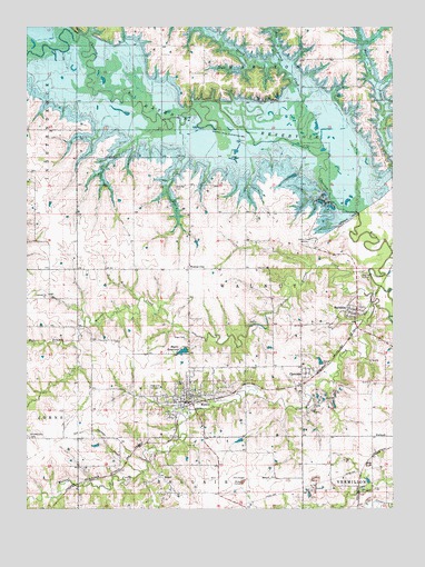
Mystic, IA USGS Topographic Map
Click on map above to begin viewing in our Map Viewer.

This topographic map contains these locations and features:
Feature Name Type Latitude Longitude GNIS ID View Map
Antioch CemeteryCemeteryN40.8633°W92.8974°1970293View Map
Bohm CemeteryCemeteryN40.8333°W92.9502°1970301View Map
BrazilLocaleN40.7581°W92.9544°1970184View Map
BrazilPopulated PlaceN40.7581°W92.9544°454810View Map
Brazil Post Office (historical)Post OfficeN40.7581°W92.9544°1970183View Map
Buck BranchStreamN40.8070°W92.8758°454913View Map
Calhoun Post Office (historical)Post OfficeN40.8736°W92.9544°1970166View Map
City of MysticCivilN40.7792°W92.9446°2395146View Map
City of RathbunCivilN40.8017°W92.8871°2396323View Map
ClarkdaleLocaleN40.7820°W92.9066°1970181View Map
ClarkdalePopulated PlaceN40.7853°W92.9049°455434View Map
Clarkdale Post Office (historical)Post OfficeN40.7853°W92.9049°1970182View Map
Community Church of MysticChurchN40.7775°W92.9438°1970273View Map
Concord CemeteryCemeteryN40.8047°W92.9931°1970312View Map
Concord ChurchChurchN40.8047°W92.9941°455564View Map
DiamondPopulated PlaceN40.7631°W92.9658°464331View Map
Diamond Post Office (historical)Post OfficeN40.7631°W92.9658°1970177View Map
Elgin CemeteryCemeteryN40.7948°W92.9456°456275View Map
First Christian ChurchChurchN40.7775°W92.9438°1970268View Map
Fleenor CemeteryCemeteryN40.8639°W92.8974°1970294View Map
ForbushPopulated PlaceN40.7689°W92.8771°464548View Map
Forbush (historical)LocaleN40.7667°W92.8780°1970176View Map
Forbush CemeteryCemeteryN40.7720°W92.8779°1970311View Map
Forbush Post Office (historical)Post OfficeN40.7689°W92.8771°1970175View Map
Garfield CemeteryCemeteryN40.7751°W92.9919°1970310View Map
Ham BranchStreamN40.8656°W92.9135°457212View Map
Highland CemeteryCemeteryN40.7809°W92.9590°457455View Map
Honey CreekStreamN40.8453°W92.9035°457610View Map
Honey Creek State ParkParkN40.8611°W92.9363°1970254View Map
Island View ParkParkN40.8472°W92.9169°1970248View Map
KMGO-FM (Centerville)TowerN40.7928°W92.8799°463689View Map
Little Walnut CreekStreamN40.8033°W92.8808°458526View Map
MysticLocaleN40.7778°W92.9419°1970274View Map
MysticPopulated PlaceN40.7775°W92.9438°459427View Map
Mystic City HallBuildingN40.7775°W92.9438°1970269View Map
Mystic Elementary SchoolSchoolN40.7863°W92.9386°1970270View Map
Mystic Fire DepartmentBuildingN40.7853°W92.9451°1970271View Map
Mystic First ResponderBuildingN40.7853°W92.9452°2599833View Map
Mystic Post OfficePost OfficeN40.7775°W92.9438°1970272View Map
Mystic ReservoirReservoirN40.7910°W92.9468°459428View Map
Philadelphia CemeteryCemeteryN40.7687°W92.9997°460112View Map
Prairie Ridge ParkParkN40.8500°W92.8808°1970249View Map
RathbunPopulated PlaceN40.8011°W92.8888°460531View Map
RathbunLocaleN40.7981°W92.8874°1970179View Map
Rathbun Post Office (historical)Post OfficeN40.8011°W92.8888°1970180View Map
Rolling Cove ParkParkN40.8486°W92.9808°1970247View Map
Shaeffer CemeteryCemeteryN40.8339°W92.9496°461522View Map
Township of CharitonCivilN40.8701°W92.9218°467590View Map
Township of WalnutCivilN40.8064°W92.9287°468882View Map
Walnut CityPopulated PlaceN40.8122°W92.9449°464790View Map
Walnut City Post Office (historical)Post OfficeN40.8122°W92.9449°1970178View Map
Walnut CreekStreamN40.8003°W92.8760°462633View Map
Wolf BranchStreamN40.7931°W92.9846°463152View Map
Zimmer CemeteryCemeteryN40.8167°W92.9339°1970300View Map

Note: Coordinates in the location and feature list above are referenced to NAD83 datum.


Copyright (C) 2008-2025 Ryan Niemi / Sunset Dynamics ... All Rights Reserved