TopoQuest Logo
Do you find TopoQuest useful?
Help keep TopoQuest running and adding new maps/features by donating!
Bitcoin:  19c7KJd3qBynnjoSw5npx9KScwjBe4ifkT
Litecoin:  LXs6TkuXGGXo1vDsWCkWVdjQX94eUKd6ui
Home View Maps Find Maps Find Places Resources & Links


Centerville West, Iowa Topographic Map

USGS Map Title: Centerville West, IA
USGS Map MRC: 40092F8
DRG (GeoTIFF) Download: o40092f8.tif


Neighboring USGS Topographic Map Quads:


  Plano, IA  
40093G1
 

  Mystic, IA  
40092G8
 

  Hiattsville, IA  
40092G7
 

  Seymour East, IA  
40093F1
 

  Centerville West, IA  
40092F8
 

  Centerville East, IA  
40092F7
 

  Lake Thunderhead, MO  
40093E1
 

  Mendota, MO  
40092E8
 

  Omaha, MO  
40092E7


Map MRC Location:

N41°
W93°
N41°
W92°
H8 H7 H6 H5 H4 H3 H2 H1
G8 G7 G6 G5 G4 G3 G2 G1
F8 F7 F6 F5 F4 F3 F2 F1
E8 E7 E6 E5 E4 E3 E2 E1
D8 D7 D6 D5 D4 D3 D2 D1
C8 C7 C6 C5 C4 C3 C2 C1
B8 B7 B6 B5 B4 B3 B2 B1
A8 A7 A6 A5 A4 A3 A2 A1
N40°
W93°
N40°
W92°

Centerville West, IA USGS 1:24K Topographic Map Preview:
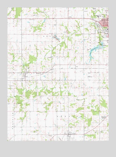
Centerville West, IA USGS Topographic Map
Click on map above to begin viewing in our Map Viewer.

This topographic map contains these locations and features:
Feature Name Type Latitude Longitude GNIS ID View Map
Adamson CemeteryCemeteryN40.6659°W92.9585°1970319View Map
Apostolic Pentecostal ChurchChurchN40.7370°W92.8877°1970220View Map
Appanoose Country ClubLocaleN40.7489°W92.8946°1823288View Map
Appanoose County FarmLocaleN40.7258°W92.9446°1823289View Map
Appanoose County Sheriff's OfficeBuildingN40.7353°W92.8857°1970190View Map
Baker CemeteryCemeteryN40.7473°W92.9337°1970321View Map
Bellair (historical)Populated PlaceN40.6917°W92.9794°467222View Map
Bellair Post Office (historical)Post OfficeN40.6917°W92.9794°1970185View Map
Bradley ParkParkN40.7145°W92.8849°1823285View Map
Centerville Center LibraryBuildingN40.7411°W92.8877°1970187View Map
Centerville Family Care CenterHospitalN40.7322°W92.8758°1970202View Map
Centerville Gospel ChapelChurchN40.7270°W92.8755°1970222View Map
Centerville High SchoolSchoolN40.7290°W92.8763°1970228View Map
Centerville Municipal AirportAirportN40.6888°W92.9013°466739View Map
Centerville Post OfficePost OfficeN40.7345°W92.8766°1970189View Map
CincinnatiPopulated PlaceN40.6308°W92.9246°455415View Map
Cincinnati (historical)LocaleN40.6306°W92.9246°1970290View Map
Cincinnati City HallBuildingN40.6308°W92.9246°1970289View Map
Cincinnati Elementary SchoolSchoolN40.6329°W92.9242°1970291View Map
Cincinnati Post OfficePost OfficeN40.6308°W92.9246°1970286View Map
Cincinnati Volunteer Fire DepartmentBuildingN40.6307°W92.9257°2577256View Map
City of CincinnatiCivilN40.6309°W92.9222°2393525View Map
City of NumaCivilN40.6854°W92.9800°2395280View Map
County Farm CemeteryCemeteryN40.7333°W92.9502°1970320View Map
Dale Baptist ChurchChurchN40.7311°W92.8846°1970221View Map
Dora Barnes Residential HomeHospitalN40.7364°W92.8769°1970199View Map
East Pleasant Church of ChristChurchN40.6308°W92.9246°1970288View Map
Evergreen CemeteryCemeteryN40.6379°W92.9240°456419View Map
Faith United ParishChurchN40.6308°W92.9246°1970287View Map
Farmers CemeteryCemeteryN40.6766°W92.9965°456546View Map
Felkner CemeteryCemeteryN40.7386°W92.9730°456565View Map
First Baptist ChurchChurchN40.7347°W92.8791°1970217View Map
Grace Tabernacle Baptist ChurchChurchN40.7431°W92.8780°1970203View Map
Heritage Christian SchoolSchoolN40.7431°W92.8780°1970226View Map
HibbsvilleLocaleN40.6597°W92.9919°466387View Map
Hibbsville CemeteryCemeteryN40.6601°W92.9869°457419View Map
Hibbsville Post Office (historical)Post OfficeN40.6597°W92.9919°1970169View Map
Howar Junior High SchoolSchoolN40.7252°W92.8765°1823286View Map
Indian Hills Community College Centerville CampusSchoolN40.7402°W92.8876°1823287View Map
KCOG-AM (Centerville)TowerN40.7445°W92.9091°467010View Map
Lakeview Elementary SchoolSchoolN40.7174°W92.8764°1970230View Map
Lincoln Elementary SchoolSchoolN40.7382°W92.8759°1970229View Map
Livengood CemeteryCemeteryN40.7031°W92.9452°458535View Map
Lower City ReservoirReservoirN40.7145°W92.8832°1823284View Map
Manson BranchStreamN40.7345°W92.8958°458763View Map
MartinstownPopulated PlaceN40.6872°W92.9591°464643View Map
Morrison CemeteryCemeteryN40.6306°W92.8946°1970302View Map
Motto CemeteryCemeteryN40.6745°W92.9355°459265View Map
NumaPopulated PlaceN40.6881°W92.9780°459679View Map
Numa (historical)LocaleN40.6833°W92.9780°1970168View Map
Numa CemeteryCemeteryN40.6931°W92.9760°459680View Map
Numa Post Office (historical)Post OfficeN40.6881°W92.9780°1970167View Map
Open Bible ChurchChurchN40.7347°W92.8816°1970218View Map
Pleasant Hill CemeteryCemeteryN40.6295°W92.9444°460236View Map
Porter CemeteryCemeteryN40.6744°W92.8778°1823281View Map
StreepyPopulated PlaceN40.6961°W92.9160°464764View Map
SunshinePopulated PlaceN40.7397°W92.9252°462120View Map
Thomas CemeteryCemeteryN40.7107°W92.9019°1823282View Map
Township of BellairCivilN40.7252°W92.9444°467431View Map
Township of PleasantCivilN40.6347°W92.9251°468527View Map
Upper City ReservoirReservoirN40.7122°W92.8899°1823283View Map
White CemeteryCemeteryN40.6333°W92.9634°462976View Map

Note: Coordinates in the location and feature list above are referenced to NAD83 datum.


Copyright (C) 2008-2025 Ryan Niemi / Sunset Dynamics ... All Rights Reserved