TopoQuest Logo
Do you find TopoQuest useful?
Help keep TopoQuest running and adding new maps/features by donating!
Bitcoin:  19c7KJd3qBynnjoSw5npx9KScwjBe4ifkT
Litecoin:  LXs6TkuXGGXo1vDsWCkWVdjQX94eUKd6ui
Home View Maps Find Maps Find Places Resources & Links


Hickory, Mississippi Topographic Map

USGS Map Title: Hickory, MS
USGS Map MRC: 32089C1
DRG (GeoTIFF) Download: o32089c1.tif


Neighboring USGS Topographic Map Quads:


  Decatur NW, MS  
32089D2
 

  Decatur, MS  
32089D1
 

  Duffee, MS  
32088D8
 

  Newton, MS  
32089C2
 

  Hickory, MS  
32089C1
 

  Chunky, MS  
32088C8
 

  Montrose North, MS  
32089B2
 

  Hero, MS  
32089B1
 

  Rose Hill, MS  
32088B8


Map MRC Location:

N33°
W90°
N33°
W89°
H8 H7 H6 H5 H4 H3 H2 H1
G8 G7 G6 G5 G4 G3 G2 G1
F8 F7 F6 F5 F4 F3 F2 F1
E8 E7 E6 E5 E4 E3 E2 E1
D8 D7 D6 D5 D4 D3 D2 D1
C8 C7 C6 C5 C4 C3 C2 C1
B8 B7 B6 B5 B4 B3 B2 B1
A8 A7 A6 A5 A4 A3 A2 A1
N32°
W90°
N32°
W89°

Hickory, MS USGS 1:24K Topographic Map Preview:
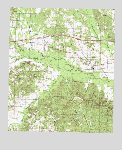
Hickory, MS USGS Topographic Map
Click on map above to begin viewing in our Map Viewer.

This topographic map contains these locations and features:
Feature Name Type Latitude Longitude GNIS ID View Map
Antioch Chistian ChurchChurchN32.2601°W89.0498°666310View Map
B J Blount Lake DamDamN32.3185°W89.0251°681198View Map
Berry School (historical)SchoolN32.3554°W89.0095°689446View Map
Bethel BranchStreamN32.3168°W89.0506°666877View Map
Bethel ChurchChurchN32.3304°W89.0478°666918View Map
Bethel Church (historical)ChurchN32.2529°W89.0070°689447View Map
Bogue Falema CreekStreamN32.3129°W89.0487°692663View Map
Chunky (historical)Populated PlaceN32.3710°W89.0987°710456View Map
Corinth ChurchChurchN32.3038°W89.1089°668836View Map
Fahrbach Lake DamDamN32.2668°W89.0451°681152View Map
Ferguson CemeteryCemeteryN32.3226°W89.0078°669947View Map
Hammond Store (historical)LocaleN32.3007°W89.0859°689487View Map
Hickman Chapel School (historical)SchoolN32.2857°W89.0409°689489View Map
HickoryPopulated PlaceN32.3176°W89.0256°671148View Map
Hickory Attendance Center (historical)SchoolN32.3182°W89.0251°710460View Map
Hickory CemeteryCemeteryN32.3263°W89.0223°671150View Map
Hickory Post OfficePost OfficeN32.3177°W89.0268°2768791View Map
Hickory Volunteer Fire DepartmentBuildingN32.3184°W89.0251°2667888View Map
Interchange 115CrossingN32.3449°W89.0442°691464View Map
LibertyPopulated PlaceN32.2751°W89.1209°710462View Map
Liberty ChurchChurchN32.2754°W89.1209°672448View Map
Mississippi State Experimental StationLocaleN32.3379°W89.0812°689505View Map
Mount Moriah ChurchChurchN32.2515°W89.0826°674063View Map
Mount Olive Church (historical)ChurchN32.3699°W89.0170°689507View Map
Newton Lookout TowerTowerN32.3710°W89.1206°711281View Map
Old Good Hope CemeteryCemeteryN32.2557°W89.0070°675190View Map
Old Norman CemeteryCemeteryN32.3383°W89.0890°675218View Map
Paula (historical)Populated PlaceN32.3160°W89.0556°710468View Map
Pleasant Ridge Baptist ChurchChurchN32.3693°W89.0106°676108View Map
Pleasant Ridge CemeteryCemeteryN32.3694°W89.0105°1805875View Map
Poplar SpringsPopulated PlaceN32.3001°W89.0873°689527View Map
Poplar Springs ChurchChurchN32.3054°W89.0959°676241View Map
R Doolittle Pond DamDamN32.3618°W89.1134°681256View Map
Rock Hill Church (historical)ChurchN32.2618°W89.0451°689533View Map
Rose FieldAirportN32.3457°W89.0380°2676401View Map
Saint Paul School (historical)SchoolN32.3551°W89.0709°689535View Map
Sand Springs ChurchChurchN32.3699°W89.0692°677353View Map
Shiloh ChurchChurchN32.3543°W89.1187°677685View Map
Simmons BranchStreamN32.2690°W89.1064°705483View Map
Spring Hill CemeteryCemeteryN32.2674°W89.0056°678096View Map
Supervisor District 5CivilN32.3051°W89.0195°712006View Map
Sweetwater School (historical)SchoolN32.2601°W89.0920°689544View Map
Tallow (historical)Populated PlaceN32.3001°W89.1167°710471View Map
Tarlow CreekStreamN32.3249°W89.1014°694943View Map
Town of HickoryCivilN32.3167°W89.0217°2405822View Map
Troy Brand Lake DamDamN32.3001°W89.0584°681180View Map
Turkey CreekStreamN32.3257°W89.0828°678952View Map
Urbo (historical)Populated PlaceN32.3196°W89.0862°689552View Map
W Parks Lake DamDamN32.3368°W89.1017°681229View Map
Walker BranchStreamN32.3449°W89.1009°679259View Map
Wall School (historical)SchoolN32.3385°W89.0831°689555View Map
Wickward (historical)Populated PlaceN32.2724°W89.0834°689560View Map
Wickware PondReservoirN32.2722°W89.0880°689561View Map

Note: Coordinates in the location and feature list above are referenced to NAD83 datum.


Copyright (C) 2008-2025 Ryan Niemi / Sunset Dynamics ... All Rights Reserved