TopoQuest Logo
Do you find TopoQuest useful?
Help keep TopoQuest running and adding new maps/features by donating!
Bitcoin:  19c7KJd3qBynnjoSw5npx9KScwjBe4ifkT
Litecoin:  LXs6TkuXGGXo1vDsWCkWVdjQX94eUKd6ui
Home View Maps Find Maps Find Places Resources & Links


Decatur NW, Mississippi Topographic Map

USGS Map Title: Decatur NW, MS
USGS Map MRC: 32089D2
DRG (GeoTIFF) Download: o32089d2.tif


Neighboring USGS Topographic Map Quads:


  Sebastopol, MS  
32089E3
 

  Union West, MS  
32089E2
 

  Union East, MS  
32089E1
 

  Conehatta, MS  
32089D3
 

  Decatur NW, MS  
32089D2
 

  Decatur, MS  
32089D1
 

  Lake, MS  
32089C3
 

  Newton, MS  
32089C2
 

  Hickory, MS  
32089C1


Map MRC Location:

N33°
W90°
N33°
W89°
H8 H7 H6 H5 H4 H3 H2 H1
G8 G7 G6 G5 G4 G3 G2 G1
F8 F7 F6 F5 F4 F3 F2 F1
E8 E7 E6 E5 E4 E3 E2 E1
D8 D7 D6 D5 D4 D3 D2 D1
C8 C7 C6 C5 C4 C3 C2 C1
B8 B7 B6 B5 B4 B3 B2 B1
A8 A7 A6 A5 A4 A3 A2 A1
N32°
W90°
N32°
W89°

Decatur NW, MS USGS 1:24K Topographic Map Preview:
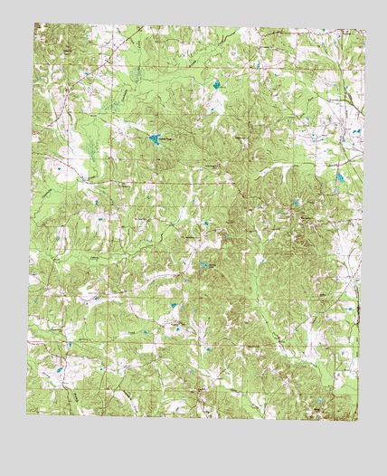
Decatur NW, MS USGS Topographic Map
Click on map above to begin viewing in our Map Viewer.

This topographic map contains these locations and features:
Feature Name Type Latitude Longitude GNIS ID View Map
Addy Store (historical)LocaleN32.4874°W89.2237°689440View Map
Barnes Mill (historical)LocaleN32.4690°W89.2006°689442View Map
Beat Line School (historical)SchoolN32.4426°W89.2162°689445View Map
Beatline ChurchChurchN32.4488°W89.2162°666680View Map
Bethlehem ChurchChurchN32.4646°W89.1692°666999View Map
Bill May Lake DamDamN32.4501°W89.1884°681380View Map
Brushy CreekStreamN32.4826°W89.2103°667692View Map
Buena Vista School (historical)SchoolN32.4426°W89.1526°689454View Map
Bufkin CemeteryCemeteryN32.4140°W89.2237°667762View Map
Center Point School (historical)SchoolN32.4771°W89.1556°689456View Map
Conehatta Volunteer Fire DepartmentBuildingN32.4559°W89.2382°2667771View Map
County PondReservoirN32.4637°W89.2033°668879View Map
County Pond DamDamN32.4635°W89.2001°681402View Map
Cross Roads ChurchChurchN32.4557°W89.1801°668969View Map
Doctor Moore Lake DamDamN32.3901°W89.1667°681285View Map
Fellowship ChurchChurchN32.4940°W89.1645°669937View Map
Gum Pond BranchStreamN32.4757°W89.1292°670797View Map
Hickory Grove School (historical)SchoolN32.4690°W89.1678°689490View Map
Hollingsworth CemeteryCemeteryN32.4326°W89.1859°671297View Map
Indian CemeteryCemeteryN32.4915°W89.1759°671676View Map
JeffPopulated PlaceN32.4213°W89.1278°691966View Map
Leach Store (historical)LocaleN32.4396°W89.2334°689497View Map
Macedonia ChurchChurchN32.4049°W89.1934°673004View Map
McMullan Lake DamDamN32.4468°W89.1334°681376View Map
McMullan Lake DamDamN32.4518°W89.1351°681383View Map
Midway ChurchChurchN32.3785°W89.1395°673547View Map
Okahta Talaia (historical)Populated PlaceN32.4626°W89.2473°710467View Map
Pilgrim Rest ChurchChurchN32.3985°W89.1678°675747View Map
Pine BluffPopulated PlaceN32.3821°W89.1851°689570View Map
Pine Bluff ChurchChurchN32.3835°W89.1856°675793View Map
Pine Ridge ChurchChurchN32.4382°W89.2062°675872View Map
Pleasant Valley ChurchChurchN32.4018°W89.2370°676139View Map
Poplar ChurchChurchN32.4910°W89.2384°676217View Map
Poplar Springs School (historical)SchoolN32.4910°W89.2398°689528View Map
Possum Trot Church (historical)ChurchN32.4571°W89.1956°689529View Map
Pumpkin CreekStreamN32.4929°W89.2098°676414View Map
Saint Mary ChurchChurchN32.4149°W89.1406°677142View Map
Scanlon (historical)Populated PlaceN32.4696°W89.1334°689537View Map
Spring LakeReservoirN32.4239°W89.1838°678151View Map
Spring Lake Hunting Club Lake DamDamN32.4235°W89.1851°681344View Map
StrattonPopulated PlaceN32.4996°W89.1342°678343View Map
Supervisor District 3CivilN32.4865°W89.2211°712004View Map
Toomer (historical)Populated PlaceN32.4113°W89.1259°710472View Map
Tuckers Mill (historical)LocaleN32.4846°W89.1712°689547View Map
Union Grove School (historical)SchoolN32.3763°W89.2462°689549View Map
Union Ridge School (historical)SchoolN32.4668°W89.2437°689550View Map
West Decatur ChurchChurchN32.4399°W89.1484°679480View Map

Note: Coordinates in the location and feature list above are referenced to NAD83 datum.


Copyright (C) 2008-2025 Ryan Niemi / Sunset Dynamics ... All Rights Reserved