TopoQuest Logo
Do you find TopoQuest useful?
Help keep TopoQuest running and adding new maps/features by donating!
Bitcoin:  19c7KJd3qBynnjoSw5npx9KScwjBe4ifkT
Litecoin:  LXs6TkuXGGXo1vDsWCkWVdjQX94eUKd6ui
Home View Maps Find Maps Find Places Resources & Links


Highland Springs, California Topographic Map

USGS Map Title: Highland Springs, CA
USGS Map MRC: 38122H8
DRG (GeoTIFF) Download: o38122h8.tif


Neighboring USGS Topographic Map Quads:


  Purdys Gardens, CA  
39123A1
 

  Lakeport, CA  
39122A8
 

  Lucerne, CA  
39122A7
 

  Hopland, CA  
38123H1
 

  Highland Springs, CA  
38122H8
 

  Kelseyville, CA  
38122H7
 

  Cloverdale, CA  
38123G1
 

  Asti, CA  
38122G8
 

  The Geysers, CA  
38122G7


Map MRC Location:

N39°
W123°
N39°
W122°
H8 H7 H6 H5 H4 H3 H2 H1
G8 G7 G6 G5 G4 G3 G2 G1
F8 F7 F6 F5 F4 F3 F2 F1
E8 E7 E6 E5 E4 E3 E2 E1
D8 D7 D6 D5 D4 D3 D2 D1
C8 C7 C6 C5 C4 C3 C2 C1
B8 B7 B6 B5 B4 B3 B2 B1
A8 A7 A6 A5 A4 A3 A2 A1
N38°
W123°
N38°
W122°

Highland Springs, CA USGS 1:24K Topographic Map Preview:
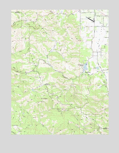
Highland Springs, CA USGS Topographic Map
Click on map above to begin viewing in our Map Viewer.

This topographic map contains these locations and features:
Feature Name Type Latitude Longitude GNIS ID View Map
Adobe Creek 1011 DamDamN38.9332°W122.8928°1664142View Map
Adobe ReservoirReservoirN38.9417°W122.8904°1657212View Map
Big Valley Community CenterLocaleN38.9868°W122.8942°257039View Map
Blood RanchLocaleN38.9616°W122.9444°1724023View Map
Chateau Du LacLocaleN38.9985°W122.9025°1766085View Map
Cloverdale PeakSummitN38.8832°W122.9939°221258View Map
Cow GladeFlatN38.9057°W122.9269°221700View Map
Davis RanchLocaleN38.8910°W122.9900°1724034View Map
Doe RockSummitN38.8918°W122.9700°222462View Map
Donovan ValleyStreamN38.9552°W122.9544°222512View Map
Gilliam RockSummitN38.9224°W122.9439°224173View Map
Graham 395 DamDamN38.9682°W122.9444°1663858View Map
High ValleyBasinN38.9227°W122.9672°225283View Map
High Valley RanchLocaleN38.9230°W122.9642°225285View Map
Highland CreekStreamN38.9518°W122.8942°225288View Map
Highland Creek 1011-002 DamDamN38.9482°W122.9028°1664143View Map
Highland SpringsPopulated PlaceN38.9371°W122.9069°1658749View Map
Highland Springs ReservoirReservoirN38.9428°W122.9059°1657213View Map
Hoil CreekStreamN38.8830°W122.9083°225435View Map
Kelseyville DivisionCivilN38.9832°W122.8861°2583196View Map
Lampson FieldAirportN38.9876°W122.8962°1653588View Map
Manning CreekStreamN38.9999°W122.9058°228024View Map
McGoldrick Ranch (historical)LocaleN38.9913°W122.9411°1724031View Map
Monument PeakSummitN38.9107°W122.9558°228993View Map
Red RockSummitN38.9080°W122.9639°231373View Map
Sheldon Ranch (historical)LocaleN38.9388°W122.9725°1724036View Map
Snyder RanchLocaleN38.9592°W122.8833°2677484View Map
Tyler CreekStreamN38.8871°W122.9647°236738View Map
Tyler ValleyValleyN38.8816°W122.9081°236743View Map

Note: Coordinates in the location and feature list above are referenced to NAD83 datum.


Copyright (C) 2008-2025 Ryan Niemi / Sunset Dynamics ... All Rights Reserved