TopoQuest Logo
Do you find TopoQuest useful?
Help keep TopoQuest running and adding new maps/features by donating!
Bitcoin:  19c7KJd3qBynnjoSw5npx9KScwjBe4ifkT
Litecoin:  LXs6TkuXGGXo1vDsWCkWVdjQX94eUKd6ui
Home View Maps Find Maps Find Places Resources & Links


Hillcrest, Virginia Topographic Map

USGS Map Title: Hillcrest, VA
USGS Map MRC: 37078D3
DRG (GeoTIFF) Download: o37078d3.tif


Neighboring USGS Topographic Map Quads:


  Dillwyn, VA  
37078E4
 

  Gold Hill, VA  
37078E3
 

  Whiteville, VA  
37078E2
 

  Willis Mountain, VA  
37078D4
 

  Hillcrest, VA  
37078D3
 

  Cumberland, VA  
37078D2
 

  Farmville, VA  
37078C4
 

  Rice, VA  
37078C3
 

  Deatonville, VA  
37078C2


Map MRC Location:

N38°
W79°
N38°
W78°
H8 H7 H6 H5 H4 H3 H2 H1
G8 G7 G6 G5 G4 G3 G2 G1
F8 F7 F6 F5 F4 F3 F2 F1
E8 E7 E6 E5 E4 E3 E2 E1
D8 D7 D6 D5 D4 D3 D2 D1
C8 C7 C6 C5 C4 C3 C2 C1
B8 B7 B6 B5 B4 B3 B2 B1
A8 A7 A6 A5 A4 A3 A2 A1
N37°
W79°
N37°
W78°

Hillcrest, VA USGS 1:24K Topographic Map Preview:
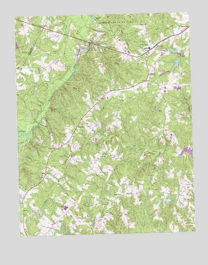
Hillcrest, VA USGS Topographic Map
Click on map above to begin viewing in our Map Viewer.

This topographic map contains these locations and features:
Feature Name Type Latitude Longitude GNIS ID View Map
Amos Dairy FarmLocaleN37.4097°W78.3158°2675259View Map
Antioch CemeteryCemeteryN37.4096°W78.3547°1494092View Map
Antioch ChurchChurchN37.4102°W78.3553°1462505View Map
Bish DamDamN37.4768°W78.2914°1489584View Map
Boston BranchStreamN37.4304°W78.3136°1463685View Map
Browns CemeteryCemeteryN37.3829°W78.3472°1494098View Map
Browns ChurchChurchN37.3827°W78.3475°1463921View Map
Browns StoreLocaleN37.4243°W78.3472°1463934View Map
Ca IraLocaleN37.4835°W78.3247°1464213View Map
Ca Ira DamDamN37.4807°W78.3228°1489552View Map
Ca Ira PondReservoirN37.4804°W78.3240°1464214View Map
Camp BranchStreamN37.4604°W78.3458°1464312View Map
Centenary CemeteryCemeteryN37.4015°W78.2511°1494105View Map
Centenary ChurchChurchN37.4015°W78.2511°1464667View Map
Clements DamDamN37.4735°W78.2597°1489543View Map
Clements LakeReservoirN37.4706°W78.2605°1489544View Map
Collins DamDamN37.4785°W78.2597°1502235View Map
Collins DamDamN37.4752°W78.2581°1502239View Map
Collins LakeReservoirN37.4780°W78.2616°1489540View Map
Corner Stone ChurchChurchN37.4199°W78.3122°1465262View Map
Cotton TownPopulated PlaceN37.3968°W78.3019°1477227View Map
Cumberland Census Designated PlaceCensusN37.4915°W78.2576°2629019View Map
Cumberland County Middle SchoolSchoolN37.4800°W78.2790°1494112View Map
Cumberland Volunteer Rescue SquadBuildingN37.4877°W78.2619°2331913View Map
Cumberland Volunteer Rescue SquadBuildingN37.4878°W78.2564°2075465View Map
District 4CivilN37.4122°W78.3258°1927240View Map
Gnegy DamDamN37.4652°W78.2697°1489583View Map
Grace ChurchChurchN37.4838°W78.3292°1467312View Map
Guinea CemeteryCemeteryN37.3954°W78.2608°1494123View Map
Guinea ChurchChurchN37.3960°W78.2603°1467590View Map
Guinea MillsPopulated PlaceN37.4371°W78.3317°1495631View Map
HawkPopulated PlaceN37.4099°W78.3561°1495666View Map
HillcrestPopulated PlaceN37.4827°W78.2742°1495694View Map
Holmans Mill (historical)LocaleN37.4274°W78.3183°1494133View Map
Horsepen CreekStreamN37.4207°W78.2750°1468291View Map
House of PrayerChurchN37.4649°W78.2800°1468328View Map
Ivy BranchStreamN37.4965°W78.3372°1468549View Map
John Randolph High School (historical)SchoolN37.3832°W78.3469°1502769View Map
Jones DamDamN37.4552°W78.2581°1489581View Map
Landis DamDamN37.3918°W78.2681°1489582View Map
Little Guinea CreekStreamN37.4304°W78.3136°1469556View Map
Little Willis RiverStreamN37.4324°W78.3694°1469688View Map
McRaePopulated PlaceN37.4613°W78.2825°1477528View Map
Midway ChurchChurchN37.3979°W78.2944°1470437View Map
Morton School (historical)SchoolN37.3974°W78.3017°1494141View Map
Oak Hill LakeReservoirN37.4984°W78.3175°1471756View Map
Payne CreekStreamN37.4979°W78.3264°1472129View Map
Rock CreekStreamN37.4860°W78.3219°1473361View Map
Swans LakeReservoirN37.4213°W78.2517°1489557View Map
T Edward Stimpson DamDamN37.3902°W78.3414°1489566View Map
T Edward Stimpson PondReservoirN37.3907°W78.3418°1489567View Map
Tear Wallet ChurchChurchN37.4779°W78.2681°1475527View Map
Tearwallet Baptist ChurchChurchN37.4804°W78.2750°1494166View Map
Wilcks DamDamN37.3752°W78.3381°1489558View Map
Willis River Number Nine DamDamN37.4768°W78.3731°1489278View Map

Note: Coordinates in the location and feature list above are referenced to NAD83 datum.


Copyright (C) 2008-2025 Ryan Niemi / Sunset Dynamics ... All Rights Reserved