TopoQuest Logo
Do you find TopoQuest useful?
Help keep TopoQuest running and adding new maps/features by donating!
Bitcoin:  19c7KJd3qBynnjoSw5npx9KScwjBe4ifkT
Litecoin:  LXs6TkuXGGXo1vDsWCkWVdjQX94eUKd6ui
Home View Maps Find Maps Find Places Resources & Links


Cumberland, Virginia Topographic Map

USGS Map Title: Cumberland, VA
USGS Map MRC: 37078D2
DRG (GeoTIFF) Download: o37078d2.tif


Neighboring USGS Topographic Map Quads:


  Gold Hill, VA  
37078E3
 

  Whiteville, VA  
37078E2
 

  Trenholm, VA  
37078E1
 

  Hillcrest, VA  
37078D3
 

  Cumberland, VA  
37078D2
 

  Ballsville, VA  
37078D1
 

  Rice, VA  
37078C3
 

  Deatonville, VA  
37078C2
 

  Jetersville, VA  
37078C1


Map MRC Location:

N38°
W79°
N38°
W78°
H8 H7 H6 H5 H4 H3 H2 H1
G8 G7 G6 G5 G4 G3 G2 G1
F8 F7 F6 F5 F4 F3 F2 F1
E8 E7 E6 E5 E4 E3 E2 E1
D8 D7 D6 D5 D4 D3 D2 D1
C8 C7 C6 C5 C4 C3 C2 C1
B8 B7 B6 B5 B4 B3 B2 B1
A8 A7 A6 A5 A4 A3 A2 A1
N37°
W79°
N37°
W78°

Cumberland, VA USGS 1:24K Topographic Map Preview:
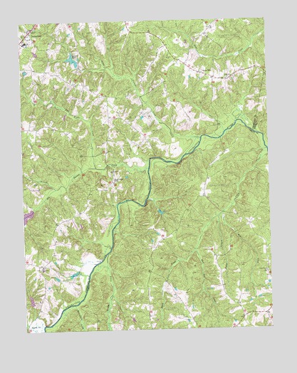
Cumberland, VA USGS Topographic Map
Click on map above to begin viewing in our Map Viewer.

This topographic map contains these locations and features:
Feature Name Type Latitude Longitude GNIS ID View Map
Amelia County Fire Services CoordinatorBuildingN37.4127°W78.1765°2331897View Map
AngolaPopulated PlaceN37.4015°W78.2400°1477074View Map
Angola CreekStreamN37.3763°W78.2411°1462483View Map
Big Guinea CreekStreamN37.4407°W78.1856°1463354View Map
Bull Run CreekStreamN37.4071°W78.1633°1464075View Map
Cedar Fork School (historical)SchoolN37.4621°W78.2050°1494104View Map
Center ChurchChurchN37.4940°W78.2492°1464671View Map
Center Union ChurchChurchN37.4768°W78.1450°1464676View Map
Chesapeake Corporation DamDamN37.4235°W78.1814°1489130View Map
Chester Grove ChurchChurchN37.3982°W78.1269°1464800View Map
CumberlandPopulated PlaceN37.4960°W78.2453°1498472View Map
Cumberland County CourthouseBuildingN37.4974°W78.2439°1494110View Map
Cumberland County Elementary SchoolSchoolN37.4863°W78.2493°1468604View Map
Cumberland County High SchoolSchoolN37.4866°W78.2492°1494111View Map
Cumberland County Sheriff's OfficeBuildingN37.4973°W78.2440°2332086View Map
Cumberland County Sheriff's OfficeBuildingN37.4977°W78.2439°2075461View Map
Cumberland Post OfficePost OfficeN37.4964°W78.2442°1494113View Map
Dawsons CreekStreamN37.3854°W78.2247°1465665View Map
District 3CivilN37.4727°W78.2344°1927220View Map
Doctor W B Blanton DamDamN37.3852°W78.2464°1489564View Map
Doctor W B Blanton PondReservoirN37.3877°W78.2466°1489565View Map
Doe BranchStreamN37.4329°W78.2333°1465856View Map
Felixville (historical)Populated PlaceN37.4571°W78.1678°1494114View Map
Fitzgerald ChurchChurchN37.4946°W78.2453°1466624View Map
Garrett DamDamN37.4821°W78.2214°1489545View Map
Garrett LakeReservoirN37.4835°W78.2181°1489546View Map
Garrett PondReservoirN37.4848°W78.2231°1467007View Map
Grove CemeteryCemeteryN37.4863°W78.1747°1494122View Map
Grove ChurchChurchN37.4852°W78.1753°1467571View Map
Jamerson DamDamN37.4885°W78.1814°1489571View Map
Little Guinea CreekStreamN37.4532°W78.1589°1469557View Map
Mill CreekStreamN37.4224°W78.1483°1470485View Map
Payne ChurchChurchN37.4965°W78.2453°1472127View Map
Rerock ChurchChurchN37.3754°W78.1864°1497807View Map
Rocky BranchStreamN37.4207°W78.1508°1473430View Map
Rocky Mount ChurchChurchN37.4393°W78.2050°1473469View Map
Rogers DamDamN37.4785°W78.2481°1489569View Map
Sandy CreekStreamN37.4063°W78.2072°1474017View Map
Stony Point MillsLocaleN37.4354°W78.2042°1475217View Map
Sunny SidePopulated PlaceN37.4793°W78.1592°1477792View Map
Swans DamDamN37.4218°W78.2481°1489556View Map
Tear Wallet CreekStreamN37.4413°W78.2125°1475528View Map
Tom Rogers Farm PondReservoirN37.4785°W78.2481°1489570View Map

Note: Coordinates in the location and feature list above are referenced to NAD83 datum.


Copyright (C) 2008-2024 Ryan Niemi / Sunset Dynamics ... All Rights Reserved