TopoQuest Logo
Do you find TopoQuest useful?
Help keep TopoQuest running and adding new maps/features by donating!
Bitcoin:  19c7KJd3qBynnjoSw5npx9KScwjBe4ifkT
Litecoin:  LXs6TkuXGGXo1vDsWCkWVdjQX94eUKd6ui
Home View Maps Find Maps Find Places Resources & Links


Gold Hill, Virginia Topographic Map

USGS Map Title: Gold Hill, VA
USGS Map MRC: 37078E3
DRG (GeoTIFF) Download: o37078e3.tif


Neighboring USGS Topographic Map Quads:


  Diana Mills, VA  
37078F4
 

  Arvonia, VA  
37078F3
 

  Lakeside Village, VA  
37078F2
 

  Dillwyn, VA  
37078E4
 

  Gold Hill, VA  
37078E3
 

  Whiteville, VA  
37078E2
 

  Willis Mountain, VA  
37078D4
 

  Hillcrest, VA  
37078D3
 

  Cumberland, VA  
37078D2


Map MRC Location:

N38°
W79°
N38°
W78°
H8 H7 H6 H5 H4 H3 H2 H1
G8 G7 G6 G5 G4 G3 G2 G1
F8 F7 F6 F5 F4 F3 F2 F1
E8 E7 E6 E5 E4 E3 E2 E1
D8 D7 D6 D5 D4 D3 D2 D1
C8 C7 C6 C5 C4 C3 C2 C1
B8 B7 B6 B5 B4 B3 B2 B1
A8 A7 A6 A5 A4 A3 A2 A1
N37°
W79°
N37°
W78°

Gold Hill, VA USGS 1:24K Topographic Map Preview:
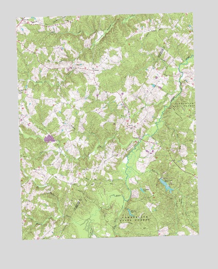
Gold Hill, VA USGS Topographic Map
Click on map above to begin viewing in our Map Viewer.

This topographic map contains these locations and features:
Feature Name Type Latitude Longitude GNIS ID View Map
Arrowhead LakeReservoirN37.5262°W78.2894°1501944View Map
Arrowhead Lake DamDamN37.5271°W78.2903°1489577View Map
Bear CreekStreamN37.5396°W78.2986°1462884View Map
Bear Creek DamDamN37.5335°W78.2747°1489538View Map
Bear Creek LakeReservoirN37.5285°W78.2725°1462885View Map
Bear Creek Lake State ParkParkN37.5274°W78.2706°1462886View Map
Bear Creek State ParkParkN37.5293°W78.2708°1494094View Map
Benelli DamDamN37.5851°W78.2781°1489578View Map
Bob BranchStreamN37.5999°W78.3347°1463622View Map
Bonbrook CreekStreamN37.6007°W78.2506°1463653View Map
Bright Morning Star Church (historical)ChurchN37.5732°W78.3375°1501499View Map
Brown ChapelChurchN37.5835°W78.3742°1463905View Map
Buck and Game CreekStreamN37.5821°W78.2597°1463974View Map
Buckingham Female Collegiate Institute Historic DistrictParkN37.5826°W78.3719°1501505View Map
Buffalo CreekStreamN37.5107°W78.3281°1464039View Map
Cat BranchStreamN37.5940°W78.2611°1464532View Map
Cedar ChurchChurchN37.5465°W78.3733°1464588View Map
Cornerstone CemeteryCemeteryN37.5468°W78.3750°1501515View Map
Cornerstone ChurchChurchN37.5465°W78.3747°1465264View Map
Cumberland State ForestForestN37.5082°W78.2961°1465521View Map
District 7CivilN37.5832°W78.3740°2390689View Map
District 7, Gold Hill (historical)CivilN37.6076°W78.3675°1927330View Map
Gold HillPopulated PlaceN37.6235°W78.3703°1467186View Map
Gravel HillLocaleN37.5829°W78.3719°1467380View Map
Gravel HillPopulated PlaceN37.5840°W78.3747°1493018View Map
Halfway CreekStreamN37.5521°W78.3183°1467660View Map
HatcherPopulated PlaceN37.5618°W78.2992°1477399View Map
Hatcher Baptist ChurchChurchN37.5615°W78.3003°1494127View Map
Hatcher CreekStreamN37.5529°W78.2903°1467821View Map
Hatcher Methodist Church (historical)ChurchN37.5615°W78.3003°1494128View Map
Horn Quater CreekStreamN37.5651°W78.2756°1468245View Map
Jones ChapelChurchN37.5615°W78.2947°1468829View Map
Jones School (historical)SchoolN37.5699°W78.3186°1501549View Map
LawfordPopulated PlaceN37.6165°W78.2769°1477479View Map
Little Bear CreekStreamN37.5263°W78.2669°1469464View Map
Little Buffalo CreekStreamN37.5126°W78.3453°1469488View Map
Little CreekStreamN37.6135°W78.3142°1469511View Map
Mount Olive ChurchChurchN37.5529°W78.2517°1470971View Map
New Dominion SchoolSchoolN37.5275°W78.3721°2499258View Map
New Hope ChurchChurchN37.6221°W78.3375°1471442View Map
NuckolsPopulated PlaceN37.5940°W78.3214°1495077View Map
Oak Hill LakeReservoirN37.6235°W78.3181°1489580View Map
Oak Hill Lake DamDamN37.6235°W78.3181°1489579View Map
Petersville ChurchChurchN37.6163°W78.2744°1472236View Map
Petersville School (historical)SchoolN37.6163°W78.2739°1501583View Map
Rock Point CreekStreamN37.5210°W78.3025°1473384View Map
Trents MillPopulated PlaceN37.5549°W78.2894°1475850View Map
Trents Mill School (historical)SchoolN37.5463°W78.3033°1494169View Map
Union HillPopulated PlaceN37.5379°W78.3292°1495156View Map
White Oak BranchStreamN37.5340°W78.2997°1476596View Map
Willis River Number Seven DamDamN37.5551°W78.3514°1489277View Map
Winston LakeReservoirN37.5138°W78.2983°1502163View Map
Winston Lake DamDamN37.5151°W78.2997°1489576View Map
Zion ChurchChurchN37.5307°W78.3381°1474393View Map

Note: Coordinates in the location and feature list above are referenced to NAD83 datum.


Copyright (C) 2008-2025 Ryan Niemi / Sunset Dynamics ... All Rights Reserved