TopoQuest Logo
Do you find TopoQuest useful?
Help keep TopoQuest running and adding new maps/features by donating!
Bitcoin:  19c7KJd3qBynnjoSw5npx9KScwjBe4ifkT
Litecoin:  LXs6TkuXGGXo1vDsWCkWVdjQX94eUKd6ui
Home View Maps Find Maps Find Places Resources & Links


Hiwasse, Arkansas Topographic Map

USGS Map Title: Hiwasse, AR
USGS Map MRC: 36094D3
DRG (GeoTIFF) Download: o36094d3.tif


Neighboring USGS Topographic Map Quads:


  Noel, MO  
36094E4
 

  Jane, MO  
36094E3
 

  Powell, MO  
36094E2
 

  Gravette, AR  
36094D4
 

  Hiwasse, AR  
36094D3
 

  Bentonville North, AR  
36094D2
 

  Gentry, AR  
36094C4
 

  Centerton, AR  
36094C3
 

  Bentonville South, AR  
36094C2


Map MRC Location:

N37°
W95°
N37°
W94°
H8 H7 H6 H5 H4 H3 H2 H1
G8 G7 G6 G5 G4 G3 G2 G1
F8 F7 F6 F5 F4 F3 F2 F1
E8 E7 E6 E5 E4 E3 E2 E1
D8 D7 D6 D5 D4 D3 D2 D1
C8 C7 C6 C5 C4 C3 C2 C1
B8 B7 B6 B5 B4 B3 B2 B1
A8 A7 A6 A5 A4 A3 A2 A1
N36°
W95°
N36°
W94°

Hiwasse, AR USGS 1:24K Topographic Map Preview:
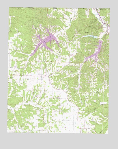
Hiwasse, AR USGS Topographic Map
Click on map above to begin viewing in our Map Viewer.

This topographic map contains these locations and features:
Feature Name Type Latitude Longitude GNIS ID View Map
Ashmore FieldAirportN36.3835°W94.2940°2650743View Map
Banks School (historical)SchoolN36.4323°W94.3602°75369View Map
Bella VistaPopulated PlaceN36.4815°W94.2733°46360View Map
Bella Vista Country ClubLocaleN36.4795°W94.2574°81968View Map
Bella Vista Fire Department Station 3BuildingN36.4897°W94.3415°2116128View Map
Benton County Sheriff's Office Bella Vista DivisionBuildingN36.4573°W94.2792°2119019View Map
Bertschy FarmsLocaleN36.4308°W94.3436°2709209View Map
Blackjack ChurchChurchN36.4645°W94.3733°46685View Map
Boling FarmsLocaleN36.4264°W94.3631°2709210View Map
Calis (historical)Populated PlaceN36.3773°W94.3249°75414View Map
CavernaPopulated PlaceN36.4996°W94.2693°47555View Map
Centerton Gamble Elementary SchoolSchoolN36.3813°W94.2920°2121455View Map
Cross Lanes School (historical)SchoolN36.3879°W94.2930°75454View Map
D and J FarmsLocaleN36.4406°W94.3656°2709213View Map
Daniels CemeteryCemeteryN36.4465°W94.3705°48349View Map
Donivan School (historical)SchoolN36.4645°W94.3683°75472View Map
Gobblers KnobSummitN36.4590°W94.3527°57828View Map
HiwassePopulated PlaceN36.4317°W94.3338°77191View Map
Hiwasse Census Designated PlaceCensusN36.4290°W94.3309°2582916View Map
Hiwasse Post OfficePost OfficeN36.4320°W94.3360°84562View Map
Hiwasse School (historical)SchoolN36.4309°W94.3310°75556View Map
Hiwassee Fire StationBuildingN36.4310°W94.3315°2116581View Map
Keith CemeteryCemeteryN36.4095°W94.3341°77394View Map
Lake AvalonReservoirN36.4734°W94.2619°79715View Map
Lake Avalon DamDamN36.4734°W94.2619°79714View Map
Lake WindsorReservoirN36.4701°W94.2585°79713View Map
Lake Windsor DamDamN36.4701°W94.2585°79712View Map
Lynn Church of ChristChurchN36.4323°W94.3602°77566View Map
MillerPopulated PlaceN36.4165°W94.2644°75916View Map
Miller CemeteryCemeteryN36.4162°W94.2635°75917View Map
Miller ChurchChurchN36.4162°W94.2641°52060View Map
Miller School (historical)SchoolN36.4162°W94.2641°75918View Map
Mount Olive ChurchChurchN36.3806°W94.3702°52365View Map
Mount Pleasant CemeteryCemeteryN36.4298°W94.3733°75923View Map
Mount Pleasant Missionary Baptist ChurchChurchN36.4295°W94.3727°77739View Map
Pleasant Hill School (historical)SchoolN36.4167°W94.2641°75969View Map
Race (historical)Populated PlaceN36.3912°W94.2883°75984View Map
Rocky Comfort (historical)Populated PlaceN36.4659°W94.3013°75994View Map
Rocky Comfort Church (historical)ChurchN36.4662°W94.3010°75995View Map
Rocky Comfort School (historical)SchoolN36.4662°W94.3010°75996View Map
Tanyard CreekStreamN36.4784°W94.2524°55428View Map
Town of Bella VistaCivilN36.4667°W94.2708°2405233View Map
Township 10CivilN36.4539°W94.3064°1989195View Map
Township of Dickson (historical)CivilN36.4487°W94.3294°69579View Map
Township of Garland (historical)CivilN36.3754°W94.3252°69585View Map
Zion Rest Baptist ChurchChurchN36.3795°W94.2783°78837View Map

Note: Coordinates in the location and feature list above are referenced to NAD83 datum.


Copyright (C) 2008-2024 Ryan Niemi / Sunset Dynamics ... All Rights Reserved