TopoQuest Logo
Do you find TopoQuest useful?
Help keep TopoQuest running and adding new maps/features by donating!
Bitcoin:  19c7KJd3qBynnjoSw5npx9KScwjBe4ifkT
Litecoin:  LXs6TkuXGGXo1vDsWCkWVdjQX94eUKd6ui
Home View Maps Find Maps Find Places Resources & Links


Centerton, Arkansas Topographic Map

USGS Map Title: Centerton, AR
USGS Map MRC: 36094C3
DRG (GeoTIFF) Download: o36094c3.tif


Neighboring USGS Topographic Map Quads:


  Gravette, AR  
36094D4
 

  Hiwasse, AR  
36094D3
 

  Bentonville North, AR  
36094D2
 

  Gentry, AR  
36094C4
 

  Centerton, AR  
36094C3
 

  Bentonville South, AR  
36094C2
 

  Gallatin, AR  
36094B4
 

  Robinson, AR  
36094B3
 

  Springdale, AR  
36094B2


Map MRC Location:

N37°
W95°
N37°
W94°
H8 H7 H6 H5 H4 H3 H2 H1
G8 G7 G6 G5 G4 G3 G2 G1
F8 F7 F6 F5 F4 F3 F2 F1
E8 E7 E6 E5 E4 E3 E2 E1
D8 D7 D6 D5 D4 D3 D2 D1
C8 C7 C6 C5 C4 C3 C2 C1
B8 B7 B6 B5 B4 B3 B2 B1
A8 A7 A6 A5 A4 A3 A2 A1
N36°
W95°
N36°
W94°

Centerton, AR USGS 1:24K Topographic Map Preview:
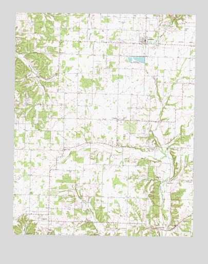
Centerton, AR USGS Topographic Map
Click on map above to begin viewing in our Map Viewer.

This topographic map contains these locations and features:
Feature Name Type Latitude Longitude GNIS ID View Map
Anderson SpringSpringN36.3004°W94.3002°75363View Map
Ardis Ann Middle SchoolSchoolN36.3716°W94.2505°2039003View Map
Armstrong CemeteryCemeteryN36.2865°W94.3349°45928View Map
Barron CemeteryCemeteryN36.3220°W94.2908°76241View Map
Benton CountyCivilN36.3387°W94.2562°69896View Map
Bergin School (historical)SchoolN36.3390°W94.3613°75387View Map
Bethlehem Baptist ChurchChurchN36.3529°W94.3452°76327View Map
Bluff SpringSpringN36.2834°W94.2760°75399View Map
Castleville (historical)Populated PlaceN36.2576°W94.3055°75419View Map
CentertonPopulated PlaceN36.3598°W94.2852°76573View Map
Centerton CemeteryCemeteryN36.3626°W94.2852°75425View Map
Centerton Fire StationBuildingN36.3606°W94.2845°2116251View Map
Centerton Hatchery Upper Pond DamDamN36.3501°W94.2952°80922View Map
Centerton Police DepartmentBuildingN36.3563°W94.2933°2119012View Map
Centerton Post OfficePost OfficeN36.3583°W94.2994°84534View Map
Centerton State Fish HatcheryLocaleN36.3495°W94.2883°81999View Map
Christian Church (historical)ChurchN36.2870°W94.3494°75436View Map
City of CentertonCivilN36.3552°W94.2959°2404021View Map
Coffelt CemeteryCemeteryN36.3237°W94.3416°47889View Map
Council Grove Methodist ChurchChurchN36.2815°W94.2683°75452View Map
Douglas CemeteryCemeteryN36.2640°W94.3233°48584View Map
Douglas School (historical)SchoolN36.2581°W94.3447°75474View Map
Eagle CornerPopulated PlaceN36.3017°W94.3677°75482View Map
Eagle Corner School (historical)SchoolN36.3017°W94.3680°75483View Map
Evening Star School (historical)SchoolN36.2929°W94.2547°75490View Map
Gamble CemeteryCemeteryN36.3701°W94.3024°49317View Map
Healing SpringsPopulated PlaceN36.2548°W94.2783°49976View Map
Healing SpringsSpringN36.2548°W94.2810°75543View Map
Healing Springs BridgeBridgeN36.2540°W94.2710°75544View Map
HighfillPopulated PlaceN36.2615°W94.3577°57923View Map
Highfill Baptist ChurchChurchN36.2595°W94.3572°75551View Map
Highfill CemeteryCemeteryN36.2540°W94.3488°50103View Map
Highfill Fire DepartmentBuildingN36.2586°W94.3500°2116565View Map
Highfill Methodist ChurchChurchN36.2612°W94.3549°75552View Map
Highfill SpringSpringN36.2509°W94.3483°75553View Map
Hoover (historical)Populated PlaceN36.2506°W94.3419°75558View Map
Jackson CemeteryCemeteryN36.3665°W94.2577°50559View Map
Mason ValleyPopulated PlaceN36.2992°W94.3408°58132View Map
Mason Valley Baptist ChurchChurchN36.2979°W94.3416°75905View Map
Mason Valley Methodist Church (historical)ChurchN36.2940°W94.3441°75907View Map
Mason Valley School (historical)SchoolN36.2940°W94.3441°75908View Map
McKissick SpringSpringN36.3600°W94.2858°75912View Map
Northwest Arkansas Regional AirportAirportN36.2760°W94.2973°2650800View Map
Northwest Arkansas Regional Airport Fire DepartmentBuildingN36.2797°W94.3026°2116132View Map
Northwest Arkansas Regional Airport Police DepartmentBuildingN36.2756°W94.2972°2119007View Map
Osage MillsPopulated PlaceN36.2812°W94.2688°77927View Map
Osage Mills DamDamN36.2945°W94.2676°75945View Map
Osage Valley School (historical)SchoolN36.2701°W94.2655°75947View Map
Parn (historical)Populated PlaceN36.3398°W94.3452°75954View Map
Parn CemeteryCemeteryN36.3401°W94.3460°77957View Map
Phillips CemeteryCemeteryN36.2814°W94.2508°53337View Map
Pruitt FarmLocaleN36.3689°W94.3728°2709217View Map
SebaPopulated PlaceN36.3729°W94.2938°57182View Map
Spring BranchStreamN36.2951°W94.2688°76032View Map
Sunshine SchoolSchoolN36.3159°W94.3002°55354View Map
Temperance Hill CemeteryCemeteryN36.3001°W94.2774°55484View Map
Temperence Hill Baptist Church (historical)ChurchN36.3017°W94.2767°76055View Map
Town of HighfillCivilN36.2765°W94.3235°2405830View Map
Township 9CivilN36.3536°W94.2680°1989193View Map
Township of Anderson (historical)CivilN36.2917°W94.2835°69571View Map
Township of Hoover (historical)CivilN36.2506°W94.3419°69588View Map
Township of Mason Valley (historical)CivilN36.3084°W94.3502°69590View Map
Upper PondReservoirN36.3501°W94.2952°80923View Map
VaughnPopulated PlaceN36.3154°W94.3041°58798View Map
Vaughn Presbyterian ChurchChurchN36.3145°W94.3033°76071View Map
Vaughn School (historical)SchoolN36.3151°W94.3033°76072View Map
Webb FarmLocaleN36.3572°W94.3414°2709221View Map

Note: Coordinates in the location and feature list above are referenced to NAD83 datum.


Copyright (C) 2008-2025 Ryan Niemi / Sunset Dynamics ... All Rights Reserved