TopoQuest Logo
Do you find TopoQuest useful?
Help keep TopoQuest running and adding new maps/features by donating!
Bitcoin:  19c7KJd3qBynnjoSw5npx9KScwjBe4ifkT
Litecoin:  LXs6TkuXGGXo1vDsWCkWVdjQX94eUKd6ui
Home View Maps Find Maps Find Places Resources & Links


Gravette, Arkansas Topographic Map

USGS Map Title: Gravette, AR
USGS Map MRC: 36094D4
DRG (GeoTIFF) Download: o36094d4.tif


Neighboring USGS Topographic Map Quads:


  South West City, MO  
36094E5
 

  Noel, MO  
36094E4
 

  Jane, MO  
36094E3
 

  Colcord NE, AR  
36094D5
 

  Gravette, AR  
36094D4
 

  Hiwasse, AR  
36094D3
 

  Cherokee City, AR  
36094C5
 

  Gentry, AR  
36094C4
 

  Centerton, AR  
36094C3


Map MRC Location:

N37°
W95°
N37°
W94°
H8 H7 H6 H5 H4 H3 H2 H1
G8 G7 G6 G5 G4 G3 G2 G1
F8 F7 F6 F5 F4 F3 F2 F1
E8 E7 E6 E5 E4 E3 E2 E1
D8 D7 D6 D5 D4 D3 D2 D1
C8 C7 C6 C5 C4 C3 C2 C1
B8 B7 B6 B5 B4 B3 B2 B1
A8 A7 A6 A5 A4 A3 A2 A1
N36°
W95°
N36°
W94°

Gravette, AR USGS 1:24K Topographic Map Preview:
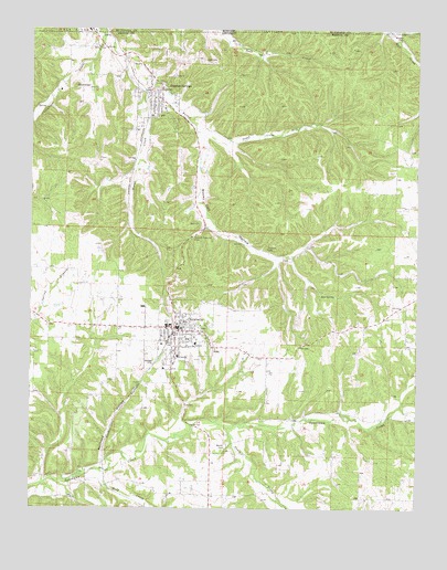
Gravette, AR USGS Topographic Map
Click on map above to begin viewing in our Map Viewer.

This topographic map contains these locations and features:
Feature Name Type Latitude Longitude GNIS ID View Map
Bear SpringSpringN36.4307°W94.4063°46241View Map
Beavers CemeteryCemeteryN36.4984°W94.3802°46280View Map
Bella Vista FieldAirportN36.4166°W94.4381°2650788View Map
Bethel CemeteryCemeteryN36.3917°W94.4366°46434View Map
Bethel Church (historical)ChurchN36.3920°W94.4355°75388View Map
Brown Military Academy of the Ozarks (historical)SchoolN36.4795°W94.4574°75407View Map
Butler Creek Baptist ChurchChurchN36.4956°W94.4791°76475View Map
Butler Creek BridgeBridgeN36.4842°W94.4583°75408View Map
Butler Creek CemeteryCemeteryN36.4959°W94.4802°75409View Map
Butler Creek School (historical)SchoolN36.4951°W94.4769°75410View Map
Circle L RanchLocaleN36.4389°W94.4986°2709212View Map
City of GravetteCivilN36.4281°W94.3810°2403729View Map
City of Sulphur SpringsCivilN36.4835°W94.4591°2405541View Map
Cottage Grove School (historical)SchoolN36.3784°W94.4563°75449View Map
Dorsey (historical)Populated PlaceN36.3812°W94.4752°75473View Map
Eagle Rock FarmsLocaleN36.4264°W94.4358°2709214View Map
Eldred FarmsLocaleN36.3850°W94.4358°2709215View Map
Field Kindley Memorial ParkParkN36.4220°W94.4438°75502View Map
Gallatin (historical)Populated PlaceN36.3790°W94.4266°75524View Map
GLENN DUFFY ELEMENTARY SCHOOLSchoolN36.4165°W94.4467°2039007View Map
Grand Army of the Republic CemeteryCemeteryN36.4915°W94.4433°49296View Map
GravettePopulated PlaceN36.4220°W94.4535°77061View Map
Gravette Fire DepartmentBuildingN36.4251°W94.4535°2116500View Map
Gravette Fire Department AmbulanceBuildingN36.4251°W94.4535°2119203View Map
Gravette High SchoolSchoolN36.4210°W94.4348°75536View Map
GRAVETTE MIDDLE SCHOOLSchoolN36.4181°W94.4460°2039008View Map
Gravette Police DepartmentBuildingN36.4220°W94.4514°2119015View Map
Gravette Upper Elementary SchoolSchoolN36.4175°W94.4443°2039009View Map
Hillcrest CemeteryCemeteryN36.4292°W94.4558°75555View Map
Holts Mill (historical)LocaleN36.3967°W94.4333°75557View Map
Horse CreekStreamN36.4840°W94.4638°50326View Map
NeboPopulated PlaceN36.4167°W94.4410°77796View Map
Ozarks Community Hospital of GravetteHospitalN36.4086°W94.4605°75537View Map
Pattons Mill (historical)LocaleN36.3998°W94.3991°75955View Map
Pond (historical)Populated PlaceN36.3779°W94.3905°75976View Map
R B FarmsLocaleN36.3775°W94.4914°2709218View Map
Railroad HollowValleyN36.3876°W94.4763°53878View Map
Rattlesnake HollowValleyN36.4998°W94.3827°725120View Map
Rocky Dell HollowValleyN36.4720°W94.4458°54136View Map
Rocky Dell School (historical)SchoolN36.4384°W94.4197°75998View Map
Round Top (historical)Populated PlaceN36.4845°W94.4841°76007View Map
RoundtopSummitN36.4854°W94.4863°78223View Map
Seilers BranchStreamN36.4734°W94.4466°76014View Map
South Prong Spavinaw CreekStreamN36.3959°W94.4360°78414View Map
Spavinaw Creek BridgeBridgeN36.3840°W94.4816°76031View Map
Sulphur SpringsPopulated PlaceN36.4834°W94.4585°58710View Map
Sulphur SpringsSpringN36.4845°W94.4579°76046View Map
Sulphur Springs City ParkParkN36.4842°W94.4580°76047View Map
Sulphur Springs Fire StationBuildingN36.4825°W94.4594°2117189View Map
Sulphur Springs High SchoolSchoolN36.4759°W94.4616°76048View Map
Sulphur Springs Police DepartmentBuildingN36.4775°W94.4613°2119020View Map
Sulphur Springs Post OfficePost OfficeN36.4806°W94.4581°84641View Map
Sycamore School (historical)SchoolN36.4106°W94.4133°76052View Map
Township 11CivilN36.3913°W94.4714°1989196View Map
Township of Sulphur Springs (historical)CivilN36.4695°W94.4544°69597View Map
Township of Wallace (historical)CivilN36.4167°W94.4460°69599View Map
Whitman FarmLocaleN36.3775°W94.4558°2709222View Map
Wolf CreekStreamN36.3842°W94.4760°78799View Map

Note: Coordinates in the location and feature list above are referenced to NAD83 datum.


Copyright (C) 2008-2024 Ryan Niemi / Sunset Dynamics ... All Rights Reserved