TopoQuest Logo
Do you find TopoQuest useful?
Help keep TopoQuest running and adding new maps/features by donating!
Bitcoin:  19c7KJd3qBynnjoSw5npx9KScwjBe4ifkT
Litecoin:  LXs6TkuXGGXo1vDsWCkWVdjQX94eUKd6ui
Home View Maps Find Maps Find Places Resources & Links


Hodgenville, Kentucky Topographic Map

USGS Map Title: Hodgenville, KY
USGS Map MRC: 37085E6
DRG (GeoTIFF) Download: o37085e6.tif


Neighboring USGS Topographic Map Quads:


  Elizabethtown, KY  
37085F7
 

  Nelsonville, KY  
37085F6
 

  New Haven, KY  
37085F5
 

  Tonieville, KY  
37085E7
 

  Hodgenville, KY  
37085E6
 

  Howardstown, KY  
37085E5
 

  Hammonville, KY  
37085D7
 

  Magnolia, KY  
37085D6
 

  Hibernia, KY  
37085D5


Map MRC Location:

N38°
W86°
N38°
W85°
H8 H7 H6 H5 H4 H3 H2 H1
G8 G7 G6 G5 G4 G3 G2 G1
F8 F7 F6 F5 F4 F3 F2 F1
E8 E7 E6 E5 E4 E3 E2 E1
D8 D7 D6 D5 D4 D3 D2 D1
C8 C7 C6 C5 C4 C3 C2 C1
B8 B7 B6 B5 B4 B3 B2 B1
A8 A7 A6 A5 A4 A3 A2 A1
N37°
W86°
N37°
W85°

Hodgenville, KY USGS 1:24K Topographic Map Preview:
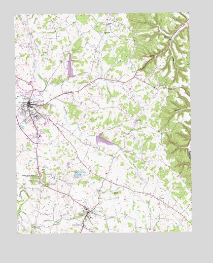
Hodgenville, KY USGS Topographic Map
Click on map above to begin viewing in our Map Viewer.

This topographic map contains these locations and features:
Feature Name Type Latitude Longitude GNIS ID View Map
Abraham Lincoln Birthplace National Historical ParkParkN37.6120°W85.6444°496556View Map
Abraham Lincoln Boyhood HomeBuildingN37.6115°W85.6380°485735View Map
Beaver Dam CreekStreamN37.5140°W85.6966°2569437View Map
Boundary OakPopulated PlaceN37.5303°W85.7377°507561View Map
BuffaloPopulated PlaceN37.5120°W85.6986°488299View Map
Buffalo Census Designated PlaceCensusN37.5081°W85.6992°2629580View Map
Buffalo Elementary SchoolSchoolN37.5092°W85.6975°2555003View Map
Buffalo Fire DepartmentBuildingN37.5095°W85.7012°2636730View Map
Buffalo Methodist Church (historical)ChurchN37.5090°W85.7007°2569440View Map
Buffalo Post OfficePost OfficeN37.5141°W85.7003°2555022View Map
Castleman CreekStreamN37.5820°W85.7287°489077View Map
City of HodgenvilleCivilN37.5668°W85.7353°2404707View Map
Craddy CreekStreamN37.5870°W85.6861°490254View Map
Fork CreekStreamN37.5878°W85.6905°492337View Map
Friendship ChurchChurchN37.6140°W85.6861°492552View Map
HodgenvillePopulated PlaceN37.5739°W85.7400°494334View Map
Hodgenville DivisionCivilN37.6171°W85.6967°1937064View Map
Hodgenville Fire DepartmentBuildingN37.5744°W85.7382°2636879View Map
Hodgenville Police DepartmentBuildingN37.5725°W85.7411°2767416View Map
JerichoPopulated PlaceN37.5187°W85.6483°508336View Map
Jericho Methodist Church (historical)ChurchN37.5184°W85.6471°2569448View Map
Jericho School (historical)SchoolN37.5181°W85.6479°2569449View Map
Kennedy School (historical)SchoolN37.6108°W85.7243°2569452View Map
Larue CountyCivilN37.5458°W85.6979°516908View Map
LaRue County Emergency Medical ServicesBuildingN37.5512°W85.7348°2719070View Map
Larue County Fire DepartmentBuildingN37.5744°W85.7383°2636880View Map
Larue County Sheriff's OfficeBuildingN37.5718°W85.7424°2767616View Map
LeafdalePopulated PlaceN37.5634°W85.6647°508433View Map
Leafdale Lookout TowerTowerN37.5562°W85.6462°2569454View Map
Leafdale Post Office (historical)Post OfficeN37.5635°W85.6643°2569455View Map
Lincoln Farm AirportAirportN37.5376°W85.7375°517401View Map
Lincoln Memorial Baptist ChurchChurchN37.5277°W85.7288°496555View Map
McDougal CreekStreamN37.5734°W85.7305°497841View Map
Oak Grove Methodist Church (historical)ChurchN37.5628°W85.6643°2569463View Map
Oriska Post Office (historical)Post OfficeN37.5970°W85.6672°2569467View Map
Otter Post Office (historical)Post OfficeN37.5058°W85.6489°2569469View Map
Pleasant Grove Baptist Church CemeteryCemeteryN37.5872°W85.6620°2569471View Map
Red Hill CemeteryCemeteryN37.5717°W85.7308°501653View Map
Reids Mill (historical)LocaleN37.5220°W85.7494°2569473View Map
Reids Mill Post Office (historical)Post OfficeN37.5209°W85.7485°2569474View Map
Saint Joachim CemeteryCemeteryN37.5828°W85.6466°502639View Map
Saint Joseph Catholic Church (historical)ChurchN37.5819°W85.6476°2569476View Map
Salem CreekStreamN37.5867°W85.7128°2555024View Map
School Number Sixteen (historical)SchoolN37.5971°W85.6675°2569479View Map
South BuffaloPopulated PlaceN37.5042°W85.7025°503895View Map
South Fork BranchStreamN37.5098°W85.7019°503907View Map
South Fork ChurchChurchN37.5042°W85.7380°503914View Map
Sportsman LakeReservoirN37.5341°W85.7052°504087View Map
Stonehouse School (historical)SchoolN37.5838°W85.6906°2569483View Map
Terhune SpringSpringN37.5226°W85.6814°505075View Map
Walters CreekStreamN37.5128°W85.7472°506199View Map
West SchoolSchoolN37.5813°W85.6401°506477View Map
White City (historical)Populated PlaceN37.5895°W85.6644°509355View Map
Wilkins CreekStreamN37.5878°W85.6905°506765View Map
Wilkins Mill (historical)LocaleN37.6178°W85.6818°2569487View Map
Wilkins Post Office (historical)Post OfficeN37.6189°W85.6844°2569488View Map
Wilkins SchoolSchoolN37.6187°W85.6839°506766View Map
Williams Airport (historical)AirportN37.5826°W85.7330°517402View Map
WXAM-AM (Buffalo)TowerN37.5303°W85.7136°517575View Map

Note: Coordinates in the location and feature list above are referenced to NAD83 datum.


Copyright (C) 2008-2025 Ryan Niemi / Sunset Dynamics ... All Rights Reserved