TopoQuest Logo
Do you find TopoQuest useful?
Help keep TopoQuest running and adding new maps/features by donating!
Bitcoin:  19c7KJd3qBynnjoSw5npx9KScwjBe4ifkT
Litecoin:  LXs6TkuXGGXo1vDsWCkWVdjQX94eUKd6ui
Home View Maps Find Maps Find Places Resources & Links


Hoffman, North Carolina Topographic Map

USGS Map Title: Hoffman, NC
USGS Map MRC: 35079A5
DRG (GeoTIFF) Download: o35079a5.tif


Neighboring USGS Topographic Map Quads:


  Norman, NC  
35079B6
 

  West End, NC  
35079B5
 

  Southern Pines, NC  
35079B4
 

  Millstone Lake, NC  
35079A6
 

  Hoffman, NC  
35079A5
 

  Pinebluff, NC  
35079A4
 

  Hamlet, NC  
34079H6
 

  Marston, NC  
34079H5
 

  Silver Hill, NC  
34079H4


Map MRC Location:

N36°
W80°
N36°
W79°
H8 H7 H6 H5 H4 H3 H2 H1
G8 G7 G6 G5 G4 G3 G2 G1
F8 F7 F6 F5 F4 F3 F2 F1
E8 E7 E6 E5 E4 E3 E2 E1
D8 D7 D6 D5 D4 D3 D2 D1
C8 C7 C6 C5 C4 C3 C2 C1
B8 B7 B6 B5 B4 B3 B2 B1
A8 A7 A6 A5 A4 A3 A2 A1
N35°
W80°
N35°
W79°

Hoffman, NC USGS 1:24K Topographic Map Preview:
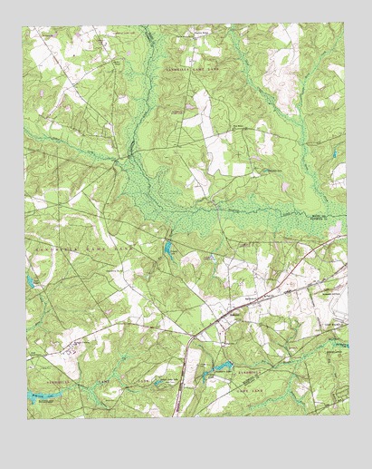
Hoffman, NC USGS Topographic Map
Click on map above to begin viewing in our Map Viewer.

This topographic map contains these locations and features:
Feature Name Type Latitude Longitude GNIS ID View Map
Big Bear BranchStreamN35.0227°W79.5039°981316View Map
Big BranchStreamN35.0663°W79.5575°981328View Map
Blue CemeteryCemeteryN35.0307°W79.5442°981622View Map
Broadacres LakeReservoirN35.0163°W79.5480°998305View Map
Broadacres Lake DamDamN35.0168°W79.5448°998304View Map
Broadacres LakesReservoirN35.0163°W79.5480°981950View Map
Crappie LakeReservoirN35.0540°W79.5691°983719View Map
Crappie Lake DamDamN35.0560°W79.5684°998346View Map
Deep CreekStreamN35.0915°W79.5162°984059View Map
Fletcher ChapelChurchN35.0352°W79.5389°1731882View Map
HoffmanPopulated PlaceN35.0324°W79.5475°1020787View Map
Hoffman Baptist ChurchChurchN35.0293°W79.5506°1731885View Map
Hoffman Elementary SchoolSchoolN35.0235°W79.5478°1006779View Map
Hoffman Fire and RescueBuildingN35.0260°W79.5604°2638416View Map
Hoffman High School (historical)SchoolN35.0382°W79.5320°1731886View Map
Hoffman Methodist Episcopal ChurchChurchN35.0299°W79.5531°1731887View Map
Horse CreekStreamN35.0638°W79.5070°987092View Map
Indian Camp LakeReservoirN35.0113°W79.5738°987343View Map
Indian Camp ParkParkN35.0104°W79.5720°987344View Map
Lake BaggetReservoirN35.0439°W79.6227°980420View Map
Long BranchStreamN35.0413°W79.5017°988889View Map
Macedonia ChurchChurchN35.0368°W79.5348°989174View Map
Mackall Army AirfieldAirportN35.0310°W79.5028°1001103View Map
McKinney LakeReservoirN35.0076°W79.6204°989598View Map
McKinney Lake National Fish HatcheryParkN35.0094°W79.6243°989599View Map
McNir ChapelChurchN35.1135°W79.5895°989643View Map
Morrison Correctional InstitutionBuildingN35.0214°W79.6074°2769840View Map
Morrison Training SchoolSchoolN35.0235°W79.6067°990273View Map
Naked CreekStreamN35.0777°W79.5787°990848View Map
Narrow RidgePopulated PlaceN35.1204°W79.5581°990864View Map
New Bethel ChurchChurchN35.0918°W79.5437°990928View Map
Ocre Grove ChurchChurchN35.0471°W79.5875°991516View Map
P R Rankin DamDamN35.0785°W79.5298°998365View Map
Ranchin LakeReservoirN35.0782°W79.5309°993023View Map
Saint Johns ChurchChurchN35.1221°W79.6173°993935View Map
Taylor Memorial CemeteryCemeteryN35.1207°W79.5589°1731879View Map
Taylor Memorial ChurchChurchN35.1207°W79.5587°995892View Map
Towers ForkStreamN35.0177°W79.5192°996177View Map
Town of HoffmanCivilN35.0313°W79.5491°2405848View Map
Township of BeaverdamCivilN35.0468°W79.6172°1027094View Map
Watson CemeteryCemeteryN35.0054°W79.5906°996864View Map

Note: Coordinates in the location and feature list above are referenced to NAD83 datum.


Copyright (C) 2008-2025 Ryan Niemi / Sunset Dynamics ... All Rights Reserved