TopoQuest Logo
Do you find TopoQuest useful?
Help keep TopoQuest running and adding new maps/features by donating!
Bitcoin:  19c7KJd3qBynnjoSw5npx9KScwjBe4ifkT
Litecoin:  LXs6TkuXGGXo1vDsWCkWVdjQX94eUKd6ui
Home View Maps Find Maps Find Places Resources & Links


Hohenlinden, Mississippi Topographic Map

USGS Map Title: Hohenlinden, MS
USGS Map MRC: 33089F2
DRG (GeoTIFF) Download: o33089f2.tif


Neighboring USGS Topographic Map Quads:


  Calhoun City, MS  
33089G3
 

  Atlanta, MS  
33089G2
 

  Woodland, MS  
33089G1
 

  Bellefontaine, MS  
33089F3
 

  Hohenlinden, MS  
33089F2
 

  Mantee, MS  
33089F1
 

  Eupora, MS  
33089E3
 

  Sapa, MS  
33089E2
 

  Maben, MS  
33089E1


Map MRC Location:

N34°
W90°
N34°
W89°
H8 H7 H6 H5 H4 H3 H2 H1
G8 G7 G6 G5 G4 G3 G2 G1
F8 F7 F6 F5 F4 F3 F2 F1
E8 E7 E6 E5 E4 E3 E2 E1
D8 D7 D6 D5 D4 D3 D2 D1
C8 C7 C6 C5 C4 C3 C2 C1
B8 B7 B6 B5 B4 B3 B2 B1
A8 A7 A6 A5 A4 A3 A2 A1
N33°
W90°
N33°
W89°

Hohenlinden, MS USGS 1:24K Topographic Map Preview:
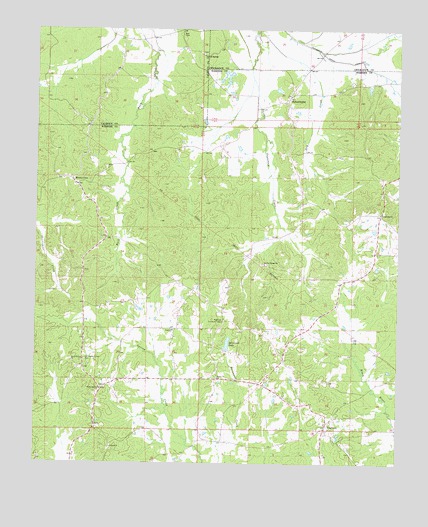
Hohenlinden, MS USGS Topographic Map
Click on map above to begin viewing in our Map Viewer.

This topographic map contains these locations and features:
Feature Name Type Latitude Longitude GNIS ID View Map
American Legion Lake DamDamN33.6585°W89.1767°682274View Map
Ball CemeteryCemeteryN33.7484°W89.1998°666488View Map
Beasley HillsRangeN33.6710°W89.2167°710820View Map
ClarksonPopulated PlaceN33.6354°W89.1495°668525View Map
Clarkson - Fame Volunteer Fire DepartmentBuildingN33.6372°W89.1482°2665931View Map
Clarkson Baptist ChurchChurchN33.6354°W89.1501°682828View Map
Clarkson CemeteryCemeteryN33.6354°W89.1489°705677View Map
Clarkson Methodist ChurchChurchN33.6368°W89.1498°682829View Map
Clarkson School (historical)SchoolN33.6357°W89.1495°705678View Map
Cross Roads CemeteryCemeteryN33.6979°W89.1323°705680View Map
Cross Roads School (historical)SchoolN33.6973°W89.1320°705681View Map
Crossroads ChurchChurchN33.6973°W89.1315°668982View Map
Double Springs CemeteryCemeteryN33.6826°W89.1703°705683View Map
Double Springs ChurchChurchN33.6826°W89.1709°669353View Map
Dry CreekStreamN33.7487°W89.1740°669422View Map
FamePopulated PlaceN33.6640°W89.2015°705691View Map
Fame ChurchChurchN33.6635°W89.2026°669905View Map
Fame School (historical)SchoolN33.6643°W89.2023°705692View Map
First Free Will Baptist ChurchChurchN33.6601°W89.1634°682837View Map
Hebron CemeteryCemeteryN33.6290°W89.2245°705695View Map
Hebron ChurchChurchN33.6296°W89.2237°671076View Map
HohenlindenPopulated PlaceN33.7290°W89.1637°671274View Map
Hohenlinden Baptist ChurchChurchN33.7312°W89.1626°710108View Map
Little Black (historical)LocaleN33.6376°W89.2292°682845View Map
Monte Vista Baptist ChurchChurchN33.7054°W89.2367°682850View Map
MontevistaPopulated PlaceN33.7051°W89.2356°673737View Map
Montevista CemeteryCemeteryN33.7048°W89.2365°705707View Map
Montevista School (historical)SchoolN33.7048°W89.2373°705708View Map
Old Shady Grove CemeteryCemeteryN33.6548°W89.2326°675254View Map
Pat Gibson Lake DamDamN33.7318°W89.1334°682317View Map
Pine Chapel (historical)ChurchN33.6360°W89.1490°705717View Map
Pine Chapel School (historical)SchoolN33.6357°W89.1490°705718View Map
Popular Springs (historical)LocaleN33.6723°W89.2126°705722View Map
Popular Springs ChurchChurchN33.7426°W89.1923°676251View Map
Savannah LakeReservoirN33.6596°W89.1838°677443View Map
Savannah Lake DamDamN33.6585°W89.1834°682275View Map
Shady Grove CemeteryCemeteryN33.6548°W89.2376°705728View Map
Shady Grove ChurchChurchN33.6543°W89.2376°677583View Map
Shady Grove School (historical)SchoolN33.6548°W89.2331°705729View Map
Supervisor District 5CivilN33.6687°W89.1273°712138View Map
Tabbs Chapel School (historical)SchoolN33.7037°W89.2490°705734View Map
Topisaw Watershed Structure Y-27-15 DamDamN33.7334°W89.1784°682319View Map
Unity ChurchChurchN33.6501°W89.1867°679138View Map
Webster Lookout TowerTowerN33.6660°W89.1853°711331View Map
White Hill ChurchChurchN33.6462°W89.2270°679587View Map
Woodland Academy (historical)SchoolN33.6357°W89.1492°705741View Map

Note: Coordinates in the location and feature list above are referenced to NAD83 datum.


Copyright (C) 2008-2024 Ryan Niemi / Sunset Dynamics ... All Rights Reserved