TopoQuest Logo
Do you find TopoQuest useful?
Help keep TopoQuest running and adding new maps/features by donating!
Bitcoin:  19c7KJd3qBynnjoSw5npx9KScwjBe4ifkT
Litecoin:  LXs6TkuXGGXo1vDsWCkWVdjQX94eUKd6ui
Home View Maps Find Maps Find Places Resources & Links


Hopeville, West Virginia Topographic Map

USGS Map Title: Hopeville, WV
USGS Map MRC: 38079H3
DRG (GeoTIFF) Download: o38079h3.tif


Neighboring USGS Topographic Map Quads:


  Blackwater Falls, WV  
39079A4
 

  Blackbird Knob, WV  
39079A3
 

  Maysville, WV  
39079A2
 

  Laneville, WV  
38079H4
 

  Hopeville, WV  
38079H3
 

  Petersburg West, WV  
38079H2
 

  Onego, WV  
38079G4
 

  Upper Tract, WV  
38079G3
 

  Mozer, WV  
38079G2


Map MRC Location:

N39°
W80°
N39°
W79°
H8 H7 H6 H5 H4 H3 H2 H1
G8 G7 G6 G5 G4 G3 G2 G1
F8 F7 F6 F5 F4 F3 F2 F1
E8 E7 E6 E5 E4 E3 E2 E1
D8 D7 D6 D5 D4 D3 D2 D1
C8 C7 C6 C5 C4 C3 C2 C1
B8 B7 B6 B5 B4 B3 B2 B1
A8 A7 A6 A5 A4 A3 A2 A1
N38°
W80°
N38°
W79°

Hopeville, WV USGS 1:24K Topographic Map Preview:
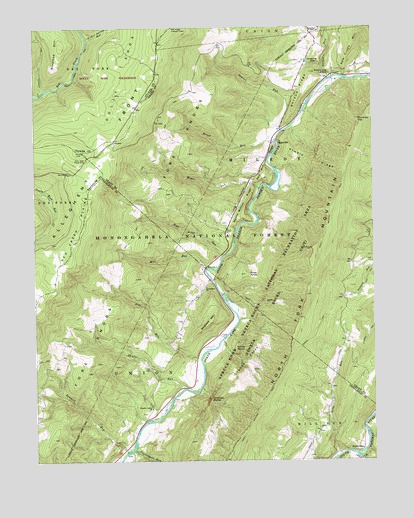
Hopeville, WV USGS Topographic Map
Click on map above to begin viewing in our Map Viewer.

This topographic map contains these locations and features:
Feature Name Type Latitude Longitude GNIS ID View Map
Bell Knob Lookout TowerTowerN38.9998°W79.3228°1557808View Map
Big RunStreamN38.9993°W79.2673°1550334View Map
Breathed MountainSummitN38.9948°W79.3642°1553969View Map
Broad RunStreamN38.9673°W79.2859°1550474View Map
Carr School (historical)SchoolN38.9018°W79.3331°1677595View Map
Champe KnobsSummitN38.9029°W79.2970°1554106View Map
Champe RocksPillarN38.8915°W79.3117°1550671View Map
Chimney TopPillarN38.9729°W79.2556°1550706View Map
Dolly Sods Picnic AreaParkN38.9618°W79.3550°1550941View Map
Fisher Spring RunStreamN38.9971°W79.3548°1551115View Map
High Ridge RunStreamN38.9340°W79.3053°1551435View Map
HopevillePopulated PlaceN38.9673°W79.2867°1554739View Map
Hopeville GapGapN38.9893°W79.2712°1551492View Map
Hopeville Post Office (historical)Post OfficeN38.9673°W79.2867°1697247View Map
Hopeville School (historical)SchoolN38.9834°W79.2698°1557011View Map
Jordan RunStreamN38.9851°W79.2659°1551612View Map
KettermanPopulated PlaceN38.8782°W79.2542°1554866View Map
Kimble RidgeRidgeN38.9607°W79.2717°1551648View Map
Long HollowValleyN38.9548°W79.2950°1551919View Map
Long RunStreamN38.8765°W79.2634°1551926View Map
Maple Dale School (historical)SchoolN38.8771°W79.2603°1677607View Map
Mill RunStreamN38.9309°W79.3098°1552125View Map
Mill SpringSpringN38.9782°W79.2756°1677870View Map
Moyer RunStreamN38.9534°W79.2914°1552247View Map
North Fork ChurchChurchN38.9254°W79.3112°1552330View Map
Pleasant Valley ChurchChurchN38.8901°W79.3320°1552511View Map
Powdermill RunStreamN38.8798°W79.3375°1552552View Map
Red Bud RidgeRidgeN38.9601°W79.2895°1552598View Map
Red Creek PlainsFlatN38.9418°W79.3575°1552603View Map
Red Creek TrailTrailN38.9857°W79.3598°1552604View Map
Redman TrailTrailN38.9126°W79.2709°1552622View Map
River KnobSummitN38.9287°W79.2967°1552669View Map
Round Bottom RidgeRidgeN38.9484°W79.2970°1552743View Map
Samuel RunStreamN38.9698°W79.2831°1552787View Map
Sawmill RunStreamN38.8779°W79.3412°1552810View Map
Shafter RunStreamN38.8959°W79.3187°1552841View Map
Shroud RidgeRidgeN38.9818°W79.2762°1552885View Map
Skidmore MountainSummitN38.9154°W79.3100°1555638View Map
Smith Mountain School (historical)SchoolN38.9115°W79.3637°1677615View Map
South Prong TrailTrailN38.9476°W79.3698°1552985View Map
Spruce Knob-Seneca Rocks National Recreation AreaParkN38.8815°W79.2981°1553568View Map
Stonecoal RunStreamN38.9809°W79.3725°1553070View Map
Tool RunStreamN38.9212°W79.3034°1548171View Map
Trout Rocks SpringSpringN38.9251°W79.3081°1677738View Map
Yellow RocksPillarN38.9073°W79.2989°1553533View Map
Zeke RunStreamN38.9073°W79.3100°1553541View Map

Note: Coordinates in the location and feature list above are referenced to NAD83 datum.


Copyright (C) 2008-2025 Ryan Niemi / Sunset Dynamics ... All Rights Reserved