TopoQuest Logo
Do you find TopoQuest useful?
Help keep TopoQuest running and adding new maps/features by donating!
Bitcoin:  19c7KJd3qBynnjoSw5npx9KScwjBe4ifkT
Litecoin:  LXs6TkuXGGXo1vDsWCkWVdjQX94eUKd6ui
Home View Maps Find Maps Find Places Resources & Links


Bagdad, Arizona Topographic Map

USGS Map Title: Bagdad, AZ
USGS Map MRC: 34113E2
DRG (GeoTIFF) Download: o34113e2.tif


Neighboring USGS Topographic Map Quads:


  Negro Ed, AZ  
34113F3
 

  Bozarth Mesa, AZ  
34113F2
 

  Behm Mesa, AZ  
34113F1
 

  Grayback Mountains, AZ  
34113E3
 

  Bagdad, AZ  
34113E2
 

  Big Shipp Mountain, AZ  
34113E1
 

  Arrastra Mountain NE, AZ  
34113D3
 

  Thorn Peak, AZ  
34113D2
 

  Malpais Mesa NE, AZ  
34113D1


Map MRC Location:

N35°
W114°
N35°
W113°
H8 H7 H6 H5 H4 H3 H2 H1
G8 G7 G6 G5 G4 G3 G2 G1
F8 F7 F6 F5 F4 F3 F2 F1
E8 E7 E6 E5 E4 E3 E2 E1
D8 D7 D6 D5 D4 D3 D2 D1
C8 C7 C6 C5 C4 C3 C2 C1
B8 B7 B6 B5 B4 B3 B2 B1
A8 A7 A6 A5 A4 A3 A2 A1
N34°
W114°
N34°
W113°

Bagdad, AZ USGS 1:24K Topographic Map Preview:
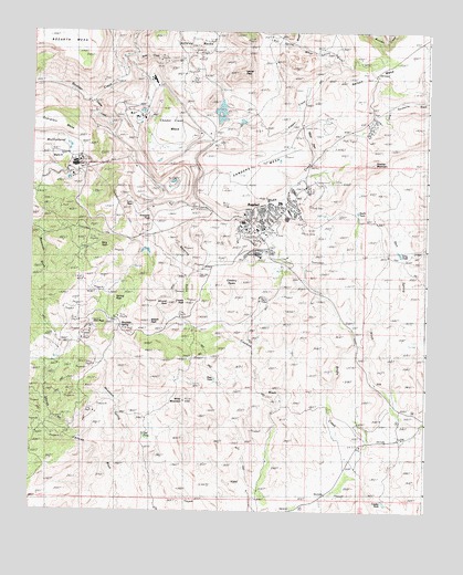
Bagdad, AZ USGS Topographic Map
Click on map above to begin viewing in our Map Viewer.

This topographic map contains these locations and features:
Feature Name Type Latitude Longitude GNIS ID View Map
Alum CreekStreamN34.5906°W113.2188°619View Map
BagdadPopulated PlaceN34.5811°W113.2046°949View Map
Bagdad AirportAirportN34.5948°W113.1689°45303View Map
Bagdad Census Designated PlaceCensusN34.5771°W113.1770°2407792View Map
Bagdad Community Health CenterHospitalN34.5775°W113.1831°21163View Map
Bagdad Elementary SchoolSchoolN34.5754°W113.1834°21161View Map
Bagdad High SchoolSchoolN34.5739°W113.1837°21162View Map
Bagdad Open Pit MineMineN34.5847°W113.2119°21164View Map
Bagdad Post OfficePost OfficeN34.5737°W113.1794°44877View Map
Bagdad Tailings DamDamN34.5750°W113.1508°21165View Map
Bevering GulchValleyN34.5789°W113.2085°1275View Map
Black MesaSummitN34.6072°W113.2119°1545View Map
Butte CreekStreamN34.6189°W113.2183°2301View Map
Centipede MesaSummitN34.6003°W113.2399°2692View Map
Comstock-Dexter MineMineN34.6170°W113.2105°3153View Map
Copper CreekStreamN34.6070°W113.2321°3223View Map
Copper Creek MesaSummitN34.6009°W113.2071°3225View Map
Copper King MineMineN34.5697°W113.2299°3232View Map
Cowboy MineMineN34.5553°W113.1783°3460View Map
Cowboy PeaksSummitN34.5597°W113.1835°3461View Map
Crosby PeakSummitN34.5542°W113.2066°3585View Map
Crosby TankReservoirN34.5025°W113.1382°3586View Map
Daniel C Lincoln Elementary School (historical)SchoolN34.5805°W113.1722°21246View Map
Dick PeakSummitN34.5492°W113.2302°3940View Map
First Baptist ChurchChurchN34.5784°W113.1757°2670934View Map
Granite MountainSummitN34.5906°W113.1427°5245View Map
Hillside RocksSummitN34.6214°W113.1974°5824View Map
Hilltop Community ChurchChurchN34.5731°W113.1817°2671131View Map
Kimberly PeakSummitN34.5767°W113.2130°6691View Map
King PeakSummitN34.5653°W113.2305°6698View Map
Kyeke MineMineN34.6122°W113.2283°6789View Map
Lawler PeakSummitN34.6139°W113.1860°6923View Map
Lucy PeakSummitN34.5789°W113.2205°7536View Map
Maroney GulchValleyN34.5789°W113.2085°7719View Map
Mesa PassGapN34.5961°W113.1630°7901View Map
Mesa View Golf CourseLocaleN34.5766°W113.1742°2670578View Map
Miller MountainSummitN34.5286°W113.2019°8063View Map
Mineral CreekStreamN34.5814°W113.2121°8099View Map
Mineral PeakSummitN34.5534°W113.2121°8106View Map
Mountain SpringSpringN34.5484°W113.2213°8331View Map
Mulholland BasinBasinN34.5928°W113.2416°8433View Map
Nelson MesaSummitN34.6131°W113.1421°8573View Map
Niagara CreekStreamN34.6017°W113.2280°8648View Map
Old Dick MineMineN34.5481°W113.2216°32497View Map
Saint Francis Catholic ChurchChurchN34.5757°W113.1786°2671282View Map
Sanders MesaSummitN34.5892°W113.1783°10912View Map
Spring CreekStreamN34.5878°W113.2033°11701View Map
Spring PeakSummitN34.5550°W113.2235°11709View Map
Sycamore Mobile Home ParkPopulated PlaceN34.6007°W113.1431°2670298View Map
Waters PeakSummitN34.5495°W113.2119°13402View Map
White SpringSpringN34.6214°W113.1688°13670View Map
White Spring WashStreamN34.6222°W113.1674°13672View Map
Yavapai County Sheriff's Office SubstationBuildingN34.5700°W113.1768°2751590View Map

Note: Coordinates in the location and feature list above are referenced to NAD83 datum.


Copyright (C) 2008-2025 Ryan Niemi / Sunset Dynamics ... All Rights Reserved