TopoQuest Logo
Do you find TopoQuest useful?
Help keep TopoQuest running and adding new maps/features by donating!
Bitcoin:  19c7KJd3qBynnjoSw5npx9KScwjBe4ifkT
Litecoin:  LXs6TkuXGGXo1vDsWCkWVdjQX94eUKd6ui
Home View Maps Find Maps Find Places Resources & Links


Hough Springs, California Topographic Map

USGS Map Title: Hough Springs, CA
USGS Map MRC: 39122B5
DRG (GeoTIFF) Download: o39122b5.tif


Neighboring USGS Topographic Map Quads:


  Fouts Springs, CA  
39122C6
 

  Gilmore Peak, CA  
39122C5
 

  Lodoga, CA  
39122C4
 

  Bartlett Springs, CA  
39122B6
 

  Hough Springs, CA  
39122B5
 

  Leesville, CA  
39122B4
 

  Clearlake Oaks, CA  
39122A6
 

  Benmore Canyon, CA  
39122A5
 

  Wilbur Springs, CA  
39122A4


Map MRC Location:

N40°
W123°
N40°
W122°
H8 H7 H6 H5 H4 H3 H2 H1
G8 G7 G6 G5 G4 G3 G2 G1
F8 F7 F6 F5 F4 F3 F2 F1
E8 E7 E6 E5 E4 E3 E2 E1
D8 D7 D6 D5 D4 D3 D2 D1
C8 C7 C6 C5 C4 C3 C2 C1
B8 B7 B6 B5 B4 B3 B2 B1
A8 A7 A6 A5 A4 A3 A2 A1
N39°
W123°
N39°
W122°

Hough Springs, CA USGS 1:24K Topographic Map Preview:
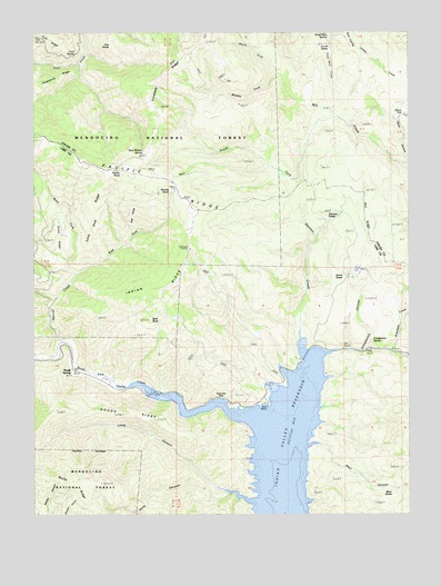
Hough Springs, CA USGS Topographic Map
Click on map above to begin viewing in our Map Viewer.

This topographic map contains these locations and features:
Feature Name Type Latitude Longitude GNIS ID View Map
Barkerville (historical)Populated PlaceN39.1543°W122.5625°256524View Map
Bean CanyonValleyN39.1429°W122.5361°266420View Map
Bean GladeFlatN39.1310°W122.5066°256613View Map
Bear Wallow SpringSpringN39.2191°W122.5895°256726View Map
Complexion CanyonValleyN39.1679°W122.5136°258622View Map
Complexion SpringSpringN39.1700°W122.5133°258623View Map
Corral ValleyBasinN39.2466°W122.5344°258739View Map
Davis FlatFlatN39.2288°W122.5030°222051View Map
Dead Shot CreekStreamN39.2485°W122.5275°259121View Map
Dead Shot SpringSpringN39.2489°W122.5279°259122View Map
East Fork Spanish CreekStreamN39.1868°W122.6117°259751View Map
East GladeFlatN39.2024°W122.5864°259759View Map
Ford SpringSpringN39.2446°W122.6120°260246View Map
Hells CanyonValleyN39.1304°W122.5603°261251View Map
Hough RidgeRidgeN39.1513°W122.5958°261563View Map
Hough SpringsPopulated PlaceN39.1624°W122.6122°261564View Map
Indian RidgeRidgeN39.1841°W122.5830°261757View Map
Kanaka GladeFlatN39.2071°W122.5800°262072View Map
Kilpepper CreekStreamN39.1674°W122.5069°266882View Map
Kowalski RanchLocaleN39.1654°W122.5383°276267View Map
Lone Pine RidgeRidgeN39.2029°W122.6044°262807View Map
Long CanyonValleyN39.1291°W122.5519°266940View Map
Lovelady RidgeRidgeN39.2313°W122.5864°266349View Map
Middle Fork Mill CreekStreamN39.2396°W122.5444°263533View Map
North Fork Mill CreekStreamN39.2391°W122.5447°264185View Map
Pacific PointSummitN39.2143°W122.6005°264432View Map
Pacific Point Guard Station (historical)LocaleN39.2141°W122.5978°1666660View Map
Red RidgeRidgeN39.2085°W122.5150°265314View Map
South Fork Mill CreekStreamN39.2279°W122.5250°267478View Map
Spanish CreekStreamN39.1693°W122.6150°267546View Map
Split RockSummitN39.1752°W122.5869°267574View Map
Stanton CreekStreamN39.1660°W122.5372°267675View Map
Stanton GladeFlatN39.2010°W122.5217°267676View Map
Stove GladeFlatN39.1863°W122.5211°267799View Map
Tule GladeFlatN39.2452°W122.5983°268453View Map
West Fork Spanish CreekStreamN39.1877°W122.6114°268917View Map
Wyley GladeFlatN39.1929°W122.6139°269323View Map

Note: Coordinates in the location and feature list above are referenced to NAD83 datum.


Copyright (C) 2008-2025 Ryan Niemi / Sunset Dynamics ... All Rights Reserved