TopoQuest Logo
Do you find TopoQuest useful?
Help keep TopoQuest running and adding new maps/features by donating!
Bitcoin:  19c7KJd3qBynnjoSw5npx9KScwjBe4ifkT
Litecoin:  LXs6TkuXGGXo1vDsWCkWVdjQX94eUKd6ui
Home View Maps Find Maps Find Places Resources & Links


Clearlake Oaks, California Topographic Map

USGS Map Title: Clearlake Oaks, CA
USGS Map MRC: 39122A6
DRG (GeoTIFF) Download: o39122a6.tif


Neighboring USGS Topographic Map Quads:


  Bartlett Mountain, CA  
39122B7
 

  Bartlett Springs, CA  
39122B6
 

  Hough Springs, CA  
39122B5
 

  Lucerne, CA  
39122A7
 

  Clearlake Oaks, CA  
39122A6
 

  Benmore Canyon, CA  
39122A5
 

  Kelseyville, CA  
38122H7
 

  Clearlake Highlands, CA  
38122H6
 

  Lower Lake, CA  
38122H5


Map MRC Location:

N40°
W123°
N40°
W122°
H8 H7 H6 H5 H4 H3 H2 H1
G8 G7 G6 G5 G4 G3 G2 G1
F8 F7 F6 F5 F4 F3 F2 F1
E8 E7 E6 E5 E4 E3 E2 E1
D8 D7 D6 D5 D4 D3 D2 D1
C8 C7 C6 C5 C4 C3 C2 C1
B8 B7 B6 B5 B4 B3 B2 B1
A8 A7 A6 A5 A4 A3 A2 A1
N39°
W123°
N39°
W122°

Clearlake Oaks, CA USGS 1:24K Topographic Map Preview:
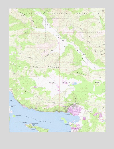
Clearlake Oaks, CA USGS Topographic Map
Click on map above to begin viewing in our Map Viewer.

This topographic map contains these locations and features:
Feature Name Type Latitude Longitude GNIS ID View Map
Anderson IslandIslandN39.0160°W122.7439°256239View Map
Buckingham PointCapeN39.0255°W122.7492°257631View Map
Butler RanchLocaleN39.0552°W122.6925°1666653View Map
California Department of Forestry and Fire Protection Clearlake Oaks StationBuildingN39.0237°W122.7117°2622250View Map
Clear Lake KeysPopulated PlaceN39.0207°W122.6625°1766089View Map
Clear Lake QuarryMineN39.0169°W122.6325°2676086View Map
Clearlake OaksPopulated PlaceN39.0263°W122.6719°1667849View Map
Clearlake Oaks Census Designated PlaceCensusN39.0218°W122.6593°2407631View Map
Clearlake Oaks Post OfficePost OfficeN39.0262°W122.6610°1766092View Map
East Lake Elementary SchoolSchoolN39.0284°W122.6668°259765View Map
Eastlake (historical)Populated PlaceN39.0077°W122.6678°1766096View Map
Evans PeakSummitN39.1229°W122.6767°266695View Map
Fruit IslandIslandN39.0088°W122.7336°260432View Map
Fuller CanyonValleyN39.1052°W122.7211°260441View Map
Garner RanchLocaleN39.0924°W122.6808°260488View Map
GlenhavenPopulated PlaceN39.0263°W122.7330°1656047View Map
Glenhaven Post OfficePost OfficeN39.0266°W122.7322°1766101View Map
High ValleyValleyN39.0443°W122.6680°261338View Map
High Valley RidgeRidgeN39.0643°W122.6908°261339View Map
Honeymoon CoveBayN39.0035°W122.7203°261438View Map
Indian BeachBeachN39.0230°W122.7244°261711View Map
Kennedy RanchLocaleN39.0746°W122.6517°262135View Map
Lake County Fire StationBuildingN39.0009°W122.7107°2622007View Map
Long Valley RidgeRidgeN39.1174°W122.7300°262891View Map
Northshore Fire Protection District Station 75 Clearlake OaksBuildingN39.0248°W122.6732°2621841View Map
Northshore Fire Protection District Station 76 GlenhavenBuildingN39.0269°W122.7334°2622008View Map
Paradise CoveBayN39.0063°W122.7203°264508View Map
Pluth Ranch (historical)LocaleN39.0288°W122.6294°1666661View Map
Rattlesnake IslandIslandN39.0099°W122.6789°265216View Map
Reister CanyonValleyN39.1118°W122.6317°265368View Map
Reister KnollSummitN39.1213°W122.6269°267174View Map
Rose CanyonValleyN39.1185°W122.7069°265570View Map
Round MountainSummitN39.0488°W122.6350°1656266View Map
Saint Anthonys Catholic ChurchChurchN39.0138°W122.6383°1766146View Map
Schindler CreekStreamN39.0227°W122.6669°265909View Map
Schindler RanchLocaleN39.0438°W122.6683°1666664View Map
Shaw RanchLocaleN39.0463°W122.7094°1666665View Map
South Fork Long Valley CreekStreamN39.1016°W122.6947°267473View Map
Springer FlatFlatN39.1104°W122.6317°267608View Map
Stubbs IslandIslandN39.0180°W122.6714°267817View Map
Sulphur Bank MineMineN39.0038°W122.6664°267887View Map
Sulphur Bank PointCapeN39.0082°W122.7228°267888View Map
Sulphur Bank RancheriaCivilN39.0087°W122.6703°267889View Map
Sulphur CanyonValleyN39.0813°W122.6908°235699View Map
Weekend IslandIslandN39.0102°W122.7367°268840View Map
Wolf Creek RidgeRidgeN39.0874°W122.6417°269270View Map

Note: Coordinates in the location and feature list above are referenced to NAD83 datum.


Copyright (C) 2008-2025 Ryan Niemi / Sunset Dynamics ... All Rights Reserved