TopoQuest Logo
Do you find TopoQuest useful?
Help keep TopoQuest running and adding new maps/features by donating!
Bitcoin:  19c7KJd3qBynnjoSw5npx9KScwjBe4ifkT
Litecoin:  LXs6TkuXGGXo1vDsWCkWVdjQX94eUKd6ui
Home View Maps Find Maps Find Places Resources & Links


Houston, Arkansas Topographic Map

USGS Map Title: Houston, AR
USGS Map MRC: 35092A6
DRG (GeoTIFF) Download: o35092a6.tif


Neighboring USGS Topographic Map Quads:


  Morrilton West, AR  
35092B7
 

  Morrilton East, AR  
35092B6
 

  Menifee, AR  
35092B5
 

  Perryville, AR  
35092A7
 

  Houston, AR  
35092A6
 

  Gleason, AR  
35092A5
 

  Thornburg, AR  
34092H7
 

  Martindale, AR  
34092H6
 

  Fourche, AR  
34092H5


Map MRC Location:

N36°
W93°
N36°
W92°
H8 H7 H6 H5 H4 H3 H2 H1
G8 G7 G6 G5 G4 G3 G2 G1
F8 F7 F6 F5 F4 F3 F2 F1
E8 E7 E6 E5 E4 E3 E2 E1
D8 D7 D6 D5 D4 D3 D2 D1
C8 C7 C6 C5 C4 C3 C2 C1
B8 B7 B6 B5 B4 B3 B2 B1
A8 A7 A6 A5 A4 A3 A2 A1
N35°
W93°
N35°
W92°

Houston, AR USGS 1:24K Topographic Map Preview:
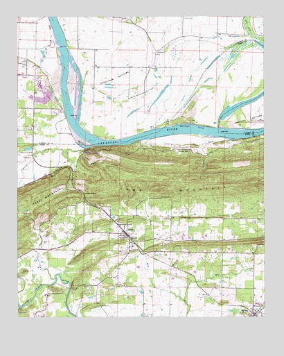
Houston, AR USGS Topographic Map
Click on map above to begin viewing in our Map Viewer.

This topographic map contains these locations and features:
Feature Name Type Latitude Longitude GNIS ID View Map
Anne Watson Elementary SchoolSchoolN35.0281°W92.6432°65182View Map
Ballard CreekStreamN35.0740°W92.6393°46062View Map
Bethel School (historical)SchoolN35.0315°W92.6727°65191View Map
BigelowPopulated PlaceN35.0012°W92.6299°46615View Map
Bigelow Fire StationBuildingN35.0009°W92.6290°2116151View Map
Bland CemeteryCemeteryN35.0312°W92.7374°83593View Map
Bunker HillPopulated PlaceN35.0698°W92.6688°76466View Map
Copperas GapGapN35.0512°W92.7166°48032View Map
Copperas Gap (historical)Populated PlaceN35.0593°W92.7224°65200View Map
Copperas Spring School (historical)SchoolN35.0590°W92.7218°65201View Map
Council Bluffs BridgeBridgeN35.0120°W92.7238°65202View Map
Cox LakeSwampN35.1179°W92.6307°76699View Map
Cypress CreekStreamN35.0704°W92.7160°48307View Map
Cypress Creek ParkParkN35.0695°W92.7160°65204View Map
HoustonPopulated PlaceN35.0334°W92.6946°50355View Map
Houston CemeteryCemeteryN35.0495°W92.6774°83602View Map
Houston City PoliceBuildingN35.0336°W92.6949°2118798View Map
Houston Post OfficePost OfficeN35.0339°W92.6952°2781864View Map
Houston Volunteer Fire DepartmentBuildingN35.0338°W92.6950°2116605View Map
Leach CemeteryCemeteryN35.0340°W92.7368°83603View Map
May CemeteryCemeteryN35.0129°W92.7132°83606View Map
Moab (historical)Populated PlaceN35.0126°W92.7404°65232View Map
Morrilton CutoffChannelN35.0795°W92.6621°52212View Map
Sandtown (historical)Populated PlaceN35.0898°W92.7113°66219View Map
Sandtown BottomsFlatN35.0995°W92.7007°54562View Map
Toms MountainRidgeN35.0562°W92.6302°55604View Map
Town of HoustonCivilN35.0350°W92.6946°2405869View Map
Township of HoustonCivilN35.0419°W92.6918°68932View Map
West Fork Mill CreekStreamN35.0070°W92.6663°56185View Map
White BranchStreamN35.0693°W92.7179°56243View Map

Note: Coordinates in the location and feature list above are referenced to NAD83 datum.


Copyright (C) 2008-2025 Ryan Niemi / Sunset Dynamics ... All Rights Reserved