TopoQuest Logo
Do you find TopoQuest useful?
Help keep TopoQuest running and adding new maps/features by donating!
Bitcoin:  19c7KJd3qBynnjoSw5npx9KScwjBe4ifkT
Litecoin:  LXs6TkuXGGXo1vDsWCkWVdjQX94eUKd6ui
Home View Maps Find Maps Find Places Resources & Links


Martindale, Arkansas Topographic Map

USGS Map Title: Martindale, AR
USGS Map MRC: 34092H6
DRG (GeoTIFF) Download: o34092h6.tif


Neighboring USGS Topographic Map Quads:


  Perryville, AR  
35092A7
 

  Houston, AR  
35092A6
 

  Gleason, AR  
35092A5
 

  Thornburg, AR  
34092H7
 

  Martindale, AR  
34092H6
 

  Fourche, AR  
34092H5
 

  Paron, AR  
34092G7
 

  Fourche SW, AR  
34092G6
 

  Ferndale, AR  
34092G5


Map MRC Location:

N35°
W93°
N35°
W92°
H8 H7 H6 H5 H4 H3 H2 H1
G8 G7 G6 G5 G4 G3 G2 G1
F8 F7 F6 F5 F4 F3 F2 F1
E8 E7 E6 E5 E4 E3 E2 E1
D8 D7 D6 D5 D4 D3 D2 D1
C8 C7 C6 C5 C4 C3 C2 C1
B8 B7 B6 B5 B4 B3 B2 B1
A8 A7 A6 A5 A4 A3 A2 A1
N34°
W93°
N34°
W92°

Martindale, AR USGS 1:24K Topographic Map Preview:
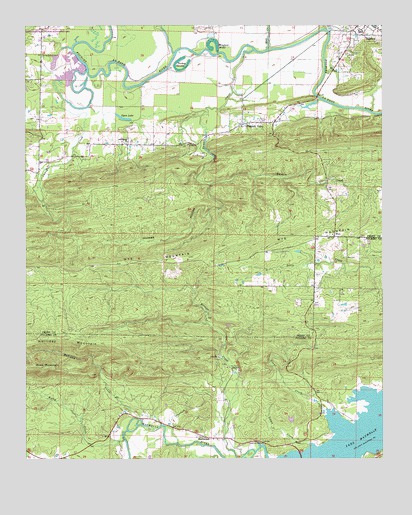
Martindale, AR USGS Topographic Map
Click on map above to begin viewing in our Map Viewer.

This topographic map contains these locations and features:
Feature Name Type Latitude Longitude GNIS ID View Map
Bellevue (historical)Populated PlaceN34.9318°W92.7016°65189View Map
Bigelow High SchoolSchoolN34.9978°W92.6332°2039189View Map
Caney CreekValleyN34.9870°W92.7291°47434View Map
Crossroads (historical)Populated PlaceN34.8862°W92.6349°67467View Map
Deerlick CreekStreamN34.8798°W92.6971°48460View Map
East End High SchoolSchoolN34.9981°W92.6329°65208View Map
Francis LakeReservoirN34.9770°W92.6505°81096View Map
Francis Lake DamDamN34.9784°W92.6485°81095View Map
GraytownPopulated PlaceN34.9954°W92.6363°65212View Map
Highland School (historical)SchoolN34.9387°W92.6482°67531View Map
Holliday CreekStreamN34.8851°W92.7099°50199View Map
Holliday MountainRidgeN34.9101°W92.7354°50200View Map
Holmes HollowValleyN34.9540°W92.6863°50261View Map
Lamb CreekStreamN34.8793°W92.6510°50963View Map
Long HollowValleyN34.8751°W92.6832°51427View Map
MartindalePopulated PlaceN34.8818°W92.6882°51714View Map
May ShoalsBarN34.9987°W92.7199°65230View Map
Mill CreekStreamN34.9929°W92.6657°52016View Map
Moyer MountainSummitN34.9056°W92.6477°67592View Map
Oak GrovePopulated PlaceN34.9659°W92.7143°65240View Map
Oak Grove ChurchChurchN34.9662°W92.7141°52910View Map
Oak Grove School (historical)SchoolN34.9662°W92.7143°65241View Map
Open LakeLakeN34.9735°W92.7161°75812View Map
Orchard (historical)Populated PlaceN34.9320°W92.6771°65242View Map
Pearson FieldAirportN34.9891°W92.6381°2650791View Map
Pleasant ValleyPopulated PlaceN34.9715°W92.6743°53605View Map
Pleasant Valley School (historical)SchoolN34.9712°W92.6743°65250View Map
Rankin (historical)Populated PlaceN34.9618°W92.6849°65251View Map
Rankin CreekStreamN34.9929°W92.6704°53895View Map
Rothy CreekStreamN34.8815°W92.7160°78219View Map
Sleepy Hollow ParkParkN34.8797°W92.6672°2560043View Map
Suck MountainSummitN34.9015°W92.7435°73747View Map
Town of BigelowCivilN34.9982°W92.6311°2405263View Map
Township of KenneyCivilN34.9742°W92.6494°68933View Map
Township of Maumelle (historical)CivilN34.8806°W92.6543°68398View Map
Township of RankinCivilN34.9579°W92.7336°68939View Map
Turkey SwampSwampN34.9876°W92.6974°55732View Map
Underwood Store (historical)LocaleN34.9245°W92.6488°67711View Map
Van Dalsen LakeReservoirN34.9934°W92.7418°80535View Map
Van Dalsen Lake DamDamN34.9934°W92.7418°80534View Map
Viney Grove CemeteryCemeteryN34.9915°W92.7446°55920View Map
Winford BrakeLakeN34.9933°W92.6846°56458View Map
Wolf HollowValleyN34.8987°W92.7238°67727View Map
WyePopulated PlaceN34.9393°W92.6418°57239View Map
Wye CemeteryCemeteryN34.9329°W92.6385°56570View Map
Wye MountainRidgeN34.9320°W92.6771°56571View Map
Wye United Methodist ChurchChurchN34.9398°W92.6427°65274View Map
Yount CreekStreamN34.8893°W92.6452°78828View Map

Note: Coordinates in the location and feature list above are referenced to NAD83 datum.


Copyright (C) 2008-2024 Ryan Niemi / Sunset Dynamics ... All Rights Reserved