TopoQuest Logo
Do you find TopoQuest useful?
Help keep TopoQuest running and adding new maps/features by donating!
Bitcoin:  19c7KJd3qBynnjoSw5npx9KScwjBe4ifkT
Litecoin:  LXs6TkuXGGXo1vDsWCkWVdjQX94eUKd6ui
Home View Maps Find Maps Find Places Resources & Links


Humboldt, Tennessee Topographic Map

USGS Map Title: Humboldt, TN
USGS Map MRC: 35088G8
DRG (GeoTIFF) Download: o35088g8.tif


Neighboring USGS Topographic Map Quads:


  Brazil, TN  
35089H1
 

  Trenton, TN  
35088H8
 

  Milan, TN  
35088H7
 

  Alamo, TN  
35089G1
 

  Humboldt, TN  
35088G8
 

  Medina, TN  
35088G7
 

  Bells, TN  
35089F1
 

  Adair, TN  
35088F8
 

  Jackson North, TN  
35088F7


Map MRC Location:

N36°
W89°
N36°
W88°
H8 H7 H6 H5 H4 H3 H2 H1
G8 G7 G6 G5 G4 G3 G2 G1
F8 F7 F6 F5 F4 F3 F2 F1
E8 E7 E6 E5 E4 E3 E2 E1
D8 D7 D6 D5 D4 D3 D2 D1
C8 C7 C6 C5 C4 C3 C2 C1
B8 B7 B6 B5 B4 B3 B2 B1
A8 A7 A6 A5 A4 A3 A2 A1
N35°
W89°
N35°
W88°

Humboldt, TN USGS 1:24K Topographic Map Preview:
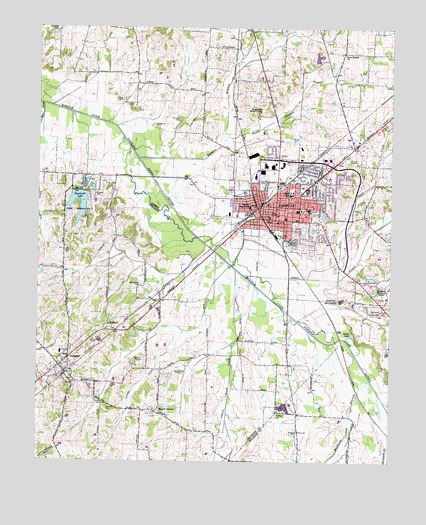
Humboldt, TN USGS Topographic Map
Click on map above to begin viewing in our Map Viewer.

This topographic map contains these locations and features:
Feature Name Type Latitude Longitude GNIS ID View Map
AntiochPopulated PlaceN35.7898°W88.9742°1275782View Map
Antioch ChurchChurchN35.7898°W88.9751°1317638View Map
Antioch School (historical)SchoolN35.7906°W88.9728°1317639View Map
AvondalePopulated PlaceN35.8412°W88.8970°1647623View Map
Bailey ParkParkN35.8223°W88.9062°1276116View Map
Barnett BranchStreamN35.8370°W88.9642°1276364View Map
Beech CreekStreamN35.8053°W88.9298°1276808View Map
Bethel ChurchChurchN35.7640°W88.9148°1277123View Map
Boikin CemeteryCemeteryN35.7792°W88.9626°1277883View Map
Bradford CemeteryCemeteryN35.8523°W88.9667°1278162View Map
City of HumboldtCivilN35.8255°W88.9045°2404741View Map
Collinsworth CemeteryCemeteryN35.8006°W88.9637°1281018View Map
Commissioner District 12CivilN35.7603°W88.9638°2464354View Map
Commissioner District 4CivilN35.8111°W88.9158°2464035View Map
Commissioner District 5CivilN35.8333°W88.9200°2464443View Map
District 2 (historical)CivilN35.7667°W88.9584°1652418View Map
District 3 (historical)CivilN35.8501°W88.8834°1310241View Map
Duffy BranchStreamN35.8423°W88.9337°1283078View Map
Dukes LakeReservoirN35.7868°W88.8886°1283120View Map
Enterprise School (historical)SchoolN35.8448°W88.9428°1322098View Map
GadsdenPopulated PlaceN35.7759°W88.9901°1285062View Map
Gadsden Division (historical)CensusN35.7801°W88.9815°1648662View Map
Gadsden Elementary SchoolSchoolN35.7815°W88.9917°1309865View Map
Gadsden First Baptist ChurchChurchN35.7798°W88.9892°1643426View Map
Gadsden Post OfficePost OfficeN35.7807°W88.9884°1650125View Map
Gadsden United Methodist ChurchChurchN35.7756°W88.9937°2724892View Map
Gadsden Volunteer Fire DepartmentBuildingN35.7818°W88.9916°2653943View Map
Gregory CemeteryCemeteryN35.7587°W88.9078°1286239View Map
HumboldtPopulated PlaceN35.8198°W88.9159°1288697View Map
Humboldt Area Rescue Squad and EMSBuildingN35.8361°W88.8943°2697411View Map
Humboldt City HallBuildingN35.8198°W88.9190°1322128View Map
Humboldt Country ClubLocaleN35.7934°W88.8781°1288698View Map
Humboldt DamDamN35.8277°W88.9850°1307161View Map
Humboldt Division (historical)CensusN35.8267°W88.9078°1648700View Map
Humboldt Fire Department Station 1BuildingN35.8198°W88.9192°2653764View Map
Humboldt Fire Department Station 2BuildingN35.8363°W88.9078°2653675View Map
Humboldt General HospitalHospitalN35.8157°W88.8953°2697327View Map
Humboldt High SchoolSchoolN35.8270°W88.9103°1322130View Map
Humboldt LakeReservoirN35.8189°W88.9864°1288699View Map
Humboldt Municipal AirportAirportN35.7981°W88.8771°1301368View Map
Humboldt Police DepartmentBuildingN35.8220°W88.9164°2765921View Map
Humboldt Post OfficePost OfficeN35.8212°W88.9163°1651858View Map
Humboldt Public LibraryBuildingN35.8190°W88.9153°1322131View Map
Humboldt Scout CampLocaleN35.8503°W88.9212°1288700View Map
Humphreys School (historical)SchoolN35.7792°W88.9445°1317650View Map
Jones Farm DamDamN35.8651°W88.9017°1302183View Map
Jones Farm LakeReservoirN35.8663°W88.9015°1302182View Map
Little Sugar CreekStreamN35.8028°W88.9042°1291681View Map
Main Street Elementary SchoolSchoolN35.8201°W88.9123°1322146View Map
Mason CemeteryCemeteryN35.7759°W88.9498°1292882View Map
Mason GrovePopulated PlaceN35.7645°W88.9581°1292886View Map
Matthews BranchStreamN35.7817°W88.8881°1303417View Map
McLeary CemeteryCemeteryN35.8478°W88.9501°1293404View Map
Moore CemeteryCemeteryN35.7587°W88.9076°1294266View Map
Motley CemeteryCemeteryN35.8537°W88.9703°1294525View Map
Motley School (historical)SchoolN35.8545°W88.9653°1322161View Map
Nesbitt CemeteryCemeteryN35.8267°W88.9798°1295398View Map
New ShilohPopulated PlaceN35.8681°W88.8920°1312583View Map
New Shiloh ChurchChurchN35.8670°W88.8915°1295648View Map
Newhouse CemeteryCemeteryN35.8467°W88.9587°1295689View Map
Oak Hill CemeteryCemeteryN35.7659°W88.9748°1296139View Map
Odd Fellow Female College (historical)SchoolN35.8201°W88.9123°1322188View Map
Phillips SchoolSchoolN35.8745°W88.9934°1297368View Map
Raines CemeteryCemeteryN35.7665°W88.9762°1298834View Map
Rose Hill CemeteryCemeteryN35.8128°W88.9092°1300077View Map
Roseman CemeteryCemeteryN35.7845°W88.9803°1300097View Map
Saint Marys HospitalHospitalN35.8226°W88.9045°1322209View Map
Sticall High SchoolSchoolN35.8231°W88.9248°1271378View Map
Stigall Elementary SchoolSchoolN35.8237°W88.9245°1322225View Map
Sugar CreekStreamN35.8037°W88.9267°1303893View Map
Town of GadsdenCivilN35.7769°W88.9861°2406535View Map
Warren DitchCanalN35.7673°W88.9676°1273833View Map
Warrens Grove School (historical)SchoolN35.8684°W88.8915°1322242View Map
WHMT-AM (Humboldt)TowerN35.8448°W88.9023°1639899View Map
WIRJ-AM (Humboldt)TowerN35.8145°W88.9142°1639894View Map
WZDQ-FM (Humboldt)TowerN35.8145°W88.9142°1640068View Map

Note: Coordinates in the location and feature list above are referenced to NAD83 datum.


Copyright (C) 2008-2025 Ryan Niemi / Sunset Dynamics ... All Rights Reserved