TopoQuest Logo
Do you find TopoQuest useful?
Help keep TopoQuest running and adding new maps/features by donating!
Bitcoin:  19c7KJd3qBynnjoSw5npx9KScwjBe4ifkT
Litecoin:  LXs6TkuXGGXo1vDsWCkWVdjQX94eUKd6ui
Home View Maps Find Maps Find Places Resources & Links


Alamo, Tennessee Topographic Map

USGS Map Title: Alamo, TN
USGS Map MRC: 35089G1
DRG (GeoTIFF) Download: o35089g1.tif


Neighboring USGS Topographic Map Quads:


  Friendship, TN  
35089H2
 

  Brazil, TN  
35089H1
 

  Trenton, TN  
35088H8
 

  Maury City, TN  
35089G2
 

  Alamo, TN  
35089G1
 

  Humboldt, TN  
35088G8
 

  Jones, TN  
35089F2
 

  Bells, TN  
35089F1
 

  Adair, TN  
35088F8


Map MRC Location:

N36°
W90°
N36°
W89°
H8 H7 H6 H5 H4 H3 H2 H1
G8 G7 G6 G5 G4 G3 G2 G1
F8 F7 F6 F5 F4 F3 F2 F1
E8 E7 E6 E5 E4 E3 E2 E1
D8 D7 D6 D5 D4 D3 D2 D1
C8 C7 C6 C5 C4 C3 C2 C1
B8 B7 B6 B5 B4 B3 B2 B1
A8 A7 A6 A5 A4 A3 A2 A1
N35°
W90°
N35°
W89°

Alamo, TN USGS 1:24K Topographic Map Preview:
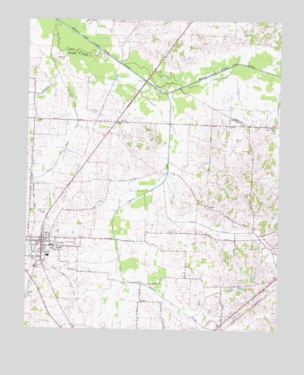
Alamo, TN USGS Topographic Map
Click on map above to begin viewing in our Map Viewer.

This topographic map contains these locations and features:
Feature Name Type Latitude Longitude GNIS ID View Map
AlamoPopulated PlaceN35.7848°W89.1173°1304782View Map
Alamo Division (historical)CensusN35.7931°W89.1231°1648659View Map
Alamo First Baptist ChurchChurchN35.7862°W89.1159°1643420View Map
Alamo Police DepartmentBuildingN35.7850°W89.1178°2765912View Map
Alamo Post OfficePost OfficeN35.7836°W89.1160°1650117View Map
Alamo Volunteer Fire DepartmentBuildingN35.7836°W89.1150°2653944View Map
Averys CemeteryCemeteryN35.8309°W89.0648°1647227View Map
Bailey School (historical)SchoolN35.8690°W89.0334°1322043View Map
Bear CreekStreamN35.8465°W89.0001°1276592View Map
Brookdale School (historical)SchoolN35.7512°W89.0962°1317642View Map
Buck CreekStreamN35.8690°W89.1131°1278809View Map
CenterLocaleN35.7995°W89.0348°1280118View Map
Center ChurchChurchN35.8003°W89.0365°1317643View Map
Central SchoolSchoolN35.7751°W89.1206°1305830View Map
Commissioner District 6CivilN35.8009°W89.0239°2464521View Map
Commissioner District 7CivilN35.7865°W89.1247°2464598View Map
Commissioner District 8CivilN35.7836°W89.0891°2464664View Map
Consolidated SchoolSchoolN35.7837°W89.1117°1306075View Map
Coxs ChapelChurchN35.8223°W89.0148°1306160View Map
CoxvillePopulated PlaceN35.8331°W89.0256°1314901View Map
Crockett County CourthouseBuildingN35.7851°W89.1170°1643423View Map
CypressPopulated PlaceN35.7612°W89.0681°1314926View Map
Cypress CreekStreamN35.8456°W89.0562°1281931View Map
District 3 (historical)CivilN35.7834°W89.0334°1310243View Map
District 4 (historical)CivilN35.8737°W89.0431°1310194View Map
District 4 (historical)CivilN35.8167°W89.0334°1310244View Map
District 6 (historical)CivilN35.7834°W89.1223°1310246View Map
District 7 (historical)CivilN35.8334°W89.0834°1310247View Map
Emison School (historical)SchoolN35.7545°W89.0567°1317647View Map
Epperson CreekStreamN35.8534°W89.1103°1283832View Map
Graham SchoolSchoolN35.7656°W89.0067°1285809View Map
Hopewell School (historical)SchoolN35.7865°W89.0401°1317648View Map
Horns BluffSummitN35.8587°W89.1087°1288376View Map
Liberty HallPopulated PlaceN35.7681°W89.0362°1650898View Map
Marlow CemeteryCemeteryN35.7656°W89.0370°1647229View Map
Mound FieldFlatN35.8606°W89.0945°1294539View Map
Mount Olive ChurchChurchN35.7895°W89.0545°1294705View Map
NancePopulated PlaceN35.8348°W89.1209°1315574View Map
Oakview Memorial ParkParkN35.7523°W89.1112°1296204View Map
Porters GrovePopulated PlaceN35.8326°W89.0023°1310839View Map
Porters Grove ChurchChurchN35.8317°W89.0028°1298278View Map
Porters Grove School (historical)SchoolN35.8323°W89.0031°1317654View Map
QuincyPopulated PlaceN35.8340°W89.0812°1315779View Map
Quincy CemeteryCemeteryN35.8378°W89.0901°1298764View Map
Salem ChurchChurchN35.8048°W89.0140°1300557View Map
Sand CreekStreamN35.8095°W89.0573°1300659View Map
Schoolhouse CreekStreamN35.8490°W89.0459°1300887View Map
Town of AlamoCivilN35.7832°W89.1165°2405126View Map
Vance School (historical)SchoolN35.8342°W89.1212°1317656View Map
WCTA-AM (Alamo)TowerN35.7998°W89.1223°1639892View Map
Young CemeteryCemeteryN35.7667°W89.0153°1275321View Map

Note: Coordinates in the location and feature list above are referenced to NAD83 datum.


Copyright (C) 2008-2024 Ryan Niemi / Sunset Dynamics ... All Rights Reserved