TopoQuest Logo
Do you find TopoQuest useful?
Help keep TopoQuest running and adding new maps/features by donating!
Bitcoin:  19c7KJd3qBynnjoSw5npx9KScwjBe4ifkT
Litecoin:  LXs6TkuXGGXo1vDsWCkWVdjQX94eUKd6ui
Home View Maps Find Maps Find Places Resources & Links


Hunters, Georgia Topographic Map

USGS Map Title: Hunters, GA
USGS Map MRC: 32081F5
DRG (GeoTIFF) Download: o32081f5.tif


Neighboring USGS Topographic Map Quads:


  Sylvania North, GA  
32081G6
 

  Jacksonboro Bridge, GA  
32081G5
 

  Brier Creek Landing, GA  
32081G4
 

  Sylvania South, GA  
32081F6
 

  Hunters, GA  
32081F5
 

  Blue Springs Landing, GA  
32081F4
 

  Dover, GA  
32081E6
 

  Oliver, GA  
32081E5
 

  Kildare, GA  
32081E4


Map MRC Location:

N33°
W82°
N33°
W81°
H8 H7 H6 H5 H4 H3 H2 H1
G8 G7 G6 G5 G4 G3 G2 G1
F8 F7 F6 F5 F4 F3 F2 F1
E8 E7 E6 E5 E4 E3 E2 E1
D8 D7 D6 D5 D4 D3 D2 D1
C8 C7 C6 C5 C4 C3 C2 C1
B8 B7 B6 B5 B4 B3 B2 B1
A8 A7 A6 A5 A4 A3 A2 A1
N32°
W82°
N32°
W81°

Hunters, GA USGS 1:24K Topographic Map Preview:
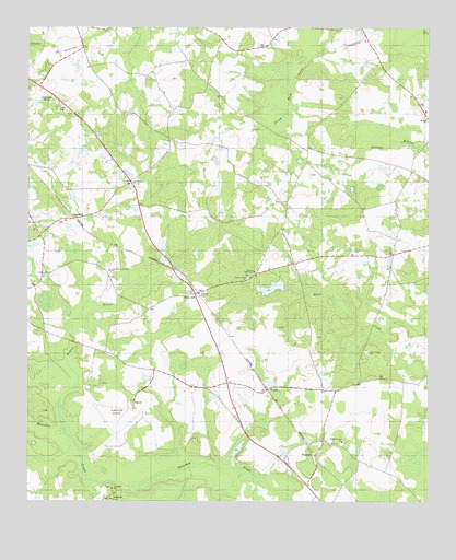
Hunters, GA USGS Topographic Map
Click on map above to begin viewing in our Map Viewer.

This topographic map contains these locations and features:
Feature Name Type Latitude Longitude GNIS ID View Map
Black Creek CemeteryCemeteryN32.6646°W81.5193°350153View Map
Black Creek CemeteryCemeteryN32.6843°W81.5562°350154View Map
Black Creek ChurchChurchN32.6646°W81.5184°354747View Map
Black Creek ChurchChurchN32.6843°W81.5568°354748View Map
CaptoloPopulated PlaceN32.6254°W81.5971°312331View Map
Evans School (historical)SchoolN32.6854°W81.6201°334893View Map
FarmdalePopulated PlaceN32.6996°W81.6101°331697View Map
Green HillPopulated PlaceN32.7096°W81.5929°350173View Map
Green Hill ChurchChurchN32.7088°W81.5932°356097View Map
Green Hill School (historical)SchoolN32.7102°W81.5937°334896View Map
Grist Mill PondReservoirN32.6389°W81.5592°337220View Map
Grist Mill Pond DamDamN32.6368°W81.5598°337219View Map
HuntersPopulated PlaceN32.6546°W81.5504°332043View Map
Jackson ChurchChurchN32.7263°W81.5004°316006View Map
Jackson School (historical)SchoolN32.7260°W81.5004°334901View Map
Kimberly-Clark LakeReservoirN32.6815°W81.5488°337218View Map
Kimberly-Clark Lake DamDamN32.6818°W81.5448°337217View Map
Landings East Sylvania AirportAirportN32.7441°W81.6133°351920View Map
Middle Baptist AssemblyChurchN32.7282°W81.5009°350179View Map
Middle Ground CemeteryCemeteryN32.6404°W81.5259°350180View Map
Middle Ground ChurchChurchN32.6407°W81.5265°318077View Map
Middle Ground School (historical)SchoolN32.6399°W81.5268°334904View Map
MiddlegroundPopulated PlaceN32.6413°W81.5326°350181View Map
New Robbins Branch ChurchChurchN32.6860°W81.5993°319526View Map
Pine Grove School (historical)SchoolN32.6596°W81.5854°334906View Map
Plantation AirparkAirportN32.6496°W81.5925°351919View Map
Red Bluff ChurchChurchN32.6285°W81.5982°321364View Map
Robbins BranchStreamN32.6441°W81.6129°321666View Map
Screven County Fire Department Station 8BuildingN32.7120°W81.5054°2603848View Map
SheppardsPopulated PlaceN32.6374°W81.5351°333029View Map
Sylvania Army Air Field (historical)MilitaryN32.6458°W81.5972°1987107View Map
Sylvania DivisionCivilN32.7484°W81.6024°1936571View Map
Weaver TabernacleChurchN32.6857°W81.5543°324952View Map
White HillPopulated PlaceN32.6799°W81.5732°326589View Map
WSYL-AM (Sylvania)TowerN32.7310°W81.6176°352562View Map

Note: Coordinates in the location and feature list above are referenced to NAD83 datum.


Copyright (C) 2008-2025 Ryan Niemi / Sunset Dynamics ... All Rights Reserved