TopoQuest Logo
Do you find TopoQuest useful?
Help keep TopoQuest running and adding new maps/features by donating!
Bitcoin:  19c7KJd3qBynnjoSw5npx9KScwjBe4ifkT
Litecoin:  LXs6TkuXGGXo1vDsWCkWVdjQX94eUKd6ui
Home View Maps Find Maps Find Places Resources & Links


Oliver, Georgia Topographic Map

USGS Map Title: Oliver, GA
USGS Map MRC: 32081E5
DRG (GeoTIFF) Download: o32081e5.tif


Neighboring USGS Topographic Map Quads:


  Sylvania South, GA  
32081F6
 

  Hunters, GA  
32081F5
 

  Blue Springs Landing, GA  
32081F4
 

  Dover, GA  
32081E6
 

  Oliver, GA  
32081E5
 

  Kildare, GA  
32081E4
 

  Brooklet, GA  
32081D6
 

  Leefield, GA  
32081D5
 

  Egypt, GA  
32081D4


Map MRC Location:

N33°
W82°
N33°
W81°
H8 H7 H6 H5 H4 H3 H2 H1
G8 G7 G6 G5 G4 G3 G2 G1
F8 F7 F6 F5 F4 F3 F2 F1
E8 E7 E6 E5 E4 E3 E2 E1
D8 D7 D6 D5 D4 D3 D2 D1
C8 C7 C6 C5 C4 C3 C2 C1
B8 B7 B6 B5 B4 B3 B2 B1
A8 A7 A6 A5 A4 A3 A2 A1
N32°
W82°
N32°
W81°

Oliver, GA USGS 1:24K Topographic Map Preview:
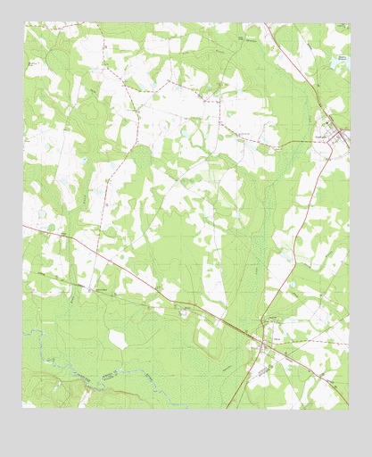
Oliver, GA USGS Topographic Map
Click on map above to begin viewing in our Map Viewer.

This topographic map contains these locations and features:
Feature Name Type Latitude Longitude GNIS ID View Map
Austin PondReservoirN32.5704°W81.5956°337222View Map
Austin Pond DamDamN32.5702°W81.5982°337221View Map
Blue Hole Mobile Home ParkPopulated PlaceN32.5327°W81.5330°2502499View Map
Brady BranchStreamN32.5149°W81.6065°311712View Map
Captolo School (historical)SchoolN32.6041°W81.5854°334889View Map
City of OliverCivilN32.5215°W81.5331°2404431View Map
Cyphus Pond ChurchChurchN32.6249°W81.5015°313230View Map
Durden PondReservoirN32.5102°W81.6098°341524View Map
Durden Pond DamDamN32.5102°W81.6098°341523View Map
Eureka Springs (historical)Populated PlaceN32.6071°W81.5171°334892View Map
Faith TempleChurchN32.5968°W81.5812°314067View Map
HalcyondalePopulated PlaceN32.5391°W81.5982°356138View Map
Huggins Bridge (historical)BridgeN32.5599°W81.5326°334900View Map
Huggins LakeReservoirN32.5516°W81.5274°337224View Map
Huggins Lake DamDamN32.5518°W81.5265°337223View Map
Jordan ChurchChurchN32.5391°W81.5737°316268View Map
Lee Memorial Church (historical)ChurchN32.5982°W81.5501°334902View Map
Long BranchStreamN32.6191°W81.5387°317310View Map
Meldrin MillpondReservoirN32.6117°W81.5010°318008View Map
Nancy BranchStreamN32.5516°W81.5329°319196View Map
Nelson BridgeBridgeN32.6202°W81.5396°319246View Map
NewingtonPopulated PlaceN32.5902°W81.5040°332497View Map
Newington Area Volunteer Fire DepartmentBuildingN32.5887°W81.5039°2603808View Map
Newington Baptist ChurchChurchN32.5899°W81.5062°2502341View Map
Newington DivisionCivilN32.5932°W81.5364°1936431View Map
Newington Police DepartmentBuildingN32.5887°W81.5039°2733907View Map
Newington Post OfficePost OfficeN32.5896°W81.5049°2502488View Map
Newton PondReservoirN32.5851°W81.5372°341488View Map
Newton Pond DamDamN32.5852°W81.5348°341487View Map
Ogeechee Branch ChurchChurchN32.5885°W81.5426°319913View Map
OliverPopulated PlaceN32.5216°W81.5332°332571View Map
Oliver Police DepartmentBuildingN32.5217°W81.5322°2733618View Map
Saint Johns ChurchChurchN32.5288°W81.5282°322123View Map
StalcoPopulated PlaceN32.5335°W81.5587°333109View Map
Town of NewingtonCivilN32.5888°W81.5063°2406986View Map
Union CemeteryCemeteryN32.6049°W81.5484°350199View Map
Union ChurchChurchN32.6049°W81.5482°324523View Map
Williams ChapelChurchN32.5555°W81.6101°325343View Map

Note: Coordinates in the location and feature list above are referenced to NAD83 datum.


Copyright (C) 2008-2025 Ryan Niemi / Sunset Dynamics ... All Rights Reserved