TopoQuest Logo
Do you find TopoQuest useful?
Help keep TopoQuest running and adding new maps/features by donating!
Bitcoin:  19c7KJd3qBynnjoSw5npx9KScwjBe4ifkT
Litecoin:  LXs6TkuXGGXo1vDsWCkWVdjQX94eUKd6ui
Home View Maps Find Maps Find Places Resources & Links


Sylvania South, Georgia Topographic Map

USGS Map Title: Sylvania South, GA
USGS Map MRC: 32081F6
DRG (GeoTIFF) Download: o32081f6.tif


Neighboring USGS Topographic Map Quads:


  Bay Branch, GA  
32081G7
 

  Sylvania North, GA  
32081G6
 

  Jacksonboro Bridge, GA  
32081G5
 

  Rocky Ford, GA  
32081F7
 

  Sylvania South, GA  
32081F6
 

  Hunters, GA  
32081F5
 

  Hopeulikit, GA  
32081E7
 

  Dover, GA  
32081E6
 

  Oliver, GA  
32081E5


Map MRC Location:

N33°
W82°
N33°
W81°
H8 H7 H6 H5 H4 H3 H2 H1
G8 G7 G6 G5 G4 G3 G2 G1
F8 F7 F6 F5 F4 F3 F2 F1
E8 E7 E6 E5 E4 E3 E2 E1
D8 D7 D6 D5 D4 D3 D2 D1
C8 C7 C6 C5 C4 C3 C2 C1
B8 B7 B6 B5 B4 B3 B2 B1
A8 A7 A6 A5 A4 A3 A2 A1
N32°
W82°
N32°
W81°

Sylvania South, GA USGS 1:24K Topographic Map Preview:
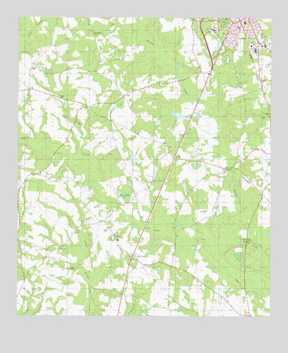
Sylvania South, GA USGS Topographic Map
Click on map above to begin viewing in our Map Viewer.

This topographic map contains these locations and features:
Feature Name Type Latitude Longitude GNIS ID View Map
AltmanPopulated PlaceN32.7257°W81.6304°350148View Map
Arnett SchoolSchoolN32.6571°W81.7001°354393View Map
Bennett LakeReservoirN32.7379°W81.6516°340339View Map
Bennett Lake DamDamN32.7368°W81.6532°340338View Map
Benton Grove ChurchChurchN32.6446°W81.7429°350150View Map
Bests BridgeBridgeN32.6868°W81.6451°311124View Map
Bethel African Methodist Episcopal ChurchChurchN32.7468°W81.6396°350151View Map
Bible ChurchChurchN32.7432°W81.6471°311284View Map
Blalock PondReservoirN32.6787°W81.6672°341290View Map
Blalock Pond DamDamN32.6768°W81.6665°341289View Map
Carter BranchStreamN32.7391°W81.7490°312365View Map
Central Middle SchoolSchoolN32.7446°W81.6534°312527View Map
City of SylvaniaCivilN32.7465°W81.6410°2405559View Map
Double HeadsPopulated PlaceN32.6493°W81.6934°350165View Map
Double Heads ChurchChurchN32.6504°W81.6915°355523View Map
Doughtry CemeteryCemeteryN32.7258°W81.7408°2093242View Map
First Baptist ChurchChurchN32.7488°W81.6362°350167View Map
Free Will ChurchChurchN32.7232°W81.6293°314365View Map
Freemam PondReservoirN32.7088°W81.6691°337216View Map
Freeman Pond DamDamN32.7085°W81.6665°337215View Map
Georgia State Patrol Troop F Post 21 SylvaniaBuildingN32.7490°W81.6521°2734171View Map
Gilgal School (historical)SchoolN32.6282°W81.6734°334894View Map
GoloidPopulated PlaceN32.6916°W81.6723°326304View Map
Goloid ChurchChurchN32.6960°W81.6762°350172View Map
Goloid School (historical)SchoolN32.6941°W81.6748°334895View Map
Great Bethel African Methodist Episcopal ChurchChurchN32.7467°W81.6392°2502271View Map
Harwell School (historical)SchoolN32.7168°W81.7298°334897View Map
Hen Coop BranchStreamN32.6846°W81.7134°315317View Map
Howard CemeteryCemeteryN32.6688°W81.6590°315752View Map
Lee PondLakeN32.6754°W81.6971°316740View Map
McCall BridgeBridgeN32.6560°W81.6368°317844View Map
Memorial ChurchChurchN32.7460°W81.6407°318017View Map
Miller PondReservoirN32.6911°W81.6927°337214View Map
Miller Pond DamDamN32.6885°W81.6915°337213View Map
Mount Pleasant CemeteryCemeteryN32.7432°W81.7126°318821View Map
Nelson PondReservoirN32.6939°W81.6617°341288View Map
Nelson Pond DamDamN32.6935°W81.6598°341287View Map
Ogeechee ChurchChurchN32.6604°W81.7209°319915View Map
Robinson Pond DamDamN32.6252°W81.6698°341277View Map
Rocky Ford DivisionCivilN32.6568°W81.7417°1936508View Map
Saint Paul Baptist ChurchChurchN32.7463°W81.6384°350188View Map
Screven County Elementary SchoolSchoolN32.7413°W81.6558°2453140View Map
Screven County Fire Department Station 2BuildingN32.6668°W81.7049°2604831View Map
Screven County High SchoolSchoolN32.7376°W81.6337°350192View Map
South Fork Ogeechee CreekStreamN32.6566°W81.6434°323246View Map
Springhead CemeteryCemeteryN32.6446°W81.7209°323471View Map
Springhead ChurchChurchN32.6529°W81.7296°323473View Map
Sylvania CemeteryCemeteryN32.7468°W81.6373°350195View Map
Sylvania Elementary SchoolSchoolN32.7482°W81.6382°350197View Map
Thompson CemeteryCemeteryN32.7099°W81.6257°324106View Map
Zeigler Cemetery ThreeCemeteryN32.7168°W81.7293°325657View Map

Note: Coordinates in the location and feature list above are referenced to NAD83 datum.


Copyright (C) 2008-2025 Ryan Niemi / Sunset Dynamics ... All Rights Reserved