TopoQuest Logo
Do you find TopoQuest useful?
Help keep TopoQuest running and adding new maps/features by donating!
Bitcoin:  19c7KJd3qBynnjoSw5npx9KScwjBe4ifkT
Litecoin:  LXs6TkuXGGXo1vDsWCkWVdjQX94eUKd6ui
Home View Maps Find Maps Find Places Resources & Links


Bainbridge, Ohio Topographic Map

USGS Map Title: Bainbridge, OH
USGS Map MRC: 39083B3
DRG (GeoTIFF) Download: o39083b3.tif


Neighboring USGS Topographic Map Quads:


  Greenfield, OH  
39083C4
 

  South Salem, OH  
39083C3
 

  Bourneville, OH  
39083C2
 

  Rainsboro, OH  
39083B4
 

  Bainbridge, OH  
39083B3
 

  Morgantown, OH  
39083B2
 

  Sinking Spring, OH  
39083A4
 

  Byington, OH  
39083A3
 

  Latham, OH  
39083A2


Map MRC Location:

N40°
W84°
N40°
W83°
H8 H7 H6 H5 H4 H3 H2 H1
G8 G7 G6 G5 G4 G3 G2 G1
F8 F7 F6 F5 F4 F3 F2 F1
E8 E7 E6 E5 E4 E3 E2 E1
D8 D7 D6 D5 D4 D3 D2 D1
C8 C7 C6 C5 C4 C3 C2 C1
B8 B7 B6 B5 B4 B3 B2 B1
A8 A7 A6 A5 A4 A3 A2 A1
N39°
W84°
N39°
W83°

Bainbridge, OH USGS 1:24K Topographic Map Preview:
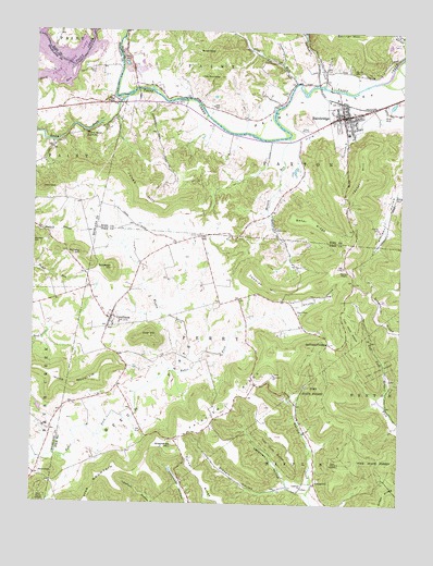
Bainbridge, OH USGS Topographic Map
Click on map above to begin viewing in our Map Viewer.

This topographic map contains these locations and features:
Feature Name Type Latitude Longitude GNIS ID View Map
BainbridgePopulated PlaceN39.2276°W83.2705°1048477View Map
Bainbridge CemeteryCemeteryN39.2245°W83.2719°1963436View Map
Bainbridge Church of ChristChurchN39.2245°W83.2694°1962857View Map
Bainbridge Elementary SchoolSchoolN39.2231°W83.2685°1050027View Map
Bainbridge Fire DepartmentBuildingN39.2301°W83.2718°2549645View Map
Bainbridge Post OfficePost OfficeN39.2278°W83.2707°2056625View Map
Bainbridge Presbyterian ChurchChurchN39.2292°W83.2685°1962858View Map
Bainbridge United Methodist ChurchChurchN39.2270°W83.2680°1962859View Map
Baker RidgeRidgeN39.2001°W83.2813°1037587View Map
Beech FlatsFlatN39.1712°W83.3191°1037785View Map
Beech Flats ChurchChurchN39.1753°W83.2846°1037789View Map
Benner CemeteryCemeteryN39.2400°W83.2668°1037852View Map
Benner School (historical)SchoolN39.1317°W83.2552°1055168View Map
Buckskin CreekStreamN39.2362°W83.2769°1038488View Map
Cameron HillSummitN39.1859°W83.3005°1048574View Map
Cameron School (historical)SchoolN39.1784°W83.3105°1055172View Map
Core HillSummitN39.1692°W83.3346°1039370View Map
Cove RunStreamN39.2365°W83.2871°1039411View Map
CynthianaPopulated PlaceN39.1737°W83.3485°1061013View Map
Cynthiana CemeteryCemeteryN39.1751°W83.3466°1963399View Map
Cynthiana Census Designated PlaceCensusN39.1736°W83.3485°2628880View Map
Cynthiana Post OfficePost OfficeN39.1737°W83.3491°2042469View Map
Fairview CemeteryCemeteryN39.1595°W83.2924°1963402View Map
Fairview ChurchChurchN39.1592°W83.2924°1040348View Map
Fairview RidgeRidgeN39.1509°W83.3099°1040364View Map
Fairview School (historical)SchoolN39.1478°W83.3127°1055179View Map
Garner CemeteryCemeteryN39.1978°W83.2574°1040783View Map
Haas AirportAirportN39.2247°W83.3156°1082478View Map
Housemantown School (historical)SchoolN39.2278°W83.3366°1053645View Map
Hulitt CemeteryCemeteryN39.2395°W83.3546°1041863View Map
Hulitt School (historical)SchoolN39.2317°W83.3630°1053180View Map
Irons MountainSummitN39.1590°W83.3674°1041998View Map
Jackson School (historical)SchoolN39.1395°W83.3702°1053181View Map
Jester HillSummitN39.2117°W83.2630°1042095View Map
Jones CemeteryCemeteryN39.1962°W83.3180°1042135View Map
Jones HillSummitN39.2095°W83.3402°1048877View Map
LapperellPopulated PlaceN39.1303°W83.2780°1064971View Map
Lapperell CemeteryCemeteryN39.1295°W83.2824°1963410View Map
Lapperell HollowValleyN39.1317°W83.2880°1042421View Map
Lapperell Post Office (historical)Post OfficeN39.1306°W83.2777°2042465View Map
Lapperell United Brethren ChurchChurchN39.1292°W83.2824°1042420View Map
Little RoundtopSummitN39.2378°W83.3135°1042686View Map
Massie RunStreamN39.2220°W83.2888°1061148View Map
McNary HillSummitN39.1912°W83.3591°1063440View Map
Muddy ForkStreamN39.1609°W83.3280°1043714View Map
Pake CemeteryCemeteryN39.1978°W83.2930°1044283View Map
Paxton Township Area Life SquadBuildingN39.2257°W83.2710°2550917View Map
Pickett Run FarmLocaleN39.1819°W83.3692°2724676View Map
Pine Top School (historical)SchoolN39.1867°W83.2680°1055214View Map
Pinetop ChapelChurchN39.1867°W83.2680°1044476View Map
Plum RunStreamN39.2409°W83.3613°1066901View Map
Rocky ForkStreamN39.2323°W83.3444°1045134View Map
RoundtopSummitN39.1331°W83.3674°1045224View Map
RoundtopSummitN39.2078°W83.3719°1045225View Map
RoundtopSummitN39.2448°W83.3152°1045226View Map
Shepherds MountainSummitN39.1403°W83.3269°1066954View Map
Spellman CrossingPopulated PlaceN39.1676°W83.2741°1063029View Map
Spring Valley FarmsLocaleN39.1786°W83.3608°2724665View Map
Star MountainSummitN39.1334°W83.3471°1060815View Map
Stewart HollowValleyN39.1292°W83.2902°1046689View Map
Sylvester HillSummitN39.1870°W83.3485°1046927View Map
The PointPopulated PlaceN39.2315°W83.3480°1061216View Map
The Seven CavesLocaleN39.2223°W83.3574°1058071View Map
Tong Hollow School (historical)SchoolN39.2490°W83.2521°1053647View Map
Township of PaxtonCivilN39.2234°W83.2578°1086902View Map
Township of PerryCivilN39.1627°W83.3200°1086816View Map
Valley Vista Airport (historical)AirportN39.2376°W83.2607°1082479View Map
Valley Vista Golf CourseLocaleN39.2473°W83.2524°1050028View Map
Village of BainbridgeCivilN39.2265°W83.2696°2398017View Map
West School (historical)SchoolN39.1376°W83.3502°1055230View Map
Whiskey HollowValleyN39.1776°W83.2832°1047865View Map

Note: Coordinates in the location and feature list above are referenced to NAD83 datum.


Copyright (C) 2008-2025 Ryan Niemi / Sunset Dynamics ... All Rights Reserved