TopoQuest Logo
Do you find TopoQuest useful?
Help keep TopoQuest running and adding new maps/features by donating!
Bitcoin:  19c7KJd3qBynnjoSw5npx9KScwjBe4ifkT
Litecoin:  LXs6TkuXGGXo1vDsWCkWVdjQX94eUKd6ui
Home View Maps Find Maps Find Places Resources & Links


Rainsboro, Ohio Topographic Map

USGS Map Title: Rainsboro, OH
USGS Map MRC: 39083B4
DRG (GeoTIFF) Download: o39083b4.tif


Neighboring USGS Topographic Map Quads:


  Leesburg, OH  
39083C5
 

  Greenfield, OH  
39083C4
 

  South Salem, OH  
39083C3
 

  Hillsboro, OH  
39083B5
 

  Rainsboro, OH  
39083B4
 

  Bainbridge, OH  
39083B3
 

  Belfast, OH  
39083A5
 

  Sinking Spring, OH  
39083A4
 

  Byington, OH  
39083A3


Map MRC Location:

N40°
W84°
N40°
W83°
H8 H7 H6 H5 H4 H3 H2 H1
G8 G7 G6 G5 G4 G3 G2 G1
F8 F7 F6 F5 F4 F3 F2 F1
E8 E7 E6 E5 E4 E3 E2 E1
D8 D7 D6 D5 D4 D3 D2 D1
C8 C7 C6 C5 C4 C3 C2 C1
B8 B7 B6 B5 B4 B3 B2 B1
A8 A7 A6 A5 A4 A3 A2 A1
N39°
W84°
N39°
W83°

Rainsboro, OH USGS 1:24K Topographic Map Preview:
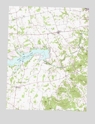
Rainsboro, OH USGS Topographic Map
Click on map above to begin viewing in our Map Viewer.

This topographic map contains these locations and features:
Feature Name Type Latitude Longitude GNIS ID View Map
Babingtons Trailer ParkPopulated PlaceN39.1778°W83.4536°2630633View Map
Barrett HillSummitN39.1931°W83.3760°1048486View Map
Barrett School (historical)SchoolN39.2451°W83.4996°1053145View Map
Barretts MillsPopulated PlaceN39.2026°W83.3871°1064382View Map
Barretts Mills Post Office (historical)Post OfficeN39.2026°W83.3874°2009666View Map
Beaver MillPopulated PlaceN39.1773°W83.4141°1037762View Map
Beaver School (historical)SchoolN39.2098°W83.4607°1053147View Map
Beavers CemeteryCemeteryN39.1967°W83.4263°1037774View Map
Blinco BranchStreamN39.2006°W83.4596°1038113View Map
Boyd CemeteryCemeteryN39.2009°W83.3846°1038238View Map
Brown HillSummitN39.1473°W83.4163°1038373View Map
Brushy KnobSummitN39.1270°W83.4321°1038437View Map
Butters CemeteryCemeteryN39.1389°W83.4363°1038581View Map
CarmelPopulated PlaceN39.1670°W83.4082°1060925View Map
Carmel CemeteryCemeteryN39.1645°W83.4077°1806543View Map
Carmel Church of GodChurchN39.1640°W83.4071°1073243View Map
Carmel Post Office (historical)Post OfficeN39.1667°W83.4082°2009673View Map
Christian Union CemeteryCemeteryN39.1531°W83.4863°1806545View Map
Churn CreekStreamN39.1984°W83.4874°1066649View Map
Coon CrossingPopulated PlaceN39.1559°W83.3919°1062710View Map
Country Home Trailer ParkPopulated PlaceN39.2122°W83.4394°2630634View Map
Curp CemeteryCemeteryN39.1542°W83.4182°1039543View Map
Dick CemeteryCemeteryN39.1539°W83.4746°1039698View Map
East Shore MarinaLocaleN39.1870°W83.4480°1962926View Map
Factory BranchStreamN39.2015°W83.3869°1040297View Map
Fall Creek ChurchChurchN39.2376°W83.4766°1040371View Map
Fort Hill Youth CampLocaleN39.1262°W83.3996°1040582View Map
Franklin BranchStreamN39.1787°W83.4260°1066719View Map
Friends CemeteryCemeteryN39.2295°W83.4632°1040685View Map
Hartman CemeteryCemeteryN39.2245°W83.3996°1041377View Map
Head CemeteryCemeteryN39.1742°W83.3913°1041435View Map
Heads BranchStreamN39.1915°W83.3988°1041438View Map
Heads HillSummitN39.1792°W83.3871°1041439View Map
Henrys Trailer CourtPopulated PlaceN39.1964°W83.4331°2630638View Map
Hickory Hills LakeReservoirN39.1742°W83.3945°1078149View Map
Hickory Hills Lake DamDamN39.1867°W83.3966°1078148View Map
Hicksite Quaker CemeteryCemeteryN39.2356°W83.4885°1806555View Map
Highland HolidayPopulated PlaceN39.1975°W83.4695°2633225View Map
Highland Holiday Census Designated PlaceCensusN39.1949°W83.4703°2633224View Map
Jericho School (historical)SchoolN39.1806°W83.4044°1053182View Map
Kearns School (historical)SchoolN39.2426°W83.4499°1053184View Map
Lighthouse Trailer ParkPopulated PlaceN39.1931°W83.4344°2630636View Map
Long Lick HillRidgeN39.1567°W83.4007°1061145View Map
MarshallPopulated PlaceN39.1520°W83.4849°1061475View Map
Marshall Church of ChristChurchN39.1520°W83.4885°1073253View Map
Marshall Elementary SchoolSchoolN39.1512°W83.4855°1055316View Map
Marshall Post Office (historical)Post OfficeN39.1515°W83.4846°2009709View Map
Marshall Township Volunteer Fire DepartmentBuildingN39.1522°W83.4844°2549594View Map
Marshall United Methodist ChurchChurchN39.1520°W83.4821°1073254View Map
McCoppin HillSummitN39.1642°W83.3971°1061151View Map
McCoppin MillPopulated PlaceN39.1826°W83.4385°1061152View Map
Methodist CemeteryCemeteryN39.1528°W83.4882°1806564View Map
Moore CemeteryCemeteryN39.1687°W83.4877°1043465View Map
Mustard FarmsLocaleN39.2194°W83.4303°2724727View Map
North BeachLocaleN39.1926°W83.4777°1043912View Map
Paint Number 2 SchoolSchoolN39.2187°W83.4224°1057907View Map
Pickett RunStreamN39.1973°W83.3907°1044424View Map
Plum RunStreamN39.1817°W83.4524°1066900View Map
Presbyterian CemeteryCemeteryN39.1512°W83.4810°1806576View Map
Pumill CemeteryCemeteryN39.1417°W83.4016°1044794View Map
Puncheon RunStreamN39.1928°W83.4094°1066911View Map
RainsboroPopulated PlaceN39.2201°W83.4221°1057943View Map
Rainsboro Post OfficePost OfficeN39.2195°W83.4221°2013527View Map
Redkey School (historical)SchoolN39.1695°W83.4519°1053202View Map
Roads CemeteryCemeteryN39.2012°W83.3977°1045076View Map
Rocky Fork LakeReservoirN39.1862°W83.4833°1045138View Map
Rocky Fork Lake DamDamN39.1845°W83.4396°1078147View Map
Rocky Fork PointPopulated PlaceN39.1914°W83.4913°2633223View Map
Rocky Fork Point Census Designated PlaceCensusN39.1878°W83.4901°2633222View Map
Rocky Fork State ParkParkN39.1865°W83.4724°1045139View Map
Seller's OrchardLocaleN39.1536°W83.4947°2516121View Map
Slate HillSummitN39.1342°W83.4394°1066966View Map
Slate Hill School (historical)SchoolN39.1317°W83.4482°1053210View Map
Smith BranchStreamN39.1703°W83.4885°1046358View Map
Snake Corners School (historical)SchoolN39.2467°W83.3971°1053211View Map
South BeachPopulated PlaceN39.1826°W83.4769°1063027View Map
South Beach MarinaLocaleN39.1828°W83.4788°1962928View Map
South Branch Trailer CourtPopulated PlaceN39.1733°W83.4711°2630641View Map
Spargur HillSummitN39.1737°W83.4035°1046516View Map
StringtownPopulated PlaceN39.2348°W83.4883°1065395View Map
Thunder Valley RanchLocaleN39.1356°W83.4303°2724732View Map
Township of MarshallCivilN39.1455°W83.4839°1086308View Map
Township of PaintCivilN39.2324°W83.4401°1086310View Map
Washburn HillRidgeN39.1378°W83.4255°1067039View Map
Washburn School (historical)SchoolN39.1265°W83.4080°1053222View Map
Westwood ChurchChurchN39.1706°W83.3994°1047837View Map
Zink CemeteryCemeteryN39.1362°W83.4449°1048243View Map

Note: Coordinates in the location and feature list above are referenced to NAD83 datum.


Copyright (C) 2008-2025 Ryan Niemi / Sunset Dynamics ... All Rights Reserved