TopoQuest Logo
Do you find TopoQuest useful?
Help keep TopoQuest running and adding new maps/features by donating!
Bitcoin:  19c7KJd3qBynnjoSw5npx9KScwjBe4ifkT
Litecoin:  LXs6TkuXGGXo1vDsWCkWVdjQX94eUKd6ui
Home View Maps Find Maps Find Places Resources & Links


Huntsdale, Missouri Topographic Map

USGS Map Title: Huntsdale, MO
USGS Map MRC: 38092H4
DRG (GeoTIFF) Download: o38092h4.tif


Neighboring USGS Topographic Map Quads:


  Hilldale, MO  
39092A5
 

  Sturgeon SW, MO  
39092A4
 

  Browns, MO  
39092A3
 

  Rocheport, MO  
38092H5
 

  Huntsdale, MO  
38092H4
 

  Columbia, MO  
38092H3
 

  Prairie Home, MO  
38092G5
 

  Jamestown, MO  
38092G4
 

  Ashland, MO  
38092G3


Map MRC Location:

N39°
W93°
N39°
W92°
H8 H7 H6 H5 H4 H3 H2 H1
G8 G7 G6 G5 G4 G3 G2 G1
F8 F7 F6 F5 F4 F3 F2 F1
E8 E7 E6 E5 E4 E3 E2 E1
D8 D7 D6 D5 D4 D3 D2 D1
C8 C7 C6 C5 C4 C3 C2 C1
B8 B7 B6 B5 B4 B3 B2 B1
A8 A7 A6 A5 A4 A3 A2 A1
N38°
W93°
N38°
W92°

Huntsdale, MO USGS 1:24K Topographic Map Preview:
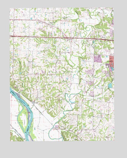
Huntsdale, MO USGS Topographic Map
Click on map above to begin viewing in our Map Viewer.

This topographic map contains these locations and features:
Feature Name Type Latitude Longitude GNIS ID View Map
Bear CreekStreamN38.9942°W92.3782°713801View Map
Black BranchStreamN38.9186°W92.4305°714284View Map
Boone County Fire Protection District Station 14BuildingN38.9133°W92.3994°2621392View Map
Boone County Fire Protection District Station 9BuildingN38.9817°W92.4413°2621400View Map
Broadway ChurchChurchN38.9553°W92.3774°714732View Map
Brushwood (historical)BuildingN38.9142°W92.4263°759337View Map
Brushwood LakeLakeN38.9112°W92.4256°714876View Map
Callahan CreekStreamN38.9809°W92.4102°715202View Map
Cedar LakeReservoirN38.9403°W92.4611°761532View Map
Cedar Lake Section 23 DamDamN38.9400°W92.4602°761531View Map
Columbia Fire Department Station 6BuildingN38.9346°W92.3838°2620569View Map
Conley CemeteryCemeteryN38.8886°W92.4360°716192View Map
County House BranchStreamN38.9303°W92.3827°716382View Map
Daniel (historical)BuildingN38.9000°W92.4419°759338View Map
Fairview CemeteryCemeteryN38.9359°W92.3801°2681354View Map
Fairview ChurchChurchN38.9361°W92.3805°717787View Map
Fairview Elementary SchoolSchoolN38.9445°W92.3817°717809View Map
Fairview LakeReservoirN38.9472°W92.3773°761624View Map
Fairview Lake DamDamN38.9467°W92.3769°761623View Map
Goodin BranchStreamN38.9278°W92.4016°718564View Map
Goodin CemeteryCemeteryN38.9407°W92.4025°718565View Map
Grocery BranchStreamN38.9053°W92.4752°718888View Map
Harmony CreekStreamN38.9667°W92.4113°719117View Map
Henderson BranchStreamN38.9564°W92.4141°719368View Map
Hickory Grove School (historical)SchoolN38.9595°W92.4721°759339View Map
Hinkson CreekStreamN38.9220°W92.4141°750340View Map
Hulen LakeReservoirN38.9426°W92.3770°719983View Map
Hulen Lake East DamDamN38.9400°W92.3752°761622View Map
Hulen Lake West DamDamN38.9400°W92.3769°761377View Map
Hunt LakeReservoirN38.9610°W92.4465°761540View Map
HuntsdalePopulated PlaceN38.9117°W92.4724°720025View Map
Huntsdale School (historical)SchoolN38.9139°W92.4710°759340View Map
Kennard Station (historical)BuildingN38.8875°W92.4446°736067View Map
Mary Paxton Keeley Elementary SchoolSchoolN38.9584°W92.3857°2570984View Map
McBainePopulated PlaceN38.8870°W92.4466°722026View Map
McBaine BendBendN38.8764°W92.4786°2118162View Map
McBaine School (historical)SchoolN38.8875°W92.4474°759341View Map
Merideth BranchStreamN38.9200°W92.4080°722237View Map
MidwayPopulated PlaceN38.9850°W92.4494°722296View Map
Midway BranchStreamN38.9903°W92.4174°722298View Map
Midway Heights Elementary SchoolSchoolN38.9870°W92.4632°722302View Map
Mill CreekStreamN38.9139°W92.4024°722334View Map
Morton BranchStreamN38.9392°W92.4866°722665View Map
Mount Celestial ChurchChurchN38.8764°W92.4199°722742View Map
Mount Nebo CemeteryCemeteryN38.9237°W92.4614°722791View Map
Petite Saline CreekStreamN38.8764°W92.4819°724263View Map
Rapp Lake DamDamN38.9334°W92.4319°762360View Map
Rocky Fork CreekStreamN38.9931°W92.3991°725511View Map
Sapp Lake DamDamN38.8917°W92.4019°762359View Map
Scotts BranchStreamN38.9345°W92.4005°726160View Map
Searcys BendBendN38.9042°W92.4758°2118161View Map
Smarr Lake DamDamN38.9600°W92.4452°761539View Map
Smithton Middle SchoolSchoolN38.9599°W92.3886°2570988View Map
Star School (historical)SchoolN38.8828°W92.4600°759342View Map
Strawn School (historical)SchoolN38.9636°W92.3988°727174View Map
Sugar BranchStreamN38.9453°W92.4246°727215View Map
Sugar Branch AirportAirportN38.9499°W92.4464°2679316View Map
Sugar Creek CemeteryCemeteryN38.9455°W92.4718°727236View Map
Tadpole IslandIslandN38.8973°W92.4821°727433View Map
Terrapin CreekStreamN38.9198°W92.4894°727537View Map
Town of HuntsdaleCivilN38.9115°W92.4722°2397004View Map
Town of McBaineCivilN38.8832°W92.4550°2396743View Map
Township of KatyCivilN38.9783°W92.4753°2045043View Map
TurnerPopulated PlaceN38.9175°W92.4002°718298View Map
Turner StationLocaleN38.9167°W92.4169°759343View Map
Union ChurchChurchN38.8784°W92.3830°727995View Map
Valley Spring School (historical)SchoolN38.9482°W92.4455°759344View Map
Valley Springs CemeteryCemeteryN38.9486°W92.4427°728103View Map
Vawter School (historical)SchoolN38.9118°W92.3940°759345View Map
Via School (historical)SchoolN38.9353°W92.3814°759360View Map
Whist LandingLocaleN38.8985°W92.4951°736046View Map

Note: Coordinates in the location and feature list above are referenced to NAD83 datum.


Copyright (C) 2008-2025 Ryan Niemi / Sunset Dynamics ... All Rights Reserved