TopoQuest Logo
Do you find TopoQuest useful?
Help keep TopoQuest running and adding new maps/features by donating!
Bitcoin:  19c7KJd3qBynnjoSw5npx9KScwjBe4ifkT
Litecoin:  LXs6TkuXGGXo1vDsWCkWVdjQX94eUKd6ui
Home View Maps Find Maps Find Places Resources & Links


Hurdland, Missouri Topographic Map

USGS Map Title: Hurdland, MO
USGS Map MRC: 40092B3
DRG (GeoTIFF) Download: o40092b3.tif


Neighboring USGS Topographic Map Quads:


  Willmathsville, MO  
40092C4
 

  Bible Grove, MO  
40092C3
 

  Greensburg, MO  
40092C2
 

  Brashear, MO  
40092B4
 

  Hurdland, MO  
40092B3
 

  Edina, MO  
40092B2
 

  La Plata, MO  
40092A4
 

  Locust Hill, MO  
40092A3
 

  Novelty, MO  
40092A2


Map MRC Location:

N41°
W93°
N41°
W92°
H8 H7 H6 H5 H4 H3 H2 H1
G8 G7 G6 G5 G4 G3 G2 G1
F8 F7 F6 F5 F4 F3 F2 F1
E8 E7 E6 E5 E4 E3 E2 E1
D8 D7 D6 D5 D4 D3 D2 D1
C8 C7 C6 C5 C4 C3 C2 C1
B8 B7 B6 B5 B4 B3 B2 B1
A8 A7 A6 A5 A4 A3 A2 A1
N40°
W93°
N40°
W92°

Hurdland, MO USGS 1:24K Topographic Map Preview:
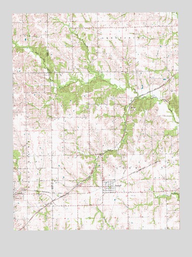
Hurdland, MO USGS Topographic Map
Click on map above to begin viewing in our Map Viewer.

This topographic map contains these locations and features:
Feature Name Type Latitude Longitude GNIS ID View Map
Baker School (historical)SchoolN40.2092°W92.2569°733079View Map
Black School (historical)SchoolN40.2411°W92.3219°733080View Map
Brashear CemeteryCemeteryN40.1439°W92.3741°714645View Map
City of HurdlandCivilN40.1489°W92.3034°2394455View Map
Colonial Knoll LakeReservoirN40.1500°W92.2552°762273View Map
Delaney School (historical)SchoolN40.2423°W92.2630°733078View Map
Fox School (historical)SchoolN40.1920°W92.3177°733081View Map
Hunziker Airport (historical)AirportN40.1359°W92.2979°758731View Map
HurdlandPopulated PlaceN40.1500°W92.3021°720028View Map
Hurdland Post OfficePost OfficeN40.1494°W92.3016°2783157View Map
Hurdland StationLocaleN40.1517°W92.3249°740420View Map
Hurdland Volunteer Fire DepartmentBuildingN40.1499°W92.3007°2621025View Map
International Order of Odd Fellows CemeteryCemeteryN40.1446°W92.2882°2777499View Map
James LakeReservoirN40.2467°W92.2969°760300View Map
James Lake DamDamN40.2467°W92.2969°760299View Map
KenwoodPopulated PlaceN40.1956°W92.2871°740981View Map
Liberty Grove School (historical)SchoolN40.1784°W92.2596°733082View Map
Long BranchStreamN40.2011°W92.2810°721500View Map
Nick BranchStreamN40.2142°W92.3113°723366View Map
Parsons LakeReservoirN40.1334°W92.2569°762275View Map
Parsons Lake DamDamN40.1334°W92.2569°762274View Map
PaultownPopulated PlaceN40.1606°W92.3649°733686View Map
Paultown CemeteryCemeteryN40.1609°W92.3560°724109View Map
Paultown School (historical)SchoolN40.1609°W92.3727°733684View Map
Pleasant Hill School (historical)SchoolN40.1392°W92.3527°733685View Map
Rock Creek Branch DamDamN40.1500°W92.2552°762272View Map
Rock Creek CemeteryCemeteryN40.1459°W92.2513°725450View Map
Rock Creek Church (historical)ChurchN40.1461°W92.2521°733084View Map
Rock Creek School (historical)SchoolN40.1467°W92.2552°733083View Map
Taylor LakeReservoirN40.1800°W92.3369°762271View Map
Taylor Lake DamDamN40.1800°W92.3369°762270View Map
Township of LyonCivilN40.1706°W92.2612°766853View Map

Note: Coordinates in the location and feature list above are referenced to NAD83 datum.


Copyright (C) 2008-2025 Ryan Niemi / Sunset Dynamics ... All Rights Reserved