TopoQuest Logo
Do you find TopoQuest useful?
Help keep TopoQuest running and adding new maps/features by donating!
Bitcoin:  19c7KJd3qBynnjoSw5npx9KScwjBe4ifkT
Litecoin:  LXs6TkuXGGXo1vDsWCkWVdjQX94eUKd6ui
Home View Maps Find Maps Find Places Resources & Links


Rougemont, North Carolina Topographic Map

USGS Map Title: Rougemont, NC
USGS Map MRC: 36078B8
DRG (GeoTIFF) Download: o36078b8.tif


Neighboring USGS Topographic Map Quads:


  Hurdle Mills, NC  
36079C1
 

  Timberlake, NC  
36078C8
 

  Moriah, NC  
36078C7
 

  Caldwell, NC  
36079B1
 

  Rougemont, NC  
36078B8
 

  Lake Michie, NC  
36078B7
 

  Hillsborough, NC  
36079A1
 

  Northwest Durham, NC  
36078A8
 

  Northeast Durham, NC  
36078A7


Map MRC Location:

N37°
W79°
N37°
W78°
H8 H7 H6 H5 H4 H3 H2 H1
G8 G7 G6 G5 G4 G3 G2 G1
F8 F7 F6 F5 F4 F3 F2 F1
E8 E7 E6 E5 E4 E3 E2 E1
D8 D7 D6 D5 D4 D3 D2 D1
C8 C7 C6 C5 C4 C3 C2 C1
B8 B7 B6 B5 B4 B3 B2 B1
A8 A7 A6 A5 A4 A3 A2 A1
N36°
W79°
N36°
W78°

Rougemont, NC USGS 1:24K Topographic Map Preview:
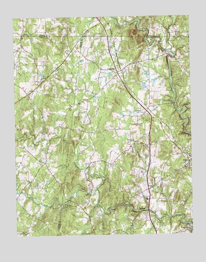
Rougemont, NC USGS Topographic Map
Click on map above to begin viewing in our Map Viewer.

This topographic map contains these locations and features:
Feature Name Type Latitude Longitude GNIS ID View Map
BahamaPopulated PlaceN36.1660°W78.8767°1018897View Map
Bahama Fire and Rescue Station 2BuildingN36.2034°W78.9164°2639494View Map
Bahama Post OfficePost OfficeN36.1641°W78.8785°2774086View Map
Bartons Mill (historical)LocaleN36.2465°W78.9195°1966748View Map
Blaylocks Store (historical)LocaleN36.2426°W78.9345°1966751View Map
Bollinger PondReservoirN36.2118°W78.9081°1000343View Map
Bollinger Pond DamDamN36.2118°W78.9081°1000344View Map
Buffalo CreekStreamN36.1704°W78.9553°982169View Map
Caldmont LakeReservoirN36.2168°W78.9781°1000360View Map
Caldmont Lake DamDamN36.2168°W78.9781°1000359View Map
Deep CreekStreamN36.2307°W78.8881°1023943View Map
Farlow Field (historical)AirportN36.1738°W78.8950°998044View Map
FieldstreamPopulated PlaceN36.1815°W78.9778°1002521View Map
Fox RunPopulated PlaceN36.1413°W78.9645°1020346View Map
George K Slocum Forestry CampLocaleN36.2013°W78.8881°1008003View Map
Hunkadora Post Office (historical)Post OfficeN36.1660°W78.8767°1955470View Map
Lipscomb Grove ChurchChurchN36.1268°W78.9922°988520View Map
Little River SchoolSchoolN36.1454°W78.9067°988758View Map
LyndoverLocaleN36.2363°W78.9272°1023515View Map
Mangum SchoolSchoolN36.1699°W78.8758°989273View Map
McFarland LakeReservoirN36.2151°W78.8981°1000351View Map
McFarland Lake DamDamN36.2151°W78.8981°1000352View Map
Moores Mill (historical)LocaleN36.2426°W78.9097°1966754View Map
Mountain CreekStreamN36.1351°W78.8903°990688View Map
New Bethel ChurchChurchN36.2151°W78.9806°990940View Map
North Carolina State University ForestForestN36.2013°W78.8881°1023514View Map
North Fork Little RiverStreamN36.1510°W78.9417°991225View Map
Orange FactoryPopulated PlaceN36.1274°W78.8756°1021751View Map
Quail RoostPopulated PlaceN36.1943°W78.9075°1022117View Map
Quail Roost Lake Dam Number ThreeDamN36.1951°W78.9114°1000313View Map
Quail Roost Lake Number OneReservoirN36.1935°W78.9231°1000309View Map
Quail Roost Lake Number One DamDamN36.1935°W78.9231°1000308View Map
Quail Roost Lake Number ThreeReservoirN36.1951°W78.9114°1000314View Map
Quail Roost Lake Number TwoReservoirN36.1951°W78.9164°1000315View Map
Quail Roost Lake Number Two DamDamN36.1951°W78.9164°1000316View Map
Red MountainSummitN36.2404°W78.9150°1022196View Map
Red MountainPopulated PlaceN36.2251°W78.9036°1023516View Map
Red Mountain ChurchChurchN36.2254°W78.8986°993126View Map
RougemontPopulated PlaceN36.2185°W78.9264°1022403View Map
Rougemont Census Designated PlaceCensusN36.2208°W78.9206°2628653View Map
Rougemont Post OfficePost OfficeN36.2100°W78.9215°2773836View Map
Rougemont QuarryMineN36.2233°W78.9519°2703899View Map
South Fork Little RiverStreamN36.1510°W78.9417°995155View Map
Union Grove ChurchChurchN36.1757°W78.9050°996492View Map

Note: Coordinates in the location and feature list above are referenced to NAD83 datum.


Copyright (C) 2008-2024 Ryan Niemi / Sunset Dynamics ... All Rights Reserved