TopoQuest Logo
Do you find TopoQuest useful?
Help keep TopoQuest running and adding new maps/features by donating!
Bitcoin:  19c7KJd3qBynnjoSw5npx9KScwjBe4ifkT
Litecoin:  LXs6TkuXGGXo1vDsWCkWVdjQX94eUKd6ui
Home View Maps Find Maps Find Places Resources & Links


Hustisford, Wisconsin Topographic Map

USGS Map Title: Hustisford, WI
USGS Map MRC: 43088C5
DRG (GeoTIFF) Download: o43088c5.tif


Neighboring USGS Topographic Map Quads:


  Horicon, WI  
43088D6
 

  Mayville South, WI  
43088D5
 

  Nenno, WI  
43088D4
 

  Clyman, WI  
43088C6
 

  Hustisford, WI  
43088C5
 

  Hartford West, WI  
43088C4
 

  Watertown, WI  
43088B6
 

  Ixonia, WI  
43088B5
 

  Stonebank, WI  
43088B4


Map MRC Location:

N44°
W89°
N44°
W88°
H8 H7 H6 H5 H4 H3 H2 H1
G8 G7 G6 G5 G4 G3 G2 G1
F8 F7 F6 F5 F4 F3 F2 F1
E8 E7 E6 E5 E4 E3 E2 E1
D8 D7 D6 D5 D4 D3 D2 D1
C8 C7 C6 C5 C4 C3 C2 C1
B8 B7 B6 B5 B4 B3 B2 B1
A8 A7 A6 A5 A4 A3 A2 A1
N43°
W89°
N43°
W88°

Hustisford, WI USGS 1:24K Topographic Map Preview:
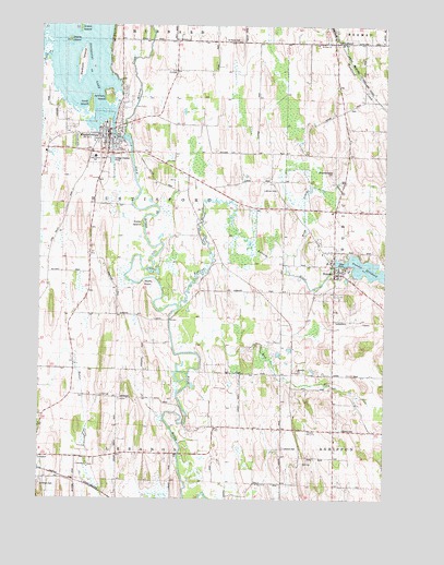
Hustisford, WI USGS Topographic Map
Click on map above to begin viewing in our Map Viewer.

This topographic map contains these locations and features:
Feature Name Type Latitude Longitude GNIS ID View Map
Anthony IslandIslandN43.3567°W88.6004°1560891View Map
Bethany Lutheran ChurchChurchN43.3489°W88.6009°1850636View Map
Bethany Lutheran SchoolSchoolN43.3490°W88.6016°2716446View Map
Coles IslandIslandN43.3228°W88.5882°1850656View Map
Crane IslandIslandN43.3739°W88.6118°1563506View Map
First Presbyterian ChurchChurchN43.3431°W88.5995°1850714View Map
Hepp CreekStreamN43.3147°W88.5359°1566313View Map
HustisfordPopulated PlaceN43.3461°W88.6007°1566830View Map
Hustisford 2WP888 DamDamN43.3467°W88.5984°1792144View Map
Hustisford Community LibraryBuildingN43.3467°W88.6111°2724002View Map
Hustisford Fire DepartmentBuildingN43.3434°W88.6003°2698022View Map
Hustisford Junior / Senior High SchoolSchoolN43.3378°W88.6051°1850740View Map
Hustisford Police DepartmentBuildingN43.3447°W88.6010°2759496View Map
John Hustis Elementary SchoolSchoolN43.3403°W88.6055°1850748View Map
Koch IslandIslandN43.3542°W88.6073°1567594View Map
Lake Country Victory High SchoolSchoolN43.3128°W88.5208°2716136View Map
Lebanon CemeteryCemeteryN43.2636°W88.5365°1850757View Map
Lehman CemeteryCemeteryN43.3319°W88.5395°1567952View Map
Mud RunStreamN43.2892°W88.5687°1570003View Map
NeoshoPopulated PlaceN43.3103°W88.5182°1570176View Map
Neosho / Rubicon / Ashippun Police DepartmentBuildingN43.3103°W88.5188°2759407View Map
Neosho Elementary SchoolSchoolN43.3105°W88.5133°1850790View Map
Neosho Fire DepartmentBuildingN43.3106°W88.5188°2697936View Map
Neosho MillpondReservoirN43.3100°W88.5045°1569495View Map
Neosho Post OfficePost OfficeN43.3103°W88.5167°2723987View Map
Radloff IslandIslandN43.3658°W88.6109°1572023View Map
Rubicon RiverStreamN43.3003°W88.5748°1572704View Map
Saint Bartholomew CemeteryCemeteryN43.3364°W88.5190°1572854View Map
Saint John ChurchChurchN43.3703°W88.5201°1850817View Map
Saint Michaels ChurchChurchN43.3711°W88.5762°1573371View Map
Saint Pauls CemeteryCemeteryN43.3711°W88.5532°1573035View Map
Saint Peters CemeteryCemeteryN43.2536°W88.6243°1850845View Map
Sinissippi LakeReservoirN43.3720°W88.6158°1574188View Map
Sinissippi Lake 509ReservoirN43.3467°W88.5984°1792145View Map
Stone IslandIslandN43.3708°W88.6157°1574919View Map
Town of HustisfordCivilN43.3269°W88.5957°1583426View Map
Village of HustisfordCivilN43.3458°W88.6049°1583425View Map
Village of NeoshoCivilN43.3101°W88.5193°1583792View Map
Wildcat CreekStreamN43.3458°W88.5954°1576737View Map
Wolfs PointCapeN43.3072°W88.5879°1850907View Map
WoodlandPopulated PlaceN43.3703°W88.5187°1576989View Map
Woodland Road School (historical)SchoolN43.3711°W88.5620°1576993View Map
Woodland Volunteer Fire DepartmentBuildingN43.3720°W88.5194°2698164View Map

Note: Coordinates in the location and feature list above are referenced to NAD83 datum.


Copyright (C) 2008-2024 Ryan Niemi / Sunset Dynamics ... All Rights Reserved