TopoQuest Logo
Do you find TopoQuest useful?
Help keep TopoQuest running and adding new maps/features by donating!
Bitcoin:  19c7KJd3qBynnjoSw5npx9KScwjBe4ifkT
Litecoin:  LXs6TkuXGGXo1vDsWCkWVdjQX94eUKd6ui
Home View Maps Find Maps Find Places Resources & Links


Ixonia, Wisconsin Topographic Map

USGS Map Title: Ixonia, WI
USGS Map MRC: 43088B5
DRG (GeoTIFF) Download: o43088b5.tif


Neighboring USGS Topographic Map Quads:


  Clyman, WI  
43088C6
 

  Hustisford, WI  
43088C5
 

  Hartford West, WI  
43088C4
 

  Watertown, WI  
43088B6
 

  Ixonia, WI  
43088B5
 

  Stonebank, WI  
43088B4
 

  Helenville, WI  
43088A6
 

  Oconomowoc West, WI  
43088A5
 

  Oconomowoc East, WI  
43088A4


Map MRC Location:

N44°
W89°
N44°
W88°
H8 H7 H6 H5 H4 H3 H2 H1
G8 G7 G6 G5 G4 G3 G2 G1
F8 F7 F6 F5 F4 F3 F2 F1
E8 E7 E6 E5 E4 E3 E2 E1
D8 D7 D6 D5 D4 D3 D2 D1
C8 C7 C6 C5 C4 C3 C2 C1
B8 B7 B6 B5 B4 B3 B2 B1
A8 A7 A6 A5 A4 A3 A2 A1
N43°
W89°
N43°
W88°

Ixonia, WI USGS 1:24K Topographic Map Preview:
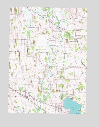
Ixonia, WI USGS Topographic Map
Click on map above to begin viewing in our Map Viewer.

This topographic map contains these locations and features:
Feature Name Type Latitude Longitude GNIS ID View Map
AshippunPopulated PlaceN43.2119°W88.5162°1560978View Map
Ashippun Census Designated PlaceCensusN43.2131°W88.5180°2586452View Map
Ashippun Elementary SchoolSchoolN43.2169°W88.5079°1850621View Map
Ashippun Post OfficePost OfficeN43.2104°W88.5159°2723990View Map
Ashippun RiverStreamN43.1706°W88.5540°1560981View Map
Ashippun Volunteer Fire Department Station 1BuildingN43.2124°W88.5172°2697662View Map
Baker CreekStreamN43.2464°W88.5715°1561100View Map
Bara FarmsLocaleN43.2003°W88.5342°2706381View Map
Beggs IslandIslandN43.1250°W88.5090°1561506View Map
Bethel CemeteryCemeteryN43.1443°W88.6137°2781314View Map
Bethel ChurchChurchN43.1442°W88.6137°1561634View Map
Buzzard PointCapeN43.1283°W88.5140°1850233View Map
C and L Hereford FarmLocaleN43.2017°W88.5500°2706382View Map
Crescentmead FarmLocaleN43.1975°W88.5167°2706383View Map
Cross Lutheran CemeteryCemeteryN43.1730°W88.5672°2781320View Map
Cross Lutheran ChurchChurchN43.1733°W88.5673°1840356View Map
Cross SchoolSchoolN43.1742°W88.5670°1563558View Map
Davy CreekStreamN43.2164°W88.5412°1563740View Map
Dawson CreekStreamN43.2342°W88.5454°1563744View Map
Fireman ParkParkN43.2158°W88.5265°1564957View Map
Glacier Rock FarmsLocaleN43.2378°W88.5628°2706419View Map
Glenview Memorial GardensCemeteryN43.1464°W88.5937°1565579View Map
IxoniaPopulated PlaceN43.1439°W88.5973°1567051View Map
Ixonia Census Designated PlaceCensusN43.1396°W88.5963°2393065View Map
Ixonia Elementary SchoolSchoolN43.1484°W88.5982°1840388View Map
Ixonia Fire DepartmentBuildingN43.1447°W88.5970°2697814View Map
Lac La BelleLakeN43.1299°W88.5185°1567708View Map
Lac La BellePopulated PlaceN43.1442°W88.5307°1567709View Map
Lac La Belle Police DepartmentBuildingN43.1396°W88.5409°2759556View Map
Lake Lac La BellePopulated PlaceN43.1308°W88.5445°1852245View Map
Monterey Methodist Episcopal CemeteryCemeteryN43.1783°W88.5319°2096700View Map
Monterey Village CemeteryCemeteryN43.1755°W88.5011°2096610View Map
Old AshippunPopulated PlaceN43.2247°W88.5198°1570768View Map
Old Ashippun Census Designated PlaceCensusN43.2230°W88.5182°2586537View Map
Pennsylvania Street SchoolSchoolN43.1581°W88.5195°1571180View Map
Redemptionist Fathers Catholic Seminary CemeteryCemeteryN43.1433°W88.5225°2096611View Map
Rosenow CreekStreamN43.1272°W88.5076°1577401View Map
Saint John Evangelical Lutheran ChurchChurchN43.2367°W88.5204°1851616View Map
Saint Johns SchoolSchoolN43.2375°W88.5198°1573125View Map
Saint Lukes ChurchChurchN43.1875°W88.5540°1573227View Map
Saint Marks CemeteryCemeteryN43.2219°W88.5556°1573238View Map
Saint Marks ChurchChurchN43.2258°W88.5604°1573240View Map
Sugar IslandPopulated PlaceN43.2258°W88.5798°1575026View Map
Tag Lane Dairy FarmLocaleN43.1681°W88.5731°2706380View Map
Town of IxoniaCivilN43.1525°W88.5975°1583440View Map
Town of LebanonCivilN43.2404°W88.5959°1583536View Map
Village of Lac La BelleCivilN43.1450°W88.5182°1583498View Map
Zion Lutheran ChurchChurchN43.2122°W88.5193°1851617View Map

Note: Coordinates in the location and feature list above are referenced to NAD83 datum.


Copyright (C) 2008-2024 Ryan Niemi / Sunset Dynamics ... All Rights Reserved