TopoQuest Logo
Do you find TopoQuest useful?
Help keep TopoQuest running and adding new maps/features by donating!
Bitcoin:  19c7KJd3qBynnjoSw5npx9KScwjBe4ifkT
Litecoin:  LXs6TkuXGGXo1vDsWCkWVdjQX94eUKd6ui
Home View Maps Find Maps Find Places Resources & Links


Hustontown, Pennsylvania Topographic Map

USGS Map Title: Hustontown, PA
USGS Map MRC: 40078A1
DRG (GeoTIFF) Download: o40078a1.tif


Neighboring USGS Topographic Map Quads:


  Saxton, PA  
40078B2
 

  Saltillo, PA  
40078B1
 

  Orbisonia, PA  
40077B8
 

  Wells Tannery, PA  
40078A2
 

  Hustontown, PA  
40078A1
 

  Burnt Cabins, PA  
40077A8
 

  Breezewood, PA  
39078H2
 

  Meadow Grounds, PA  
39078H1
 

  McConnellsburg, PA  
39077H8


Map MRC Location:

N41°
W79°
N41°
W78°
H8 H7 H6 H5 H4 H3 H2 H1
G8 G7 G6 G5 G4 G3 G2 G1
F8 F7 F6 F5 F4 F3 F2 F1
E8 E7 E6 E5 E4 E3 E2 E1
D8 D7 D6 D5 D4 D3 D2 D1
C8 C7 C6 C5 C4 C3 C2 C1
B8 B7 B6 B5 B4 B3 B2 B1
A8 A7 A6 A5 A4 A3 A2 A1
N40°
W79°
N40°
W78°

Hustontown, PA USGS 1:24K Topographic Map Preview:
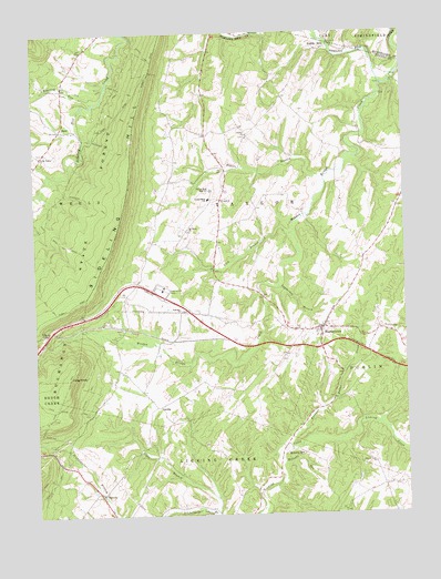
Hustontown, PA USGS Topographic Map
Click on map above to begin viewing in our Map Viewer.

This topographic map contains these locations and features:
Feature Name Type Latitude Longitude GNIS ID View Map
Anderson TrailTrailN40.0812°W78.1050°1168292View Map
Appalachian MountainsRangeN40.0004°W78.0000°1202929View Map
Cabin TrailTrailN40.0620°W78.1164°1170859View Map
Center ChurchChurchN40.0990°W78.0517°1171429View Map
Cherry Lane ChurchChurchN40.0134°W78.0106°1171648View Map
Dublin MillsPopulated PlaceN40.1206°W78.0264°1173564View Map
Elders BranchStreamN40.0870°W78.0258°1174078View Map
EnidPopulated PlaceN40.1006°W78.1156°1174250View Map
Enid School (historical)SchoolN40.0931°W78.1220°1197677View Map
Ensley TrailTrailN40.0101°W78.1217°1174281View Map
Fairview ChurchChurchN40.0526°W78.0747°1174513View Map
Flying R AirportAirportN40.0035°W78.0920°1193797View Map
Forbes Road Elementary SchoolSchoolN40.0820°W78.0656°1211463View Map
Forbes Road Junior-Senior High SchoolSchoolN40.0845°W78.0639°1210587View Map
Fortune Teller CreekStreamN40.0165°W78.0417°1175025View Map
GraceyPopulated PlaceN40.0818°W78.0608°1203705View Map
Gracey School (historical)SchoolN40.0818°W78.0622°1197682View Map
Green TrailTrailN40.0084°W78.1197°1176118View Map
HiramPopulated PlaceN40.0534°W78.0853°1197683View Map
HustontownPopulated PlaceN40.0490°W78.0269°1177652View Map
Hustontown Area Volunteer Fire Company - Station 57BuildingN40.0525°W78.0241°2644876View Map
Hustontown Post OfficePost OfficeN40.0481°W78.0303°2772756View Map
Keith TrailTrailN40.1037°W78.0950°1178311View Map
King KnobSummitN40.0356°W78.1136°1178478View Map
Kings TrailTrailN40.0315°W78.1164°1178499View Map
LaidigPopulated PlaceN40.0284°W78.0831°1203973View Map
Lamberson BranchStreamN40.0598°W78.0417°1178820View Map
Lick BranchStreamN40.0626°W78.0970°1179275View Map
Mellotts MillPopulated PlaceN40.0173°W78.0383°1204149View Map
Mellotts RunStreamN40.0137°W78.0414°1180887View Map
Mitchell TrailTrailN40.0237°W78.1217°1181378View Map
Mount Tabor ChurchChurchN40.0743°W78.0719°1181857View Map
Roaring RunStreamN40.1073°W78.1042°1185180View Map
Rocky Face TrailTrailN40.1104°W78.0931°1185347View Map
SaluviaPopulated PlaceN40.0054°W78.1033°1186889View Map
School Number 3SchoolN40.1109°W78.1161°1197678View Map
Sciotha TrailTrailN40.0656°W78.1217°1187148View Map
Sideling Hill PlazaLocaleN40.0590°W78.0811°1187652View Map
Sipes BranchStreamN40.0006°W78.0642°1187726View Map
Township of TaylorCivilN40.0770°W78.0535°1216480View Map
Vallance SchoolSchoolN40.0020°W78.0203°1197684View Map
Waterfall School (historical)SchoolN40.1140°W78.0667°1197679View Map
Wells Valley ChurchChurchN40.0937°W78.1220°1190815View Map
Winegardner School (historical)SchoolN40.1056°W78.0364°1197680View Map
Wintergreen SchoolSchoolN40.0729°W78.0175°1197681View Map
Winters TrailTrailN40.0323°W78.1072°1191614View Map
Woodcock TrailTrailN40.0956°W78.0983°1191730View Map
Wooden Bridge CreekStreamN40.1112°W78.0056°1191733View Map

Note: Coordinates in the location and feature list above are referenced to NAD83 datum.


Copyright (C) 2008-2024 Ryan Niemi / Sunset Dynamics ... All Rights Reserved