TopoQuest Logo
Do you find TopoQuest useful?
Help keep TopoQuest running and adding new maps/features by donating!
Bitcoin:  19c7KJd3qBynnjoSw5npx9KScwjBe4ifkT
Litecoin:  LXs6TkuXGGXo1vDsWCkWVdjQX94eUKd6ui
Home View Maps Find Maps Find Places Resources & Links


Wells Tannery, Pennsylvania Topographic Map

USGS Map Title: Wells Tannery, PA
USGS Map MRC: 40078A2
DRG (GeoTIFF) Download: o40078a2.tif


Neighboring USGS Topographic Map Quads:


  Hopewell, PA  
40078B3
 

  Saxton, PA  
40078B2
 

  Saltillo, PA  
40078B1
 

  Everett East, PA  
40078A3
 

  Wells Tannery, PA  
40078A2
 

  Hustontown, PA  
40078A1
 

  Mench, PA  
39078H3
 

  Breezewood, PA  
39078H2
 

  Meadow Grounds, PA  
39078H1


Map MRC Location:

N41°
W79°
N41°
W78°
H8 H7 H6 H5 H4 H3 H2 H1
G8 G7 G6 G5 G4 G3 G2 G1
F8 F7 F6 F5 F4 F3 F2 F1
E8 E7 E6 E5 E4 E3 E2 E1
D8 D7 D6 D5 D4 D3 D2 D1
C8 C7 C6 C5 C4 C3 C2 C1
B8 B7 B6 B5 B4 B3 B2 B1
A8 A7 A6 A5 A4 A3 A2 A1
N40°
W79°
N40°
W78°

Wells Tannery, PA USGS 1:24K Topographic Map Preview:
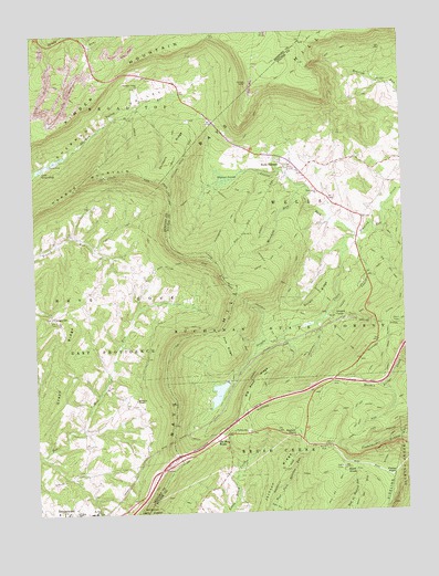
Wells Tannery, PA USGS Topographic Map
Click on map above to begin viewing in our Map Viewer.

This topographic map contains these locations and features:
Feature Name Type Latitude Longitude GNIS ID View Map
Bald KnobSummitN40.0106°W78.1456°1168643View Map
Beaverdam PondLakeN40.0484°W78.1581°1201682View Map
Big Fill TrailTrailN40.0423°W78.1650°1169504View Map
Big Wood RidgeRidgeN40.0323°W78.1767°1169607View Map
Bills Place (historical)Populated PlaceN40.0159°W78.2014°1197692View Map
Borough of Valley-HiCivilN40.0299°W78.1917°2086651View Map
Breezewood Volunteer Fire Department - Station 40BuildingN40.0006°W78.2434°2644977View Map
Budds PlacePopulated PlaceN40.0173°W78.1506°1197693View Map
Childers RidgeRidgeN40.0954°W78.2014°1171777View Map
Childers Ridge TrailTrailN40.1001°W78.2078°1206712View Map
Cornelius TrailTrailN40.0915°W78.2025°1172464View Map
Duvall RidgeRidgeN40.0531°W78.1558°1173668View Map
Duvall TrailTrailN40.0556°W78.1517°1173669View Map
Fisher PointSummitN40.0090°W78.1297°1174821View Map
Garlick MineMineN40.1115°W78.1761°1175453View Map
GlendaleLocaleN40.1234°W78.2220°1207661View Map
GracevillePopulated PlaceN40.0515°W78.2436°1175912View Map
Graceville Lutheran Church CemeteryCemeteryN40.0512°W78.2442°2776083View Map
Grape RidgeRidgeN40.0426°W78.2395°1175975View Map
Harbor MountainSummitN40.0879°W78.2286°1176499View Map
Hinish CemeteryCemeteryN40.0640°W78.2114°2776087View Map
Horton Jeep TrailTrailN40.0673°W78.1686°1177476View Map
Huckleberry TrailTrailN40.0756°W78.1847°1177548View Map
Jackson RidgeRidgeN40.0012°W78.1731°1177926View Map
JerkwaterPopulated PlaceN40.1223°W78.2425°1197686View Map
Jerry TrailTrailN40.0248°W78.1420°1178056View Map
Kimber MountainSummitN40.1204°W78.2028°1178459View Map
Laidig Spring TrailTrailN40.0268°W78.1408°1178764View Map
Lake GroundhogLakeN40.0900°W78.2473°1176269View Map
Laurel ForkStreamN40.0715°W78.1408°1178932View Map
Meredith RunStreamN40.0845°W78.1567°1180945View Map
Meredith TrailTrailN40.0759°W78.1700°1180947View Map
Moseby TrailTrailN40.0826°W78.1942°1181600View Map
Mount Zion ChurchChurchN40.0004°W78.2306°1181912View Map
Mount Zion Lutheran Church CemeteryCemeteryN40.0000°W78.2302°2776124View Map
Mountain ChapelChurchN40.0293°W78.2158°1181946View Map
Mountain Chapel Church CemeteryCemeteryN40.0293°W78.2150°2776125View Map
Mountain School (historical)SchoolN40.0717°W78.2422°1197689View Map
Old Mountain HousePopulated PlaceN40.0190°W78.1889°1204325View Map
Oregon CampLocaleN40.0504°W78.1489°1183035View Map
Oregon CreekStreamN40.0715°W78.1406°1183037View Map
Pa-32 DamDamN40.0351°W78.1831°1194506View Map
Pennsylvania Conservation and Natural Resources District 2 Buchanan Sideling Hill TrailBuildingN40.0172°W78.1505°2645599View Map
Pine Grove ChurchChurchN40.0829°W78.1531°1183807View Map
Pine Grove SchoolSchoolN40.0837°W78.1539°1197691View Map
Pine RidgeRidgeN40.0437°W78.1847°1183865View Map
Prop TrailTrailN40.0595°W78.1258°1193162View Map
Rays Hill TunnelTunnelN40.0187°W78.2036°1184729View Map
Red Bank TrailTrailN40.0387°W78.1775°1184748View Map
Sandy RunPopulated PlaceN40.1217°W78.2303°1197685View Map
Sandy Run School (historical)SchoolN40.1240°W78.2336°1205941View Map
Sherman Valley ChurchChurchN40.1112°W78.2133°1187492View Map
Shermans Valley Church GraveyardCemeteryN40.1109°W78.2141°2776160View Map
Shortys PlacePopulated PlaceN40.0198°W78.1617°1187605View Map
Sideling Hill TunnelTunnelN40.0484°W78.1292°1193362View Map
Snowfield TrailTrailN40.0523°W78.1653°1187949View Map
Sproat TrailTrailN40.0343°W78.1750°1188316View Map
Tower TrailTrailN40.0093°W78.1564°1189684View Map
Township of WellsCivilN40.0906°W78.1399°1216483View Map
Union School (historical)SchoolN40.0595°W78.2167°1197688View Map
Valley-HiPopulated PlaceN40.0293°W78.1914°1197687View Map
Valley-Hi Eagle LakeReservoirN40.0351°W78.1831°1194507View Map
Warsing School (historical)SchoolN40.1129°W78.2058°1197690View Map
Waterflat TrailTrailN40.0726°W78.1783°1190673View Map
Wells TanneryPopulated PlaceN40.0912°W78.1664°1190814View Map
Wells Tannery Post OfficePost OfficeN40.0892°W78.1630°2779681View Map
Wishart SwampSwampN40.0870°W78.1849°1191622View Map

Note: Coordinates in the location and feature list above are referenced to NAD83 datum.


Copyright (C) 2008-2024 Ryan Niemi / Sunset Dynamics ... All Rights Reserved