TopoQuest Logo
Do you find TopoQuest useful?
Help keep TopoQuest running and adding new maps/features by donating!
Bitcoin:  19c7KJd3qBynnjoSw5npx9KScwjBe4ifkT
Litecoin:  LXs6TkuXGGXo1vDsWCkWVdjQX94eUKd6ui
Home View Maps Find Maps Find Places Resources & Links


Breezewood, Pennsylvania Topographic Map

USGS Map Title: Breezewood, PA
USGS Map MRC: 39078H2
DRG (GeoTIFF) Download: o39078h2.tif


Neighboring USGS Topographic Map Quads:


  Everett East, PA  
40078A3
 

  Wells Tannery, PA  
40078A2
 

  Hustontown, PA  
40078A1
 

  Mench, PA  
39078H3
 

  Breezewood, PA  
39078H2
 

  Meadow Grounds, PA  
39078H1
 

  Amaranth, PA  
39078G3
 

  Needmore, PA  
39078G2
 

  Big Cove Tannery, PA  
39078G1


Map MRC Location:

N40°
W79°
N40°
W78°
H8 H7 H6 H5 H4 H3 H2 H1
G8 G7 G6 G5 G4 G3 G2 G1
F8 F7 F6 F5 F4 F3 F2 F1
E8 E7 E6 E5 E4 E3 E2 E1
D8 D7 D6 D5 D4 D3 D2 D1
C8 C7 C6 C5 C4 C3 C2 C1
B8 B7 B6 B5 B4 B3 B2 B1
A8 A7 A6 A5 A4 A3 A2 A1
N39°
W79°
N39°
W78°

Breezewood, PA USGS 1:24K Topographic Map Preview:
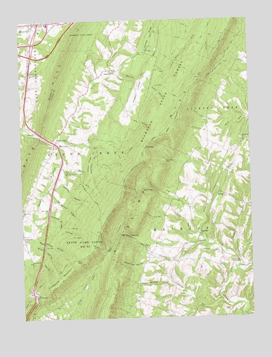
Breezewood, PA USGS Topographic Map
Click on map above to begin viewing in our Map Viewer.

This topographic map contains these locations and features:
Feature Name Type Latitude Longitude GNIS ID View Map
AkersvillePopulated PlaceN39.9784°W78.1978°1202954View Map
Bald Hill TrailTrailN39.9940°W78.1575°1168642View Map
Barton RunStreamN39.9418°W78.2275°1168783View Map
Barton TrailTrailN39.9412°W78.1958°1168785View Map
Bear PondLakeN39.8991°W78.2203°1168900View Map
Bear Wallow HollowValleyN39.9161°W78.2430°1168965View Map
Betsey GapGapN39.9287°W78.1778°1169438View Map
Bold Hill TrailTrailN39.9940°W78.1575°1192177View Map
BreezewoodPopulated PlaceN39.9993°W78.2386°1170190View Map
Breezewood Elementary SchoolSchoolN39.9973°W78.2442°1211460View Map
Breezewood Post OfficePost OfficeN39.9981°W78.2431°2777376View Map
Buffalo School (historical)SchoolN39.9415°W78.2283°1196912View Map
Chestnut Bridge HollowValleyN39.9177°W78.2428°1192254View Map
Crane RunStreamN39.9095°W78.1528°1172641View Map
Crystal SpringPopulated PlaceN39.9498°W78.2286°1172804View Map
Crystal SpringSpringN39.9365°W78.2250°1196913View Map
Crystal Spring CampLocaleN39.9365°W78.2250°1172806View Map
Crystal Springs Post OfficePost OfficeN39.9470°W78.2319°2772657View Map
Cummings RunStreamN39.8818°W78.1403°1172832View Map
Daves GapPopulated PlaceN39.9104°W78.1914°1203391View Map
Deer Hill TrailTrailN39.9956°W78.1542°1192338View Map
Ditch Run HollowValleyN39.9524°W78.1455°1173305View Map
East Fork Roaring RunStreamN39.9812°W78.1786°1192405View Map
Ebenezer ChurchChurchN39.9259°W78.1392°1173946View Map
EmmavillePopulated PlaceN39.9104°W78.2495°1174243View Map
Emmaville MountainSummitN39.8954°W78.2236°1174244View Map
Foster CreekStreamN39.8870°W78.1417°1175038View Map
GapsvillePopulated PlaceN39.9534°W78.2417°1175425View Map
Green RidgeRidgeN39.9395°W78.2120°1176104View Map
Haumans StoreLocaleN39.9295°W78.1425°1196911View Map
Hen Barton HollowValleyN39.9288°W78.2355°1176821View Map
Jackson TrailTrailN39.9918°W78.1589°1177936View Map
Laurel RunStreamN39.9465°W78.2083°1178971View Map
Little Brush CreekStreamN39.9484°W78.2314°1179486View Map
Maple HollowValleyN39.9764°W78.1816°1180347View Map
Marshall HollowValleyN39.9310°W78.2275°1180468View Map
Mc Kendree ChurchChurchN39.9201°W78.2492°1180596View Map
Mine GapGapN39.9637°W78.1614°1181305View Map
Packers PathTrailN39.9373°W78.1989°1193077View Map
Pittman TrailTrailN39.9798°W78.1408°1183978View Map
Pleasant ValleyValleyN39.9747°W78.1848°1184065View Map
Poplar Springs HollowValleyN39.8883°W78.1682°1184263View Map
Roaring RunStreamN39.9823°W78.2058°1185169View Map
Roaring Run TrailTrailN39.9809°W78.1614°1185188View Map
Rock Oak TrailTrailN39.9979°W78.1450°1206713View Map
Rockhouse HollowValleyN39.8979°W78.1846°1185310View Map
Sawmill RunStreamN39.9056°W78.1483°1187027View Map
Shaw Cabin HollowValleyN39.9462°W78.2083°1187391View Map
Sideling Hill ChurchChurchN39.9070°W78.1536°1187649View Map
Sideling Hill ChurchChurchN39.9498°W78.1283°1187650View Map
Sipes MillPopulated PlaceN39.9106°W78.1525°1205082View Map
Slippery Elm HollowValleyN39.9178°W78.1729°1187821View Map
Smith HollowValleyN39.9085°W78.2476°1187874View Map
Swope GapGapN39.9468°W78.1811°1189197View Map
The BasinSlopeN39.9081°W78.2182°1189389View Map
The BowlLocaleN39.9120°W78.1956°1189393View Map
The Little PointCliffN39.9409°W78.1703°1189419View Map
Township of BelfastCivilN39.8810°W78.1405°1216475View Map
Township of Brush CreekCivilN39.9312°W78.2138°1729680View Map
West Fork Roaring RunStreamN39.9815°W78.1786°1191028View Map

Note: Coordinates in the location and feature list above are referenced to NAD83 datum.


Copyright (C) 2008-2024 Ryan Niemi / Sunset Dynamics ... All Rights Reserved